
Jasper Creek
By Armen Suny · Last verified Jun 2026
Photo Credits (1)
About Jasper Creek
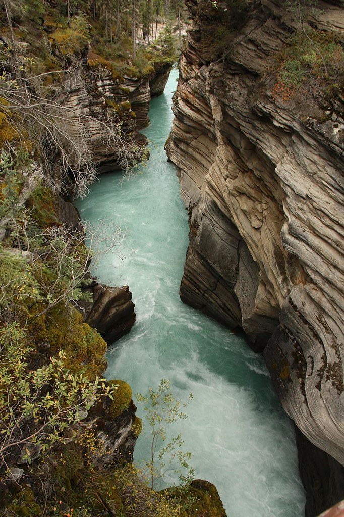
Jasper Creek is a small forested creek and cascade on southern Vancouver Island, located near the Saanich Peninsula at coordinates 48.7699, -123.5376. The feature appears to be a modest waterfall or cascade rather than a large vertical drop. Flow and accessibility are seasonally variable; highest flows are typically in spring and after heavy rain. Some details about formal trails, official park boundaries, and exact drop height are not well documented and appear to be limited in published resources.
Why This Waterfall Exists
Jasper Creek flows over hard volcanic rock laid down about 252-419 million years ago. These resistant rocks form a durable ledge that water cannot easily wear away, creating the falls where softer material downstream has already eroded.
Trail & Hike Details
Trail Description
Published information about an established maintained trail to Jasper Creek is limited. Visiting may involve following an unmarked or lightly used footpath through mixed second-growth forest and Pacific Northwest understory, with short uneven sections and possible brush/scramble to reach viewpoints. Expect slippery ground and roots; there may not be formal viewpoints, railings, or boardwalks.
What to Expect
A small cascade or series of drops rather than a large waterfall. Forested setting typical of southern Vancouver Island (Douglas-fir, arbutus in drier spots, salal, ferns). Water flow is seasonal, stronger in spring and after heavy rain, lower in late summer. Limited amenities, signage, or facilities. Views may be close and intimate rather than panoramic. Trails may be muddy, rooty, and narrow.
Accessibility
Likely not wheelchair accessible. Trails or approaches are probably uneven, narrow, and may include short scrambles; expect muddy or root-covered surfaces.
Frequently Asked Questions
🐶 Are Dogs Allowed at Jasper Creek?
❌ Dogs are not allowed
Are There Any Fees or Permits Required?
🆖 No fees required
🏊 Is There Swimming at Jasper Creek?
❌ Swimming is not allowed
When to Visit
Spring (late winter–spring) for highest water flow and late winter runoff. Fall also provides wetter conditions and good flow after autumn rains. Summer may have reduced flow but better trail conditions. Winter can be wet and muddy and may make approach more difficult.
Seasonal Access
The best time to visit is Spring, Summer, Fall, and Winter. Check with the managing park or local authority for current conditions.
Safety Information
• Slippery rocks and wet roots can cause falls, use caution and appropriate footwear. • Water levels can rise quickly after rain; avoid approaching banks during high flow. • Trails may cross or approach private property, confirm legal access to avoid trespass. • Limited or no cell service in places; tell someone your route and expected return time. • Watch for wildlife and give animals space. • There may be no lifeguards or rescue services nearby, act conservatively around water.
Current Water Conditions
0.3 m³/s
Current discharge — how much water is flowing
Much lower than usual for this time of year
Based on 73 years of record
0.41 m
Water depth at gauge
7-Day Discharge Trend
What does this mean for your visit?
Flow is well below normal for this time of year, so the waterfall may be a trickle.
About This Gauge
This gauge is on a nearby waterway and may not reflect exact conditions at the falls.
7-Day Flow Outlook
Based on the WSC gauge KOKSILAH RIVER AT COWICHAN STATION (11 km away).
Today
Barely Flowing
0.3 m³/s
5/10Tomorrow
Barely Flowing
0.2 m³/s
4/10Tue
Barely Flowing
0.2 m³/s
4/10Wed
Barely Flowing
0.2 m³/s
4/10Thu
Barely Flowing
0.3 m³/s
3/10Fri
Barely Flowing
0.2 m³/s
4/10Sat
Barely Flowing
0.2 m³/s
4/10Best window: Today — barely flowing flow, sunny (trip score 5/10).
Best time of year: this gauge typically runs highest from late November to late December, peaking in December.
How we calculate this
This is a transparent outlook, not a precise forecast. We take the waterfall's current flow strength (how it ranks against its historical normal for today, from the nearest WSC stream gauge), carry that ranking forward along the gauge's seasonal curve, and nudge it for forecast rain. Confidence is highest for the next day or two and falls further out. Always check official conditions and your own judgment before visiting — high flows can be dangerous.
Know when to go.
Get a free email alert when waterfalls near Victoria hit peak flow. We only send when conditions are worth the trip — no weekly newsletters, no spam.
Weather Forecast
Location & Access
Getting There
Located at 48.7699, -123.5376 on southern Vancouver Island, roughly 24 miles (38 km) north of downtown Victoria and a short drive from Sidney. Access is typically from local roads on the Saanich Peninsula; exact trailheads may be unmarked and access can require navigation on minor roads or informal footpaths. Confirm access before visiting and use the coordinates to orient yourself.
Get Directions on Google MapsParking
Parking may be informal or roadside and could be limited. There does not appear to be a large formal parking lot specifically for this site; park legally and avoid blocking driveways or narrow shoulders.
Elevation
320 metres above sea level
Coordinates
48.769911° N, -123.537600° W
Visitor Tips & Gear
• Use the provided coordinates (48.7699, -123.5376) and a reliable map or GPS to locate the site. • Wear sturdy, waterproof footwear, rocks and trails can be slippery. • Expect limited or no facilities (no toilets, no formal viewpoints, limited parking). • Be respectful of private property, confirm that access crosses public land before entering. • Leave no trace: pack out all trash. • Cell service may be spotty in parts of the Saanich Peninsula; download maps offline if possible.
Where to Stay
Browse vacation cabins and private rentals nearby
Unique outdoor stays — tents, yurts, and treehouses
Rent a campervan or RV for your waterfall road trip
Some links are affiliate links. We may earn a commission at no extra cost to you.
Nearby Campground
Mowhinna Creek Campground
8.4 km away
Additional Information
Nearby Attractions
Greater Victoria (butchart Gardens, downtown Victoria), Sidney-by-the-Sea, local waterfront parks on the Saanich Peninsula, Gulf Island ferry terminals (Swartz Bay), nearby regional trails and local parks. Roche Harbor and Point Roberts are across the water and reached by ferry/boat.
Wildlife
Typical southern Vancouver Island wildlife may be present: songbirds, waterfowl, small mammals (squirrels, raccoons), deer. Black bears and cougars occur on Vancouver Island but are less common near heavily populated parts of the Saanich Peninsula, remain aware and store food responsibly. Also watch for ticks and stinging insects during warmer months.
Cities near Jasper Creek
Nearby Waterfalls
Other waterfalls named Jasper Creek
3 other waterfalls share this name across Canada.
Writing about Jasper Creek? Embed this waterfall on your site for free.