Indian Oils Waterfalls
Alberta • 2 m
By Armen Suny · Last verified Jun 2026
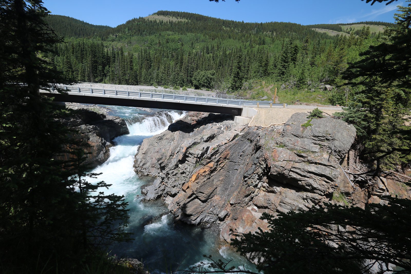
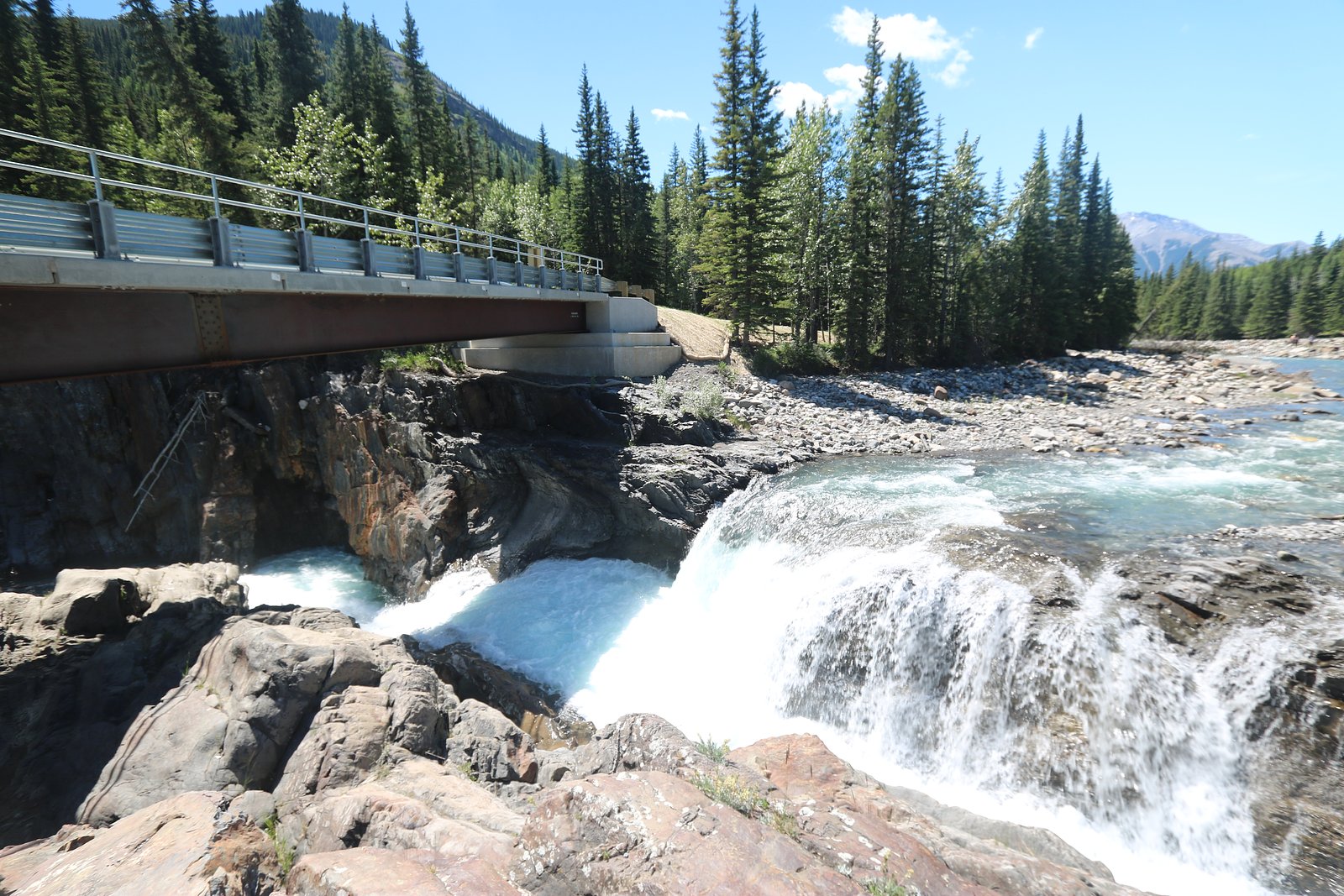
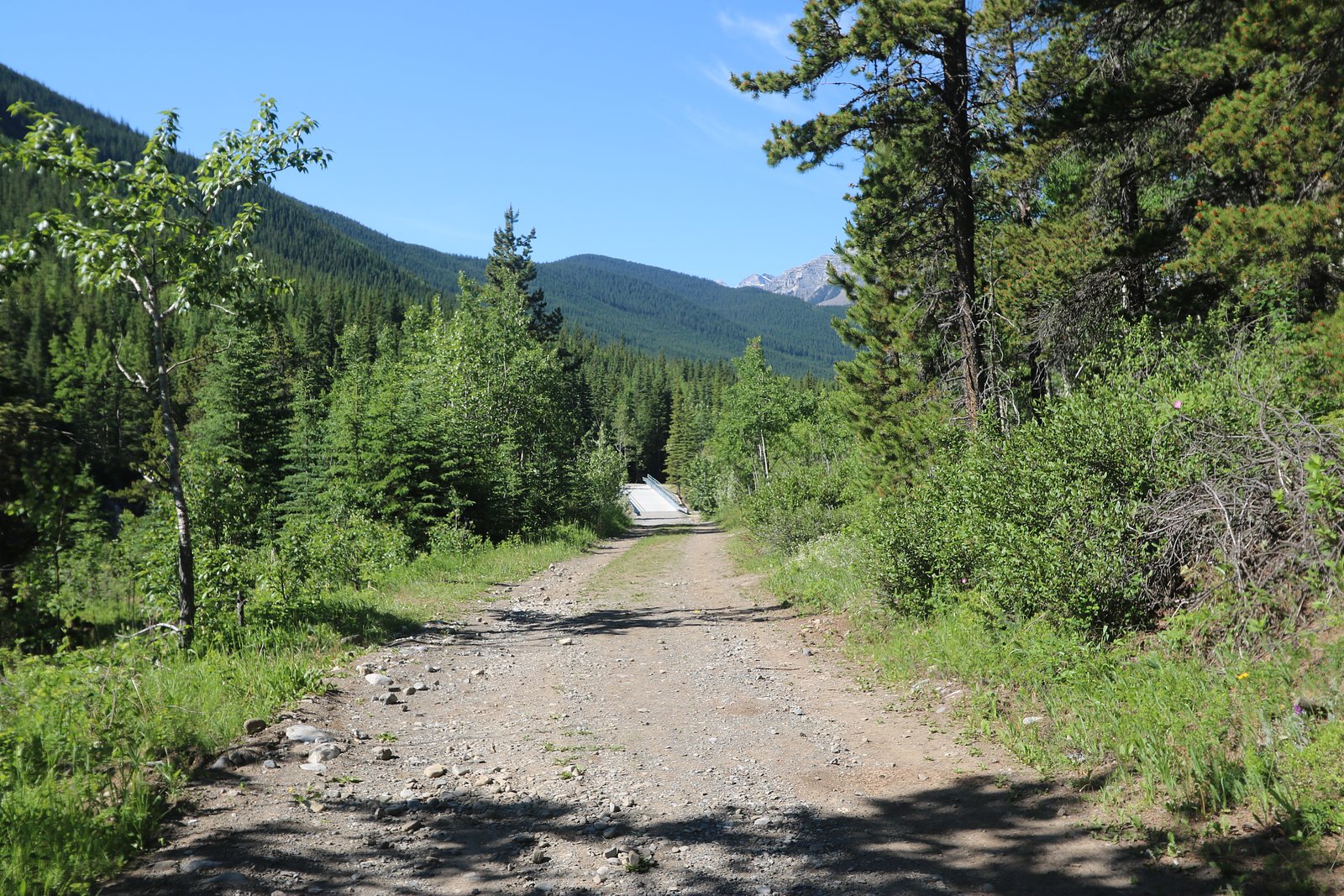
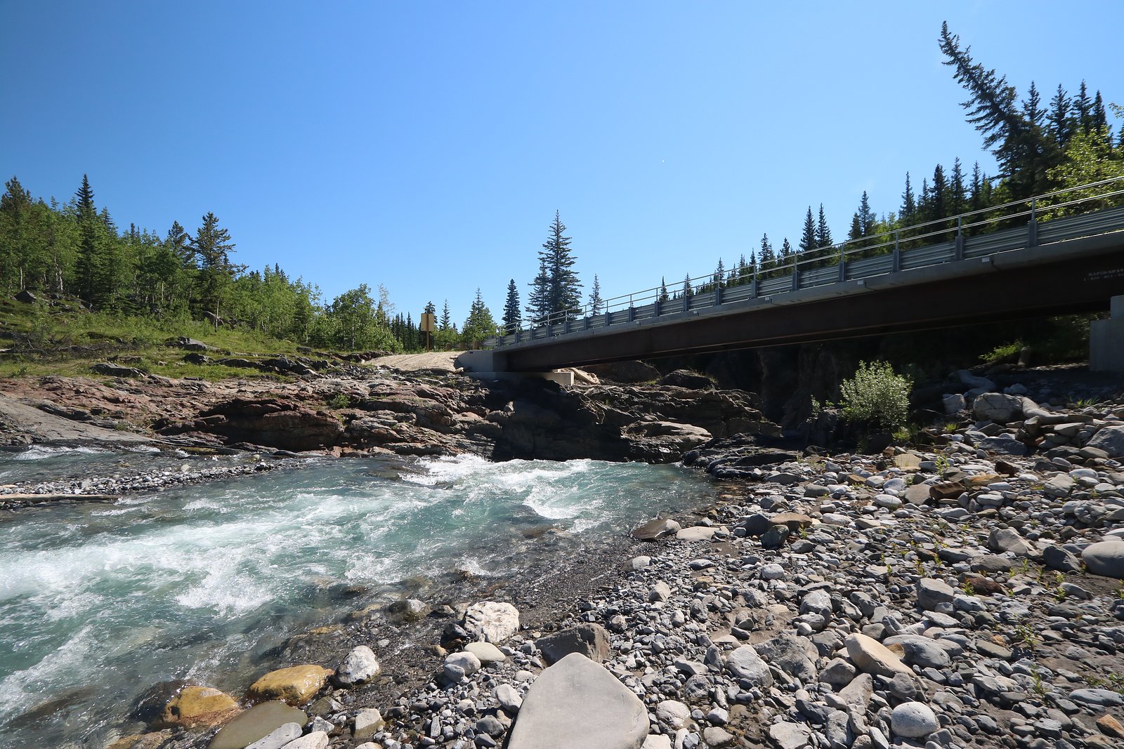
Photo Credits (5)
Difficulty
Moderate
Trail Length
8.5 km
Trail Type
Out And Back
Elevation Gain
297 m
About Indian Oils Waterfalls
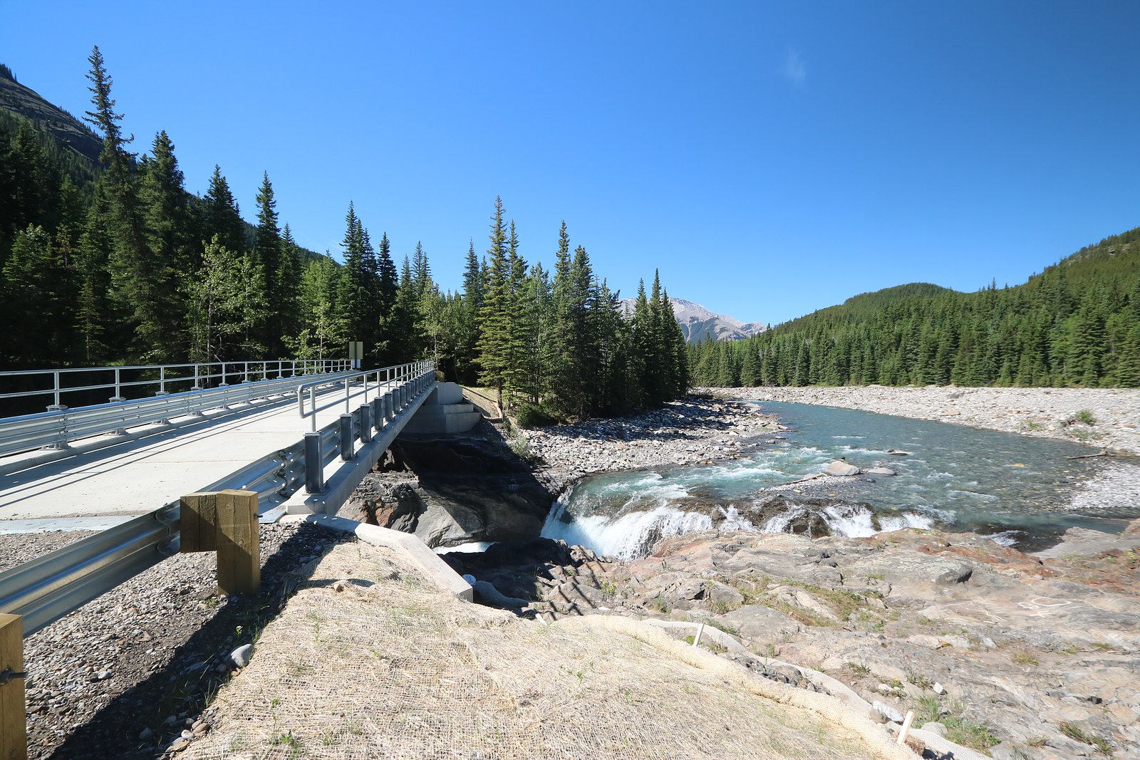
Indian Oils Waterfalls is a lesser-known cascade in the Alberta foothills at coordinates 50.6195, -114.6977, roughly 48.7 miles from Calgary and about 63.5 miles from Banff. It appears to sit on a small tributary in the Bow Valley / Kananaskis region. Visitor information is limited; access often uses secondary or forest service roads and a short hike. Flow and access are seasonal, highest flows are typically during spring snowmelt and after heavy rains. Many specific details (official trailhead, maintained trail status, and exact height) are not well-documented online, so visitors should confirm current conditions locally before heading out.
The Setting
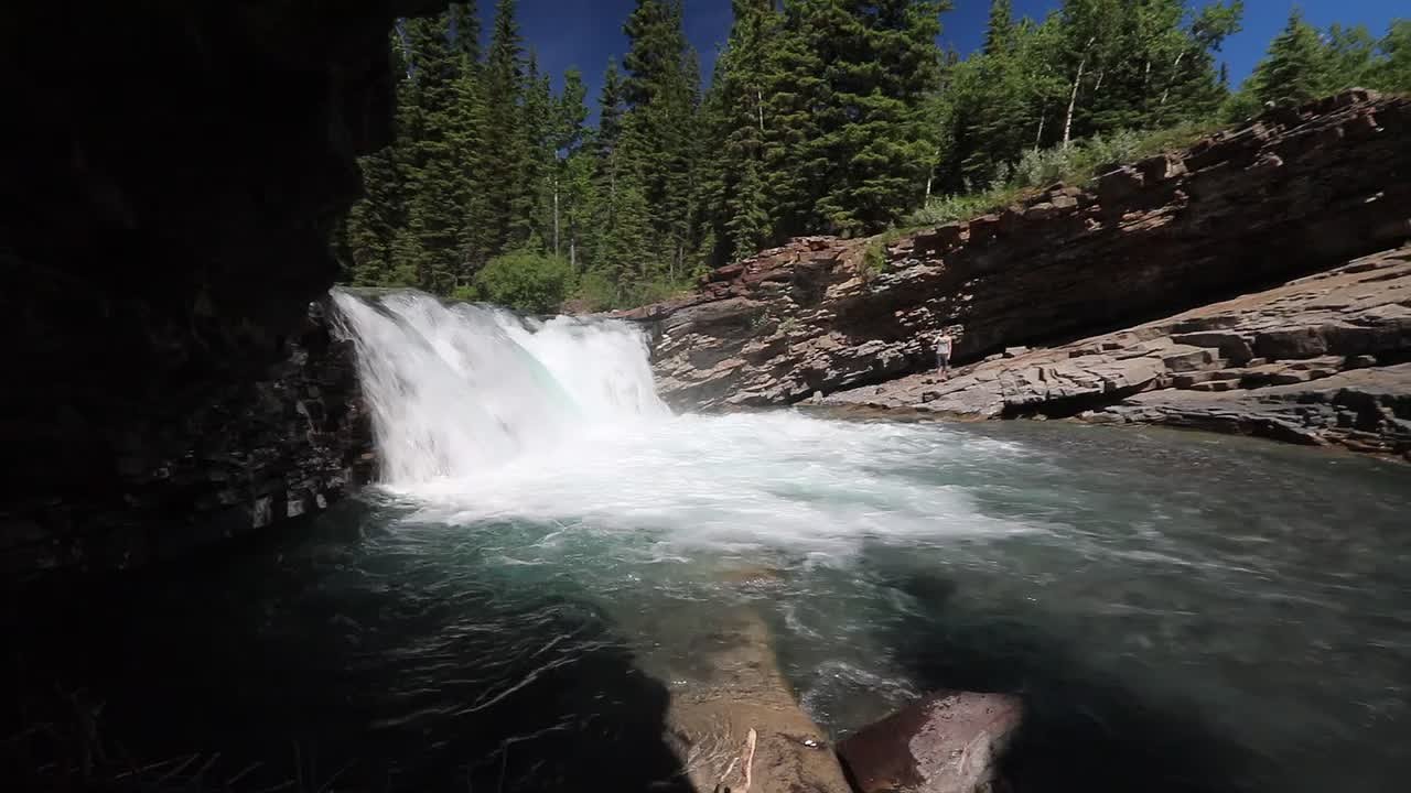
Indian Oils Waterfalls sits at 1,545 metres within Sheep River Provincial Park, in the high mountains of Alberta. The falls drop 2 metres.
Why This Waterfall Exists
Indian Oils Waterfalls flows over Blairmore Group, a layered sedimentary rock layer deposited about 101-145 million years ago. These soft rocks erode readily, allowing the stream to carve a 6-foot drop into the landscape.
Nearby Falls Worth Visiting
Sheep River Falls (10 m) lies 0.6 kilometres to the southwest.
Trail & Hike Details
The Approach
The moderate 8.5-km out-and-back trail gains 297 metres of elevation on the way to the falls.
Trail Description
There is limited published information about an established, maintained trail to Indian Oils Waterfalls. Expect an unmarked or minimally signed approach from a forest service/secondary road with short off-trail walking, possible route-finding, stream crossings, and sections of uneven or steep terrain. Surfaces will likely be muddy and rocky near the falls; the final approach could involve scrambling over wet, slippery rocks. Because authoritative trail data is sparse, treat the route as undeveloped and prepare for variable conditions. If you are not comfortable with navigation or scrambling, consider visiting with someone who is familiar with the area or hiring a local guide.
What to Expect
The falls drop a gentle 2 metres over layered sedimentary rock.
Accessibility
The trail is not wheelchair accessible. Uneven terrain and elevation changes require steady footing.
Frequently Asked Questions
🐶 Are Dogs Allowed at Indian Oils Waterfalls?
❌ Dogs are not allowed
Are There Any Fees or Permits Required?
🆖 No fees required
🏊 Is There Swimming at Indian Oils Waterfalls?
❌ Swimming is not allowed
When to Visit
Late spring (May–June) for strongest water flow from snowmelt and lower risk of muddy roads once thawed. Early summer is generally pleasant for hiking. Fall offers cooler temperatures and fall colors but lower flows. Winter can offer frozen features for viewing/photography but brings significant access, ice, and safety hazards.
Seasonal Access
The best time to visit is Spring, Summer, Fall, and Winter. Check with the managing park or local authority for current conditions.
Safety Information
Hazards include slippery and unstable rocks near the waterfall, steep drop-offs, fast cold water, variable weather, seasonal road closures, and wildlife encounters. Roads to the site may be impassable after heavy rain or during spring melt and winter. Always tell someone your plans and estimated return time, check local conditions before leaving, carry appropriate safety equipment (map, layers, emergency kit), and carry bear spray in bear country. Do not approach the edge of the falls or attempt cliff jumping. If conditions are icy, use traction aids and avoid the edge entirely.
Current Water Conditions
Based on a Water Survey of Canada gauge 25.1 km away
4.6 m³/s
Current discharge — how much water is flowing
Much higher than usual for this time of year
Based on 46 years of record
2.29 m
Water depth at gauge
7-Day Discharge Trend
What does this mean for your visit?
The water is flowing much higher than usual, expect an impressive display.
About This Gauge
This gauge is on a regional waterway. Conditions at the falls may differ, especially after local rain.
7-Day Flow Outlook
Based on the WSC gauge TRAP CREEK NEAR LONGVIEW (25 km away).
Today
Roaring
4.6 m³/s
9/10Tomorrow
Roaring
4.9 m³/s
6/10Tue
Roaring
4.8 m³/s
6/10Wed
Roaring
4.7 m³/s
6/10Thu
Roaring
4.1 m³/s
8/10Fri
Roaring
3.8 m³/s
8/10Sat
Roaring
3.8 m³/s
9/10Best window: Today — roaring flow, sunny (trip score 9/10).
Best time of year: this gauge typically runs highest from mid May to early July, peaking in June.
How we calculate this
This is a transparent outlook, not a precise forecast. We take the waterfall's current flow strength (how it ranks against its historical normal for today, from the nearest WSC stream gauge), carry that ranking forward along the gauge's seasonal curve, and nudge it for forecast rain. Confidence is highest for the next day or two and falls further out. Always check official conditions and your own judgment before visiting — high flows can be dangerous.
Know when to go.
Get a free email alert when waterfalls near Calgary hit peak flow. We only send when conditions are worth the trip — no weekly newsletters, no spam.
Weather Forecast
Location & Access
Getting There
From Calgary: head west on Trans-Canada Hwy (Hwy 1) toward Canmore/Exshaw then follow local secondary highways and forest service roads toward the provided coordinates. From Banff: head east on Hwy 1 and use local roads/forest service spurs. Exact access routes vary by season and by which forestry/bridle road is open; some sections may require high-clearance or 4x4 vehicles. Expect unpaved roads, possible seasonal closures, and limited signage. Confirm directions and road conditions with local visitor centres, the municipal office for Kananaskis/Canmore area, or Parks/Forestry web pages.
Get Directions on Google MapsParking
Parking is likely limited to a small pullout/shoulder or an informal/unmarked lot near the access road. There may not be an official maintained parking area; expect limited spaces and possibly tight roadside parking. Park legally and avoid blocking gates or private driveways. Seasonal road conditions can reduce available parking.
Elevation
1,545 metres above sea level
Coordinates
50.619475° N, -114.697697° W
Land Management
Managed by Parks Division, Alberta Forestry and Parks
Visitor Tips & Gear
1) Confirm road and trail conditions locally before you go, forestry roads and secondary routes may be gated or seasonally closed. 2) Use a high-clearance vehicle if traveling forest service roads; 4x4 may be advisable in wet or snowy conditions. 3) Wear sturdy waterproof boots and bring traction devices for winter. 4) Stay back from edges and wet rock; falls and unstable banks are a hazard. 5) Pack out all trash; no services are likely at the site. 6) Carry a map, GPS or offline map tile for navigation; cell coverage may be limited. 7) Be bear-aware: carry bear spray and know how to use it. 8) If unsure about route-finding, consider a local guide or stick to more documented nearby waterfalls and trails.
As an Amazon Associate, we earn from qualifying purchases.
With 8.5 km and 297 m of elevation gain, sturdy boots and trekking poles will help on this moderate trail. Icy conditions are common in winter — traction cleats are a smart addition.

Columbia Watertight II Rain Jacket
Packs into its own pocket, seam-sealed, and keeps you dry from spray and surprise rain.

Polarized Sunglasses (Knockaround)
Cuts glare off the water so you actually see the falls — and your photos turn out better too.

Earth Pak Waterproof Dry Bag
Keeps your phone and gear dry when waterfall mist soaks everything else.

Waterproof Phone Pouch (AiRunTech)
Cheap insurance — take photos right next to the falls without killing your phone.

Timberland Euro Sprint Mid Waterproof
Trusted waterproof boot with premium leather and grippy rubber sole — reliable on rocky, wet trails.

TrailBuddy Trekking Poles
Lightweight aluminum, cork grips, and flip-locks that actually hold — a best-seller for good reason.
Where to Stay
Browse vacation cabins and private rentals nearby
Unique outdoor stays — tents, yurts, and treehouses
Rent a campervan or RV for your waterfall road trip
Some links are affiliate links. We may earn a commission at no extra cost to you.
Nearby Campground
Bluerock Campground
2.1 km away
Additional Information
Nearby Attractions
Canmore and the Bow Valley area (hiking, shops, and visitor services); Banff National Park is to the west; various Kananaskis trails and provincial recreation areas are in the broader region. Exact nearby named attractions depend on which access route is used, confirm with local maps.
Wildlife
Typical foothills and mountain-edge species: deer, elk, moose, black bear, possibly mountain lion/cougar, wolves, small mammals, and a variety of birds. Be bear-aware and follow wildlife safety best practices.
Cities near Indian Oils Waterfalls
Nearby Waterfalls
Writing about Indian Oils Waterfalls? Embed this waterfall on your site for free.