Hunlen Falls
British Columbia • Tweedsmuir Park • 260 m
By Armen Suny · Last verified Jun 2026
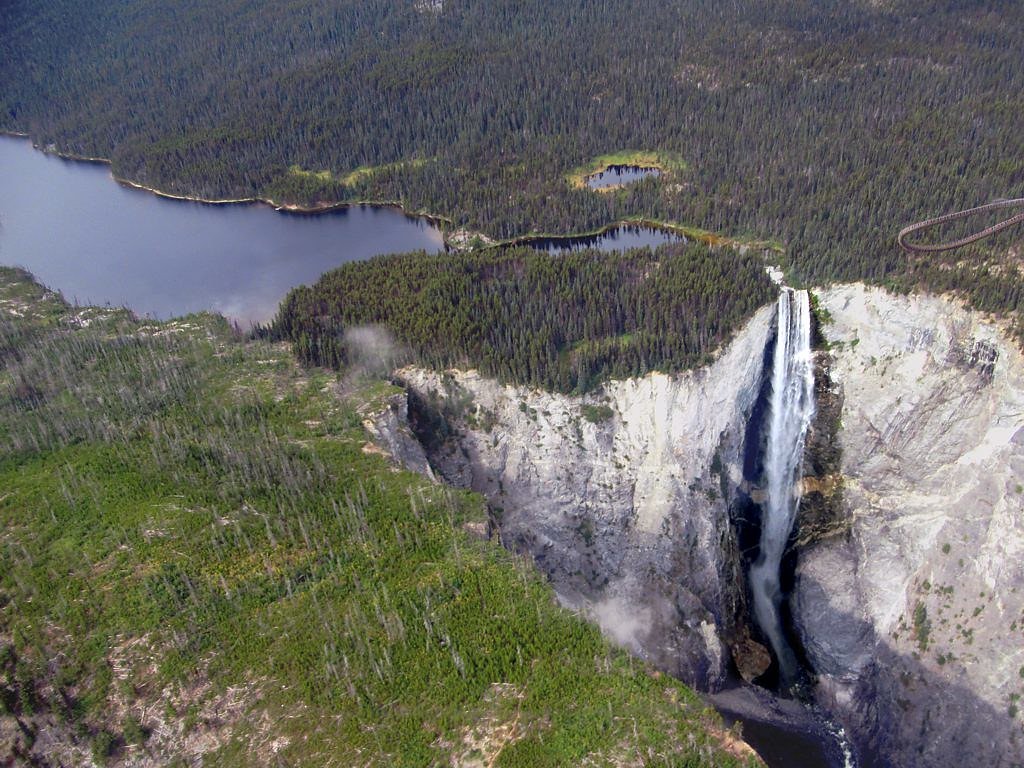
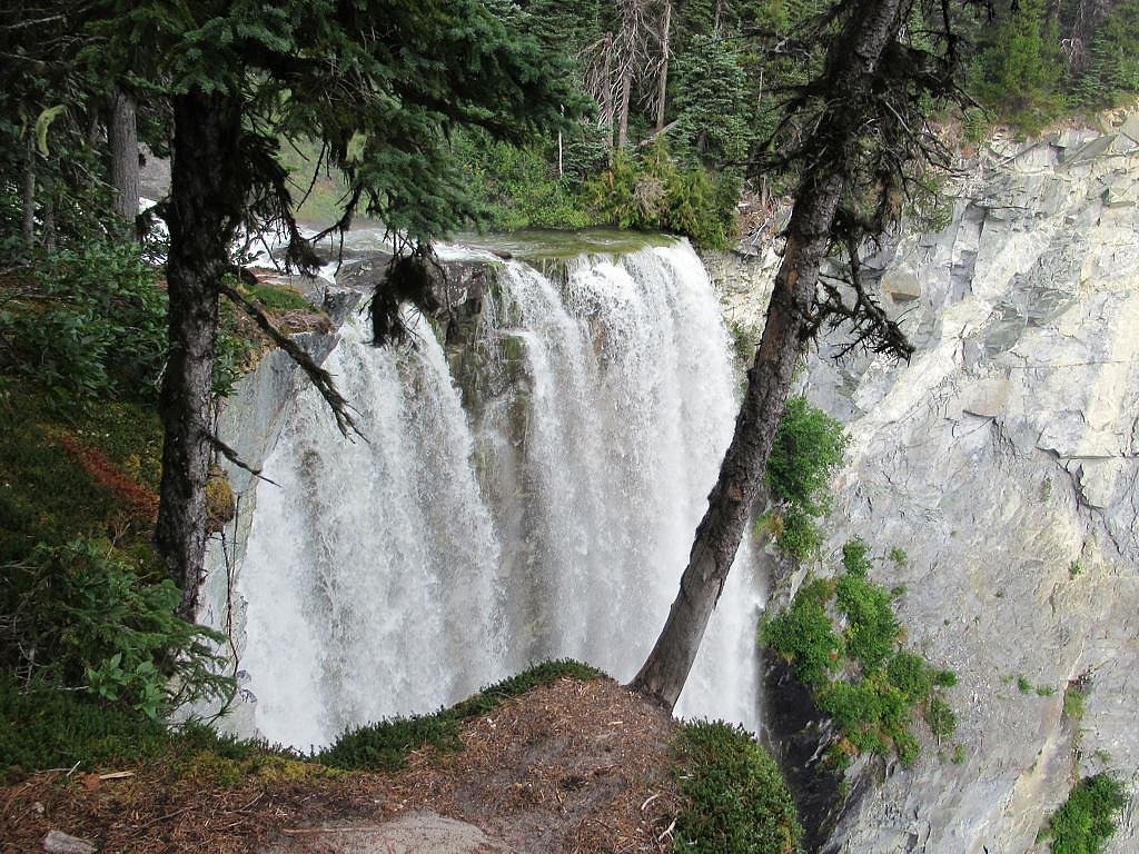
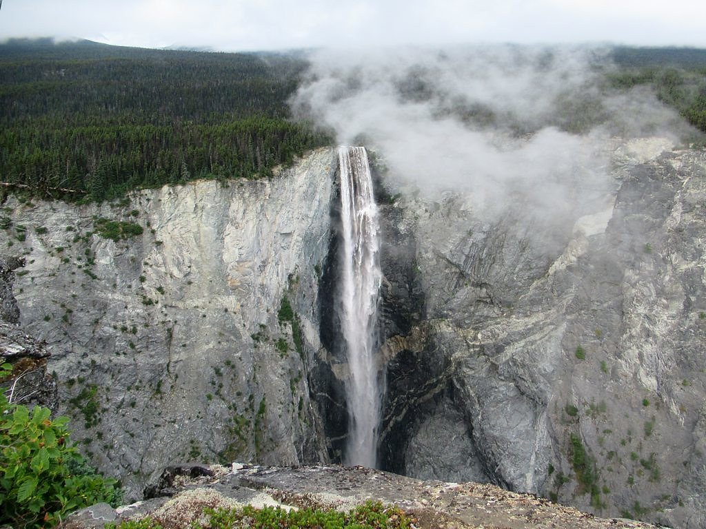

Photo Credits (4)
Difficulty
Hard
Trail Length
32.8 km
Trail Type
Out And Back
Elevation Gain
800 m
About Hunlen Falls
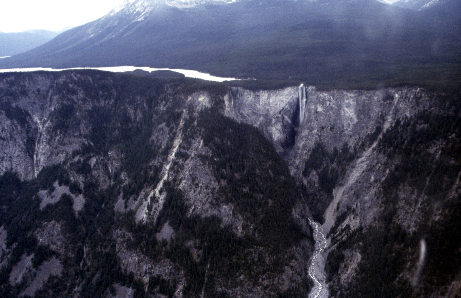
Hunlen Falls is a waterfall located at the mouth of Turner Lake in the Pacific Ranges of British Columbia, Canada. With an estimated height of 260 m (850 ft), it is tied with Takakkaw Falls in Yoho National Park for having the fourth tallest single drop of any waterfall in Canada.
The Setting
Hunlen Falls sits at 1,101 metres within Tweedsmuir Park, in the mountains of British Columbia. At 260 metres, it is among the taller waterfalls in British Columbia.
Why This Waterfall Exists
Hunlen Falls flows over hard intrusive rock laid down about 23-66 million years ago. These resistant rocks form a durable ledge that water cannot easily wear away, creating a 853-foot drop where softer material downstream has already eroded.
Trail & Hike Details
The Approach
The hard 32.8-km out-and-back trail gains 800 metres of elevation on the way to the falls.
Trail Description
Where floatplane access is used, visitors are typically dropped near Charlotte Lake and walk a short distance to a rim viewpoint overlooking the falls. Expect rough, unmaintained footpaths, possibly wet or muddy sections, and steep terrain near viewpoints. The long overland approaches are remote, may require route-finding, river crossings and backcountry camping, and are suitable only for experienced hikers.
What to Expect
The falls plunge a dramatic 260 metres over hard intrusive rock.
Accessibility
The trail involves steep, uneven terrain with significant elevation change and is not accessible to mobility devices.
Frequently Asked Questions
🐶 Are Dogs Allowed at Hunlen Falls?
❌ Dogs are not allowed
Are There Any Fees or Permits Required?
🆖 No fees required
🏊 Is There Swimming at Hunlen Falls?
❌ Swimming is not allowed
When to Visit
Late spring through early fall is the usual window for visiting. Late spring/early summer (snowmelt) often yields higher flows, while mid-summer through early fall typically offers the most reliable floatplane access and clearer weather. Winter access is very difficult and often not feasible without technical travel skills.
Seasonal Access
The best time to visit is Spring, Summer, and Fall. Winter access may be limited. Check with Tweedsmuir Park for current conditions.
Safety Information
This is remote backcountry terrain. Primary hazards include: steep cliffs and unstable edges (risk of falls), rapidly changing weather, cold water and strong currents, insect harassment (mid-summer), bear encounters, and lack of cell service or nearby emergency services. Floatplane operations have their own safety considerations (weight limits, timing, weather cancellations). Always prepare for self-rescue, carry appropriate emergency equipment, inform others of your plan, and err on the side of caution.
Current Water Conditions
49.7 m³/s
Current discharge — how much water is flowing
Higher than usual for this time of year
Based on 58 years of record
1.58 m
Water depth at gauge
7-Day Discharge Trend
What does this mean for your visit?
The water is flowing higher than usual for this time of year.
About This Gauge
This gauge is on a nearby waterway and may not reflect exact conditions at the falls.
7-Day Flow Outlook
Based on the WSC gauge ATNARKO RIVER NEAR THE MOUTH (18 km away).
Today
Strong
49 m³/s
9/10Tomorrow
Strong
48 m³/s
10/10Tue
Strong
53 m³/s
8/10Wed
Strong
49 m³/s
10/10Thu
Strong
46 m³/s
9/10Fri
Strong
44 m³/s
9/10Sat
Strong
49 m³/s
8/10Best window: Tomorrow — strong flow, mainly sunny (trip score 10/10).
Best time of year: this gauge typically runs highest from early May to late July, peaking in June.
How we calculate this
This is a transparent outlook, not a precise forecast. We take the waterfall's current flow strength (how it ranks against its historical normal for today, from the nearest WSC stream gauge), carry that ranking forward along the gauge's seasonal curve, and nudge it for forecast rain. Confidence is highest for the next day or two and falls further out. Always check official conditions and your own judgment before visiting — high flows can be dangerous.
Weather Forecast
Location & Access
Getting There
Hunlen Falls is in remote Tweedsmuir South Provincial Park. The most common visitor route is by floatplane to Charlotte Lake followed by a short walk to a viewpoint. There is also a long, remote multi-day hiking/backpacking approach from surrounding valleys and trails; roads and logging access in the area may be seasonal and unreliable. Cell service is typically non-existent. Confirm floatplane operators, park access and current conditions before travel.
Get Directions on Google MapsParking
Minimal or no formal parking at the falls. If accessing by vehicle to a trailhead or logging road, parking and road conditions may be informal and seasonal; many visitors use floatplane access and thus parking is not relevant.
Elevation
1,101 metres above sea level
Coordinates
52.276259° N, -125.771336° W
Land Management
Managed by Government of British Columbia
Visitor Tips & Gear
• Arrange floatplane service well in advance and confirm pickup windows. • Tell someone your plan and expected return; expect no cell coverage. • Pack for backcountry conditions: extra layers, rain gear, sufficient food and water, navigation tools and first aid. • Bring bear spray and know bear-safety practices. • Stay well back from cliff edges, there are cliffs, loose rock and no guardrails. • Check BC Parks and local operator notices for access, seasonal restrictions or closures.
As an Amazon Associate, we earn from qualifying purchases.
This challenging 32.8 km trail gains 800 m in elevation — come prepared with proper hiking boots and trekking poles. Sun exposure on the trail makes good sun protection a must in summer.

Sawyer Squeeze Water Filter
The backcountry standard — filters 99.9% of bacteria and weighs just 3 oz.

Polarized Sunglasses (Knockaround)
Cuts glare off the water so you actually see the falls — and your photos turn out better too.

Columbia Watertight II Rain Jacket
Packs into its own pocket, seam-sealed, and keeps you dry from spray and surprise rain.

Earth Pak Waterproof Dry Bag
Keeps your phone and gear dry when waterfall mist soaks everything else.

Waterproof Phone Pouch (AiRunTech)
Cheap insurance — take photos right next to the falls without killing your phone.

Timberland Euro Sprint Mid Waterproof
Trusted waterproof boot with premium leather and grippy rubber sole — reliable on rocky, wet trails.
Where to Stay
Browse vacation cabins and private rentals nearby
Unique outdoor stays — tents, yurts, and treehouses
Rent a campervan or RV for your waterfall road trip
Some links are affiliate links. We may earn a commission at no extra cost to you.
Nearby Campground
Tweedsmuir Wilderness Camp
0.8 km away
Additional Information
Nearby Attractions
Tweedsmuir South Provincial Park features extensive backcountry opportunities, lakes such as Charlotte Lake, wilderness rivers and remote hiking/camping. Nearby attractions are largely other backcountry destinations rather than developed tourist sites.
Wildlife
The area supports wildlife typical of central BC backcountry: black bear and grizzly bear, moose, wolves, deer, and raptors such as eagles. Practice wildlife-aware food storage and travel in groups when possible.
Writing about Hunlen Falls? Embed this waterfall on your site for free.