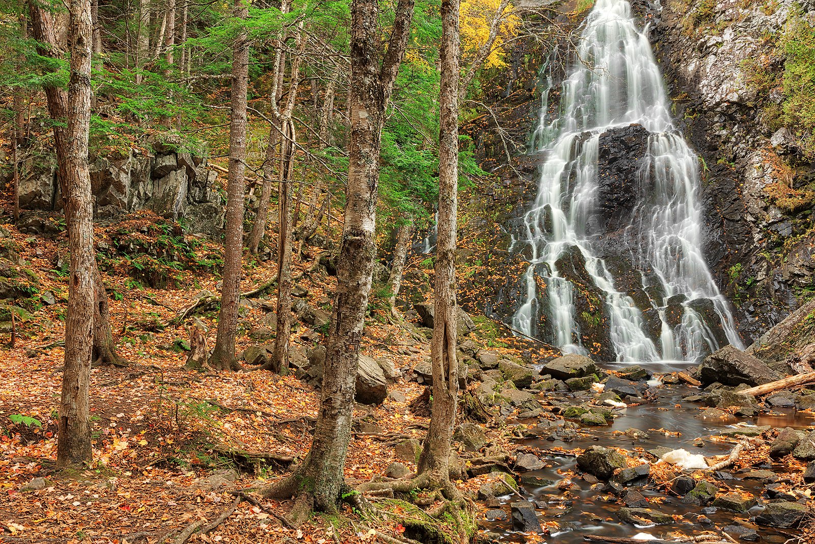
Hays Falls
New Brunswick • 20 m
By Armen Suny · Last verified Jun 2026

Photo Credits (2)
Difficulty
Moderate
Trail Length
3.2 km
Trail Type
Out And Back
Elevation Gain
98 m
About Hays Falls
Hays Falls is a small to medium-sized waterfall located in rural northwestern New Brunswick near the border region. The falls sit near coordinates 46.0263, -67.5555 and are set on a local river/stream that shows strong seasonal variation in flow. Exact height and detailed facility information are not well documented in widely available trail guides; the setting is typically forested and rustic, with natural banks and rock outcrops.
The Setting
Hays Falls sits at 139 metres within 4003000, in the coastal lowlands of New Brunswick. The falls drop 20 metres.
Why This Waterfall Exists
Hays Falls flows over layered sedimentary rock laid down about 252-539 million years ago. Over time, the stream has worn through these layers at different rates, creating a 66-foot drop that forms the waterfall.
Trail & Hike Details
The Approach
The moderate 3.2-km out-and-back trail gains 98 metres of elevation on the way to the falls.
Trail Description
Detailed, maintained trail information is not readily available from major trail databases. Approaches to the falls may consist of a short, unmaintained path from a roadside pullout or a brief walk along a forest or logging road. Expect uneven footing, roots, and rocky sections; sections near the water may be muddy or slick. If there is no clear trail, use caution when leaving the road to approach the stream.
What to Expect
The falls drop 20 metres over layered sedimentary rock.
Accessibility
The trail is not wheelchair accessible. Uneven terrain and elevation changes require steady footing.
Frequently Asked Questions
🐶 Are Dogs Allowed at Hays Falls?
❌ Dogs are not allowed
Are There Any Fees or Permits Required?
🆖 No fees required
🏊 Is There Swimming at Hays Falls?
❌ Swimming is not allowed
When to Visit
Spring often offers the most impressive flows (snowmelt and spring rains). Fall provides scenic foliage. Summer is accessible and warmer but can mean lower flows and more insects. Winter can show ice formations and a quiet setting, but access may be difficult due to snow and ice; conditions can be hazardous.
Seasonal Access
The best time to visit is Spring, Summer, Fall, and Winter. Check with the managing park or local authority for current conditions.
Safety Information
Hazards include slippery rocks and wet banks, sudden changes in water flow after rain, cold water temperatures, unstable or eroding edges, limited or no cell service, and seasonal insects. There may be logging or forestry traffic on access roads, use caution and comply with signage. If visiting in winter, expect icy, snowy, and potentially impassable roads; hypothermia risk is higher. Always exercise caution near water and avoid risky behavior such as climbing on wet rock faces or jumping into unknown pools.
Current Water Conditions
0.7 m³/s
Current discharge — how much water is flowing
About average for this time of year
Based on 103 years of record
0.40 m
Water depth at gauge
7-Day Discharge Trend
What does this mean for your visit?
Flow is about average for this time of year.
About This Gauge
This gauge is on a nearby waterway and may not reflect exact conditions at the falls.
7-Day Flow Outlook
Based on the WSC gauge SHOGOMOC STREAM NEAR TRANS CANADA HIGHWAY (20 km away).
Today
Moderate
0.7 m³/s
5/10Tomorrow
Moderate
0.7 m³/s
6/10Tue
Moderate
0.7 m³/s
6/10Wed
Moderate
0.7 m³/s
5/10Thu
Moderate
0.7 m³/s
5/10Fri
Moderate
0.6 m³/s
6/10Sat
Moderate
0.7 m³/s
5/10Best window: Tomorrow — moderate flow, cloudy (trip score 6/10).
Best time of year: this gauge typically runs highest from late March to late May, peaking in April.
How we calculate this
This is a transparent outlook, not a precise forecast. We take the waterfall's current flow strength (how it ranks against its historical normal for today, from the nearest WSC stream gauge), carry that ranking forward along the gauge's seasonal curve, and nudge it for forecast rain. Confidence is highest for the next day or two and falls further out. Always check official conditions and your own judgment before visiting — high flows can be dangerous.
Know when to go.
Get a free email alert when waterfalls near Fredericton hit peak flow. We only send when conditions are worth the trip — no weekly newsletters, no spam.
Weather Forecast
Location & Access
Getting There
Coordinates: 46.0263, -67.5555. Nearest communities include Vanceboro (~27.8 miles), Oakfield (~28.9 miles) and Island Falls (~30.9 miles). Access is likely by local paved or gravel roads and may require driving on secondary/forest roads or a short spur road. Visitors should plan to use a map or GPS coordinates and expect rural driving conditions; cell service may be limited in parts. Portions of the approach may cross or run alongside private land or forestry operations, confirm access where possible before visiting.
Get Directions on Google MapsParking
Parking is likely informal (small pullouts or roadside); there are no widely advertised formal parking lots or visitor facilities. Expect limited space and potentially soft or uneven ground. If in doubt, park well off the traveled lane and avoid blocking gates or driveways.
Elevation
139 metres above sea level
Coordinates
46.026314° N, -67.555541° W
Land Management
Managed by Forest Planning & Stewardship Branch, Department of Natural Resources and Energy Development, Government of New Brunswick
Visitor Tips & Gear
1) Tell someone your plans and expected return time; cell coverage may be unreliable. 2) Wear sturdy, waterproof footwear with good traction. 3) Avoid getting on wet rocks near the edge; they can be extremely slippery. 4) Check local forestry activity or private land notices before visiting. 5) Carry out all trash; no formal facilities are expected. 6) Be prepared for insects; bring repellent and consider long sleeves in summer.
As an Amazon Associate, we earn from qualifying purchases.
With 3.2 km and 98 m of elevation gain, sturdy boots and trekking poles will help on this moderate trail. Icy conditions are common in winter — traction cleats are a smart addition.

Columbia Watertight II Rain Jacket
Packs into its own pocket, seam-sealed, and keeps you dry from spray and surprise rain.

Polarized Sunglasses (Knockaround)
Cuts glare off the water so you actually see the falls — and your photos turn out better too.

Earth Pak Waterproof Dry Bag
Keeps your phone and gear dry when waterfall mist soaks everything else.

Waterproof Phone Pouch (AiRunTech)
Cheap insurance — take photos right next to the falls without killing your phone.

Timberland Euro Sprint Mid Waterproof
Trusted waterproof boot with premium leather and grippy rubber sole — reliable on rocky, wet trails.

TrailBuddy Trekking Poles
Lightweight aluminum, cork grips, and flip-locks that actually hold — a best-seller for good reason.
Where to Stay
Browse vacation cabins and private rentals nearby
Unique outdoor stays — tents, yurts, and treehouses
Rent a campervan or RV for your waterfall road trip
Some links are affiliate links. We may earn a commission at no extra cost to you.
Nearby Campground
Connell camp ground
15.5 km away
Additional Information
Nearby Attractions
The area is rural with access to rivers, forest roads and outdoor recreation typical of northwestern New Brunswick. Nearby communities include Vanceboro, Oakfield and Island Falls. Cross-border attractions in neighboring Maine may be within driving distance depending on route and border-crossing status.
Wildlife
Typical regional wildlife may include white-tailed deer, moose, black bear, small mammals (squirrels, hares), songbirds and waterfowl. Be aware of ticks and biting insects during warmer months.
Cities near Hays Falls
Writing about Hays Falls? Embed this waterfall on your site for free.