
Photo Credits (5)
Difficulty
Easy
Trail Length
0.4 km
Trail Type
Out And Back
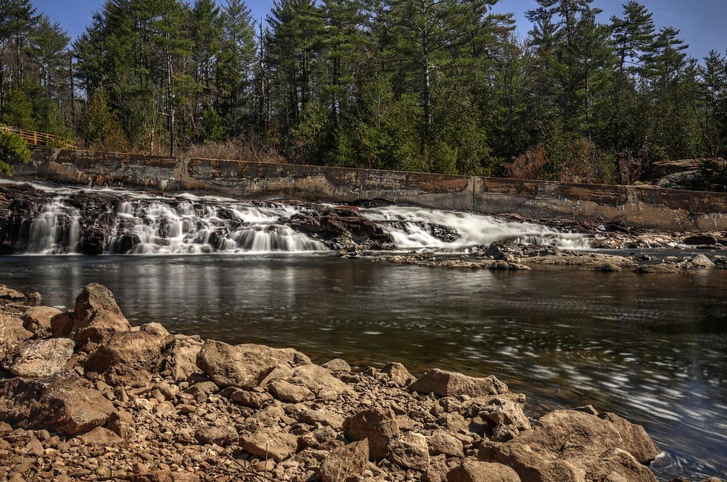
About Elliott Falls
Elliott Falls is a small to medium cascade located in south-central Ontario (coordinates: 44.7429, -78.825). The falls sit on a river/stream that cuts through a rocky, forested section of the landscape. Visitors should expect a natural, relatively undeveloped setting with rock ledges and pool areas below the falls. Specifics about the number of drops and exact measured height are not well-documented in widely available sources and may vary with seasonal flows.
Why This Waterfall Exists
Elliott Falls flows over hard crystalline rock, primarily marble, laid down over 1.0-1.6 billion years ago. These resistant rocks form a durable ledge that water cannot easily wear away, creating the falls where softer material downstream has already eroded.
Trail & Hike Details
Trail Description
There is no widely published maintained trail description from official park sources for Elliott Falls at these coordinates. Expect a short informal approach over uneven, possibly rocky forest terrain to reach river viewpoints. Trails (if present) are likely unmarked and may involve scrambling down to the water's edge. Because information is limited, plan for variable footing and limited wayfinding; bring a map/GPS and be prepared to turn back if access appears to cross private property.
What to Expect
A natural, relatively undeveloped waterfall setting with rocky banks and forest cover. Water flow and the appearance of the falls will vary seasonally: higher, more dramatic flows in spring and after rain; lower flow in late summer. There may be limited cell service, no facilities (toilets or maintained viewpoints), and potentially muddy or icy approaches depending on season. Expect insects (mosquitoes, black flies) in warm months and slippery rocks near the water.
Accessibility
The trail is short and relatively flat, but the surface may be uneven. Contact the managing agency for accessibility details.
Frequently Asked Questions
🐶 Are Dogs Allowed at Elliott Falls?
❌ Dogs are not allowed
Are There Any Fees or Permits Required?
🆖 No fees required
🏊 Is There Swimming at Elliott Falls?
❌ Swimming is not allowed
When to Visit
Spring for highest flows and dramatic water; late spring/early summer for full water and green surroundings; fall for foliage color and pleasant hiking temperatures. Winter can produce frozen cascades that are scenic but hazardous, expect very slippery conditions and limited access.
Seasonal Access
The best time to visit is Spring, Summer, Fall, and Winter. Check with the managing park or local authority for current conditions.
Safety Information
Hazards may include slippery and unstable rocks around the falls, cold water and strong currents, steep drop-offs, limited or no cell service, ticks and biting insects, and rapidly changing weather. Ice in winter can be brittle and conceal hazards; frozen waterfalls can be dangerous for close access. If visiting after heavy rain, avoid riverbanks due to high flows and possible flashier conditions. Always tell someone your plans and expected return time.
Current Water Conditions
20.2 m³/s
Current discharge — how much water is flowing
About average for this time of year
Based on 63 years of record
3.79 m
Water depth at gauge
7-Day Discharge Trend
What does this mean for your visit?
Flow is about average for this time of year.
About This Gauge
7-Day Flow Outlook
Based on the WSC gauge GULL RIVER AT NORLAND (1 km away).
Today
Moderate
20 m³/s
9/10Tomorrow
Moderate
20 m³/s
8/10Tue
Strong
22 m³/s
7/10Wed
Strong
22 m³/s
8/10Thu
Moderate
21 m³/s
8/10Fri
Moderate
22 m³/s
6/10Sat
Moderate
21 m³/s
8/10Best window: Today — moderate flow, mainly sunny (trip score 9/10).
Best time of year: this gauge typically runs highest from early December to late January, peaking in April.
How we calculate this
This is a transparent outlook, not a precise forecast. We take the waterfall's current flow strength (how it ranks against its historical normal for today, from the nearest WSC stream gauge), carry that ranking forward along the gauge's seasonal curve, and nudge it for forecast rain. Confidence is highest for the next day or two and falls further out. Always check official conditions and your own judgment before visiting — high flows can be dangerous.
Know when to go.
Get a free email alert when waterfalls near Orillia hit peak flow. We only send when conditions are worth the trip — no weekly newsletters, no spam.
Weather Forecast
Location & Access
Getting There
Use GPS coordinates 44.7429, -78.825. The falls are in a rural area roughly between Orillia (~32 miles), Peterborough (~42 miles), and Barrie (~55 miles). Access is via local secondary roads; some final approach roads may be unpaved. There is no widely published official trailhead or park lot tied to these coordinates in major provincial park guides, so plan to use local maps, recent trip reports, or a trusted GPS app to navigate.
Get Directions on Google MapsParking
There may be limited or informal roadside parking near the access point. There is no confirmed official parking lot; park legally, avoid blocking driveways/roads, and expect a short walk from wherever you can leave your vehicle. If parking on a shoulder, use caution and be visible.
Elevation
272 metres above sea level
Coordinates
44.742949° N, -78.824985° W
Visitor Tips & Gear
• Use the provided coordinates and local maps; recent trip reports or local hiking forums can provide up-to-date access notes. • Wear sturdy footwear with good traction; the approach is likely uneven and may require light scrambling. • Do not assume formal parking, signs, or maintained trails, park legally and consider car security. • Check private property boundaries and posted signs: some water-access routes in Ontario cross private land. • Bring water, snacks, and a small first-aid kit. In winter, bring traction devices and warm layers. • Leave no trace: pack out trash and avoid disturbing vegetation or wildlife.
Where to Stay
Browse vacation cabins and private rentals nearby
Unique outdoor stays — tents, yurts, and treehouses
Rent a campervan or RV for your waterfall road trip
Some links are affiliate links. We may earn a commission at no extra cost to you.
Nearby Campground
Site 64
5.7 km away
Additional Information
Nearby Attractions
Nearest population centers include Orillia, Peterborough, and Barrie. The broader region offers lakes, provincial parks, and recreational areas typical of central Ontario (lakes, boating, hiking). For specific nearby parks or attractions consult regional tourism or provincial park resources based on your travel route.
Wildlife
Typical southern Ontario wildlife: white-tailed deer, beavers, raccoons, small mammals, numerous songbirds, waterfowl, and insects. Ticks (Lyme disease risk) and mosquitoes can be common in spring and summer. Black bears are possible in parts of Ontario but are typically uncommon in more populated lake-country areas, still exercise standard wildlife caution.
Cities near Elliott Falls
Writing about Elliott Falls? Embed this waterfall on your site for free.