Photo Credits (1)
Difficulty
Moderate
Trail Length
7.4 km
Trail Type
Out And Back
Elevation Gain
353 m
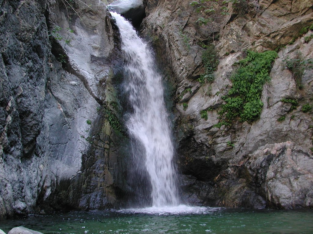
About Eaton Falls
Eaton Falls (coordinates 53.825, -119.2072) is a remote waterfall feature located near the Alberta–British Columbia border in northeastern British Columbia / western Alberta region. Exact administrative jurisdiction is uncertain based on the coordinates provided. The falls sit in a largely forested, backcountry setting and are best known to local hikers and forestry workers rather than being a developed park attraction. Accessibility is typically via secondary/forestry roads and a short to moderate hike or bushwhack from a roadside pullout. Seasonal flow varies: highest in spring snowmelt and after heavy rain, lower in late summer and frozen or partially frozen in winter.
The Setting
Eaton Falls sits at 1,065 metres within Willmore Wilderness Park, in the mountains of Alberta.
Why This Waterfall Exists
Eaton Falls flows over Fernie Formation; Nikanassin Formation, a layered sedimentary rock layer deposited about 101-201 million years ago. These soft rocks erode readily, allowing the stream to carve a vertical drop into the landscape.
Trail & Hike Details
The Approach
The moderate 7.4-km out-and-back trail gains 353 metres of elevation on the way to the falls.
Trail Description
Approach routes vary and are often a mix of short trail sections and unmaintained bushwhacking. Trails, if present, can be faint and may cross uneven, rooty terrain and rocky creek banks. Expect wet, muddy ground in spring and slippery surfaces near the falls. The final descent to a viewpoint may be steep with loose rock. Because official maintained trails and signage appear to be minimal or absent, plan for route-finding and basic backcountry navigation.
What to Expect
A remote, natural waterfall in a forested canyon or creek corridor. The falls may be multi-tiered or a single drop depending on the exact channel at the coordinates; water volume is seasonal and can be substantial during spring melt. There are likely no facilities (no restrooms, no guardrails, no official viewpoints). Wildlife such as deer, moose, and occasionally bears or cougars may inhabit the area. Expect uneven footing, exposed roots, mud, and slippery rocks near water.
Accessibility
The trail involves steep, uneven terrain with significant elevation change and is not accessible to mobility devices.
Frequently Asked Questions
🐶 Are Dogs Allowed at Eaton Falls?
❌ Dogs are not allowed
Are There Any Fees or Permits Required?
🆖 No fees required
🏊 Is There Swimming at Eaton Falls?
❌ Swimming is not allowed
When to Visit
Late spring (snowmelt) for highest flows and good scenery; early summer for milder weather and fewer stream crossings. Fall can offer lower flows with good foliage color but shorter daylight. Winter visits are possible but access may be limited by snow; ice hazards and very slick conditions near frozen waterfalls make winter visits more hazardous.
Seasonal Access
The best time to visit is Spring, Summer, Fall, and Winter. Check with the managing park or local authority for current conditions.
Safety Information
Hazards include slippery rocks and steep, unstable edges near the waterfall, potential for flashy water conditions during heavy rain or spring melt, river or creek crossings, limited or no cell service, rough forestry roads, and wildlife encounters. In winter, ice and deep snow increase risk. No formal rescue services may be immediately available. Use caution, travel with partners when possible, and prepare for backcountry conditions.
Current Water Conditions
262.0 m³/s
Current discharge — how much water is flowing
Higher than usual for this time of year
Based on 57 years of record
2.59 m
Water depth at gauge
7-Day Discharge Trend
What does this mean for your visit?
The water is flowing higher than usual for this time of year.
About This Gauge
This gauge is on a nearby waterway and may not reflect exact conditions at the falls.
7-Day Flow Outlook
Based on the WSC gauge SMOKY RIVER ABOVE HELLS CREEK (14 km away).
Today
Roaring
283 m³/s
6/10Tomorrow
Roaring
289 m³/s
6/10Tue
Roaring
270 m³/s
6/10Wed
Roaring
242 m³/s
9/10Thu
Strong
234 m³/s
9/10Fri
Strong
244 m³/s
10/10Sat
Roaring
260 m³/s
6/10Best window: Fri — strong flow, sunny (trip score 10/10).
Best time of year: this gauge typically runs highest from mid May to mid August, peaking in June.
How we calculate this
This is a transparent outlook, not a precise forecast. We take the waterfall's current flow strength (how it ranks against its historical normal for today, from the nearest WSC stream gauge), carry that ranking forward along the gauge's seasonal curve, and nudge it for forecast rain. Confidence is highest for the next day or two and falls further out. Always check official conditions and your own judgment before visiting — high flows can be dangerous.
Weather Forecast
Location & Access
Getting There
The falls are in a remote area accessible primarily by gravel/forestry roads off the main regional highways. Expect long stretches of unpaved road; a high-clearance vehicle is often recommended. There may be no formal trailhead signage; navigation by GPS coordinates, topographic map, or local route descriptions is recommended. Cell phone reception may be limited or absent.
Get Directions on Google MapsParking
Parking is likely informal, a roadside pullout or small cleared area. There may be no developed parking lot, signage, or facilities. Park clear of any gates or private driveways and avoid blocking logging traffic.
Elevation
1,065 metres above sea level
Coordinates
53.824975° N, -119.207177° W
Land Management
Managed by Lands Operations Division, Alberta Forestry and Parks
Visitor Tips & Gear
• Use a detailed map and download offline maps; GPS coordinates are recommended. • Bring a high-clearance vehicle and be prepared for rough gravel/forestry roads; consider parking earlier and hiking in if roads are poor. • Wear sturdy hiking boots with good traction and bring trekking poles for steep or slippery sections. • Check local forest service or regional municipality notices for road closures, logging activity, or seasonal restrictions. • Tell someone your route and expected return time, there may be no cell service. • Respect private land and posted signs; obtain permission if access crosses private property. • Avoid approaching cliff edges and slippery rocks near the lip of the falls.
As an Amazon Associate, we earn from qualifying purchases.
With 7.4 km and 353 m of elevation gain, sturdy boots and trekking poles will help on this moderate trail. Icy conditions are common in winter — traction cleats are a smart addition.

Columbia Watertight II Rain Jacket
Packs into its own pocket, seam-sealed, and keeps you dry from spray and surprise rain.

Polarized Sunglasses (Knockaround)
Cuts glare off the water so you actually see the falls — and your photos turn out better too.

Earth Pak Waterproof Dry Bag
Keeps your phone and gear dry when waterfall mist soaks everything else.

Waterproof Phone Pouch (AiRunTech)
Cheap insurance — take photos right next to the falls without killing your phone.

Timberland Euro Sprint Mid Waterproof
Trusted waterproof boot with premium leather and grippy rubber sole — reliable on rocky, wet trails.

TrailBuddy Trekking Poles
Lightweight aluminum, cork grips, and flip-locks that actually hold — a best-seller for good reason.
Where to Stay
Browse vacation cabins and private rentals nearby
Unique outdoor stays — tents, yurts, and treehouses
Rent a campervan or RV for your waterfall road trip
Some links are affiliate links. We may earn a commission at no extra cost to you.
Nearby Campground
Kvass Flats
2.1 km away
Additional Information
Nearby Attractions
Nearby attractions are not definitively documented for this exact coordinate. The broader region (northeastern British Columbia/western Alberta) may have other natural features such as additional waterfalls, hiking routes, rivers, and provincial or regional parks, check local visitor information for nearby developed attractions and trails.
Wildlife
Typical boreal/montane wildlife may include black bears, moose, deer, small mammals, and a variety of birds. Mosquitoes and biting insects can be significant in spring/summer. Practice standard wildlife safety: store food securely and keep distance from animals.
Writing about Eaton Falls? Embed this waterfall on your site for free.