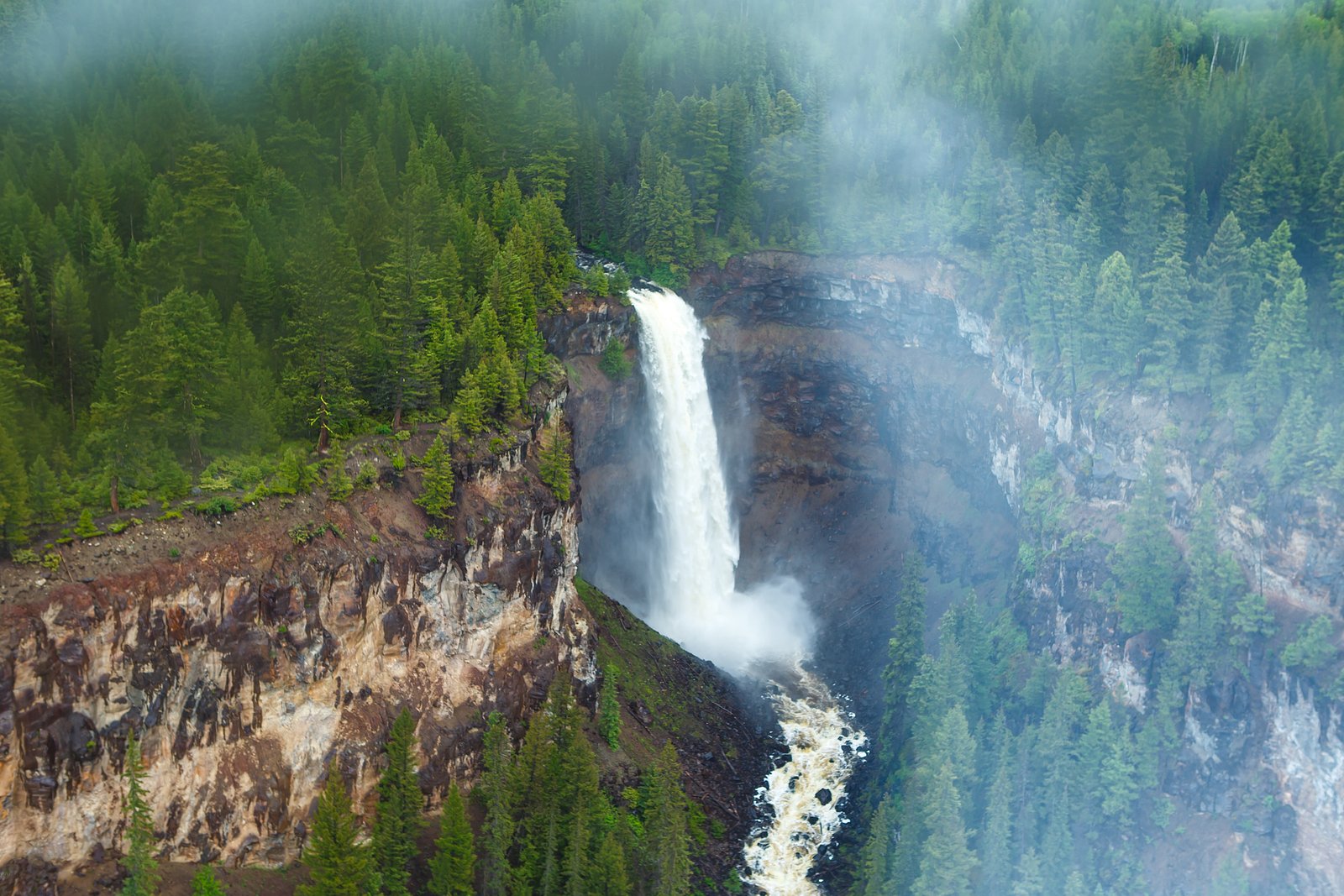
Deadman Falls
By Armen Suny · Last verified Jun 2026
Photo Credits (1)
Difficulty
Drive Up
Trail Length
0.2 km
About Deadman Falls
Deadman Falls is a small cascade in the interior of British Columbia near the Deadman River valley. The falls sit in a forested, largely undeveloped setting and are most notable for seasonal flows (highest in spring snowmelt). Access appears to be via local/forestry roads with a short unmaintained approach; viewpoints are natural rather than developed. Specifics about official facilities and infrastructure are limited and reports indicate the site is more of a low-key, local waterfall rather than a managed tourist attraction.
Why This Waterfall Exists
Deadman Falls flows over hard volcanic rock laid down about 3-23 million years ago. These resistant rocks form a durable ledge that water cannot easily wear away, creating the falls where softer material downstream has already eroded.
Trail & Hike Details
The Approach
No hiking required. Deadman Falls is accessible by vehicle with a roadside viewing area.
Trail Description
Reports indicate a short, unmaintained approach from a roadside parking area or pullout. The path to viewing points may be faint, steep in places, and could require scrambling over roots and rocks. Trails and viewpoints are natural (no boardwalks or viewing platforms). Expect limited signage and little to no infrastructure; navigation by map or GPS and route-finding experience are helpful.
What to Expect
A forested setting with a small to moderate cascade on a local stream or tributary (flow varies by season). High water in spring from snowmelt produces the most impressive flows; late summer may be lower. Little to no facilities (no toilets, trash service, or visitor center). Terrain may be rocky and wet near the pool and on the approach. Cell service may be intermittent or absent.
Accessibility
This waterfall is viewable from a vehicle-accessible area. No hiking is required.
Frequently Asked Questions
🐶 Are Dogs Allowed at Deadman Falls?
❌ Dogs are not allowed
Are There Any Fees or Permits Required?
🆖 No fees required
🏊 Is There Swimming at Deadman Falls?
❌ Swimming is not allowed
When to Visit
Late spring (snowmelt) for peak flows and wildflowers; early to mid-summer for easier, drier access; early fall for color and lower water levels. Winter access may be difficult or hazardous due to snow and ice.
Seasonal Access
The best time to visit is Spring, Summer, and Fall. Winter access may be limited. Check with the managing park or local authority for current conditions.
Safety Information
Hazards may include slippery and unstable rocks, steep or loose slopes, high water and strong currents during spring runoff, falling rock, limited or no cell service, and remoteness (delayed emergency response). Carry appropriate gear, tell someone your plans, and avoid risky river crossings. Check current conditions and local advisories before visiting.
Current Water Conditions
0.0 m³/s
Current discharge — how much water is flowing
Much lower than usual for this time of year
Based on 39 years of record
2.27 m
Water depth at gauge
7-Day Discharge Trend
What does this mean for your visit?
Flow is well below normal for this time of year, so the waterfall may be a trickle.
About This Gauge
7-Day Flow Outlook
Based on the WSC gauge JOE ROSS CREEK NEAR THE MOUTH (0 km away).
Today
Barely Flowing
0.0 m³/s
3/10Tomorrow
Barely Flowing
0.0 m³/s
4/10Tue
Barely Flowing
0.0 m³/s
3/10Wed
Barely Flowing
0.0 m³/s
4/10Thu
Barely Flowing
0.0 m³/s
3/10Fri
Low
0.0 m³/s
3/10Sat
Low
0.0 m³/s
4/10Best window: Tomorrow — barely flowing flow, cloudy (trip score 4/10).
Best time of year: this gauge typically runs highest from early April to mid May, peaking in May.
How we calculate this
This is a transparent outlook, not a precise forecast. We take the waterfall's current flow strength (how it ranks against its historical normal for today, from the nearest WSC stream gauge), carry that ranking forward along the gauge's seasonal curve, and nudge it for forecast rain. Confidence is highest for the next day or two and falls further out. Always check official conditions and your own judgment before visiting — high flows can be dangerous.
Know when to go.
Get a free email alert when waterfalls near Kamloops hit peak flow. We only send when conditions are worth the trip — no weekly newsletters, no spam.
Weather Forecast
Location & Access
Getting There
The waterfall is located near coordinates 51.1513, -120.862, in the interior of British Columbia. The nearest larger communities are Kamloops (approx. 46 miles) and Lillooet (approx. 68 miles). Expect to reach the general area from the nearest highway, then follow local or forest service roads; the last segment may be unpaved and rough. A GPS device or offline map and up-to-date local road/forest service status are recommended. Check local sources (BC Parks or regional district) for seasonal road closures.
Get Directions on Google MapsParking
Parking is likely informal (roadside pullout or small unimproved parking area). Space may be limited and surfaces may be gravel or dirt. Park clear of gates/private driveways and obey any posted signs.
Elevation
1,053 metres above sea level
Coordinates
51.151324° N, -120.862037° W
Visitor Tips & Gear
• Wear sturdy, grippy footwear, approaches and rocks near the water can be slippery. • Expect no services: carry water, snacks, and a small first-aid kit. • Use a map/GPS and check local forestry/road conditions before driving unpaved roads. • Park considerately and avoid blocking gates or driveways. • Practice Leave No Trace: pack out everything you bring in. • Be cautious near the water and do not stand on wet, mossy rocks. • Check the season and recent visitor reports (if available) for trail and road conditions.
Where to Stay
Browse vacation cabins and private rentals nearby
Unique outdoor stays — tents, yurts, and treehouses
Rent a campervan or RV for your waterfall road trip
Some links are affiliate links. We may earn a commission at no extra cost to you.
Nearby Campground
Snohoosh Lake North Recreation Site
6.3 km away
Additional Information
Nearby Attractions
Nearest larger centers: Kamloops (approx. 46 miles) and Lillooet (approx. 68 miles). The surrounding region offers other outdoor recreation opportunities (forestry roads, hiking, fishing), check local tourism and park resources for nearby lakes, provincial parks, and trails.
Wildlife
Typical interior BC wildlife may include black bears, deer, elk, cougars, small mammals, and a variety of birds. Practice wildlife safety and store food properly.
Cities near Deadman Falls
Other waterfalls named Deadman Falls
2 other waterfalls share this name across Canada.
Writing about Deadman Falls? Embed this waterfall on your site for free.