Davidson's Brook Falls
By Armen Suny · Last verified Jun 2026
Difficulty
Moderate
Trail Length
0.5 km
Trail Type
Out And Back
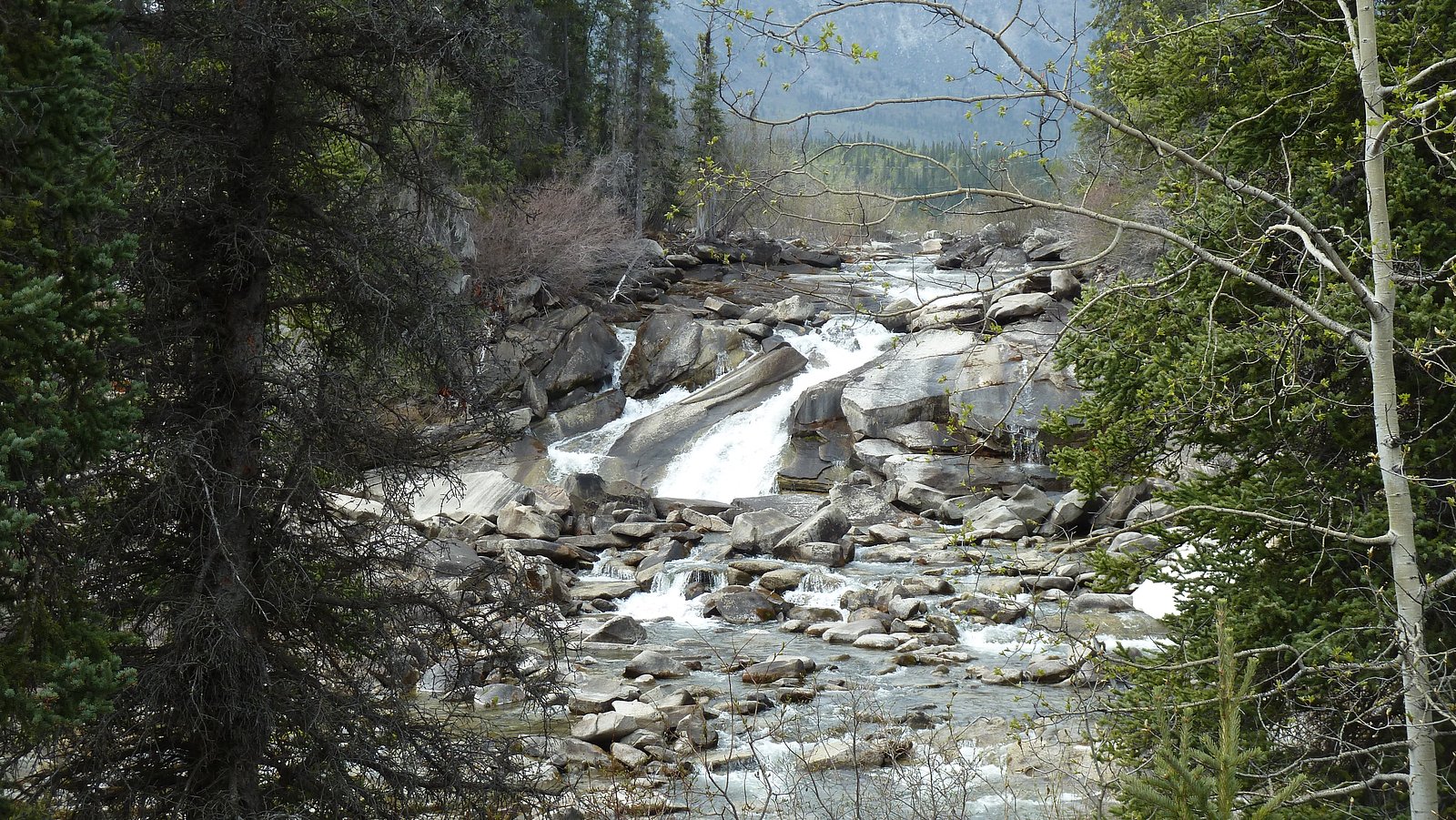
About Davidson's Brook Falls
Davidson's Brook Falls is a small, forested cascade on Davidson Brook in Nova Scotia, located roughly 6.7 miles from Halifax and about 44.8 miles from Windsor (coordinates ~44.5511, -63.556). The falls are typically a multi-tiered, scenic drop set in mixed Acadian forest. Flow can be highly seasonal, higher in spring and after rain, lower in late summer. There are limited developed facilities; access is likely via a short, informal trail or roadside pullout. Specific historical or interpretive information is limited and details below are stated conservatively where sources are not definitive.
Nearby Falls Worth Visiting
Beaverdam Brook Falls (5 m) lies 11.1 kilometres to the northwest.
Trail & Hike Details
Trail Description
Expect a short, forested walk from an informal parking/pullout. The path may be narrow, partly overgrown, and include rocks, roots, and damp sections. There may be no formal boardwalks, railings, or viewing platforms. Footing can be slippery near the brook and on any exposed rock ledges. The trail is likely under 2 miles round-trip, but exact length and maintenance level are not well documented.
What to Expect
A modest woodland waterfall with variable flow. Spring melt and heavy rains produce the most impressive flows; late summer may be a trickle. The setting is typically quiet and natural with mixed hardwood and softwood forest. Little to no developed visitor infrastructure (no restrooms, visitor center, or maintained picnic areas). Cell service may be spotty depending on provider.
Accessibility
The trail is not wheelchair accessible. Uneven terrain and elevation changes require steady footing.
Frequently Asked Questions
🐶 Are Dogs Allowed at Davidson's Brook Falls?
❌ Dogs are not allowed
Are There Any Fees or Permits Required?
🆖 No fees required
🏊 Is There Swimming at Davidson's Brook Falls?
❌ Swimming is not allowed
When to Visit
Spring (snowmelt and seasonal rains) for highest flows and early fall for foliage color are generally the best times. Summer offers warmer weather but lower flows. Winter can produce dramatic ice features but can be hazardous due to ice and limited access, use caution.
Seasonal Access
The best time to visit is Spring, Summer, Fall, and Winter. Check with the managing park or local authority for current conditions.
Safety Information
• Rocks and riverbanks around waterfalls can be extremely slippery, maintain a safe distance from edges. • Water can be cold and currents stronger than they appear; do not underestimate the water. • Watch for changing conditions after heavy rain (higher flow, flooded trails). • Cell coverage may be limited; let someone know your plans if heading into less-traveled areas. • Be mindful of seasonal hazards: ice in winter and ticks in warmer months. • Respect private property and posted signs; some approach routes may be adjacent to or cross private land.
Current Water Conditions
0.7 m³/s
Current discharge — how much water is flowing
About average for this time of year
Based on 57 years of record
0.55 m
Water depth at gauge
7-Day Discharge Trend
What does this mean for your visit?
Flow is about average for this time of year.
About This Gauge
This gauge is on a nearby waterway and may not reflect exact conditions at the falls.
7-Day Flow Outlook
Based on the WSC gauge SACKVILLE RIVER AT BEDFORD (22 km away).
Today
Moderate
0.8 m³/s
6/10Tomorrow
Moderate
0.7 m³/s
8/10Tue
Moderate
0.6 m³/s
6/10Wed
Moderate
0.8 m³/s
6/10Thu
Moderate
0.8 m³/s
6/10Fri
Moderate
0.7 m³/s
6/10Sat
Moderate
0.6 m³/s
6/10Best window: Tomorrow — moderate flow, mainly sunny (trip score 8/10).
Best time of year: this gauge typically runs highest from mid March to early May, peaking in April.
How we calculate this
This is a transparent outlook, not a precise forecast. We take the waterfall's current flow strength (how it ranks against its historical normal for today, from the nearest WSC stream gauge), carry that ranking forward along the gauge's seasonal curve, and nudge it for forecast rain. Confidence is highest for the next day or two and falls further out. Always check official conditions and your own judgment before visiting — high flows can be dangerous.
Know when to go.
Get a free email alert when waterfalls near Halifax hit peak flow. We only send when conditions are worth the trip — no weekly newsletters, no spam.
Weather Forecast
Location & Access
Getting There
The falls are located at approximately 44.5511 N, -63.556 W. From Halifax (roughly 6.7 miles away) or from Windsor (roughly 44.8 miles), drive to the local access road nearest Davidson Brook. Access is most commonly by car to a nearby pullout or small parking area, then a short walk on an unpaved or informal footpath. Exact turn-by-turn directions and road names may vary by approach; consult local maps or authorities before travelling.
Get Directions on Google MapsParking
Parking is likely informal (small roadside pullout or shoulder). There may be no formal parking lot, signage, or facilities. Park legally and avoid blocking private driveways or the roadway.
Elevation
29 metres above sea level
Coordinates
44.551138° N, -63.555963° W
Visitor Tips & Gear
• Wear sturdy, grippy footwear, rocks and roots can be slippery. • Expect muddy or wet trail conditions after rain. • Stay off wet rock ledges and avoid getting too close to the water edge, currents and undercut banks can be hazardous. • Pack out all trash; there may be no trash service. • Check local signage and respect private property; some access points may cross or be near private land. • Bring insect repellent in spring/summer and check for ticks after visiting.
Where to Stay
Browse vacation cabins and private rentals nearby
Unique outdoor stays — tents, yurts, and treehouses
Rent a campervan or RV for your waterfall road trip
Some links are affiliate links. We may earn a commission at no extra cost to you.
Nearby Campground
Bayside Camp and Retreat Centre
5.8 km away
Additional Information
Nearby Attractions
Halifax (urban amenities and waterfront attractions) is the closest major center. Other regional outdoor opportunities include local provincial parks, coastal beaches, and forested trails in the Halifax region and Hants County. Exact nearby named attractions should be confirmed with local visitor information.
Wildlife
Typical Nova Scotia woodland wildlife: songbirds, wild turkey, white-tailed deer, small mammals, and occasionally black bears. Insects such as mosquitoes and ticks are common in spring and summer; take appropriate precautions.
Cities near Davidson's Brook Falls
Nearby Waterfalls

Writing about Davidson's Brook Falls? Embed this waterfall on your site for free.