Photo Credits (3)
Difficulty
Hard
Trail Length
5.0 km
Trail Type
Out And Back
Elevation Gain
483 m
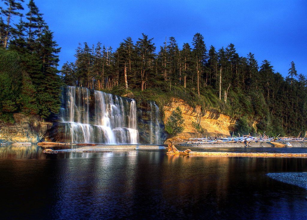
About Cliff Lake Falls
Cliff Lake Falls is an outflow cascade associated with Cliff Lake in the East Kootenay region of southeastern British Columbia. The falls sit in a remote, forested setting roughly 21 miles from Cranbrook and about 39.9 miles from West Kootenai (coordinates: 49.629, -115.399). Published, detailed trail information is limited; descriptions below are based on regional maps, common visitor reports for similar lake outflows in the area, and provincial backcountry access patterns. Specifics (height, trail length, official access) are not widely documented and so are indicated as uncertain where appropriate.
Why This Waterfall Exists
Cliff Lake Falls flows over Purcell Group, a hard volcanic rock layer deposited over 1.0-1.6 billion years ago. The softer shale and siltstone erodes faster than the resistant volcanic rocks and mafic, creating a ledge that the water plunges over.
Trail & Hike Details
The Approach
The hard 5.0-km out-and-back trail gains 483 metres of elevation on the way to the falls.
Trail Description
There is limited authoritative trail information for Cliff Lake Falls. Approaches to similar lake outflows in this region are often short but unmaintained, may involve walking along or down from a forest service road, and can include uneven, rocky, or muddy terrain and occasional bushwhacking. Visitors should expect minimal to no formal trail infrastructure (no boardwalks or built viewing platforms). If a mapped trail exists it may be a short out-and-back route; if not, reach the falls by following the lake's outflow channel from the nearest drivable access point.
What to Expect
Expect a forested backcountry setting and a cascade or series of drops where the lake drains. Flow will be highest in spring and early summer from snowmelt and lower in late summer and fall. Rocks around the falls are likely slippery and mossy; cliffs and steep banks may be present. There is likely limited cell service and few amenities (no toilets or water). Wildlife (including large mammals) may be active in the area.
Accessibility
The trail involves steep, uneven terrain with significant elevation change and is not accessible to mobility devices.
Frequently Asked Questions
🐶 Are Dogs Allowed at Cliff Lake Falls?
❌ Dogs are not allowed
Are There Any Fees or Permits Required?
🆖 No fees required
🏊 Is There Swimming at Cliff Lake Falls?
❌ Swimming is not allowed
When to Visit
Spring to early summer for the fullest flows (snowmelt). Summer for easier road access and warmer weather. Fall for lower crowds and fall color but possibly lower flow. Winter access may be difficult or unsafe due to snow and ice; frozen falls and icy conditions present hazards.
Seasonal Access
The best time to visit is Spring, Summer, Fall, and Winter. Check with the managing park or local authority for current conditions.
Safety Information
Hazards may include slippery rocks and wet surfaces near the falls, steep drop-offs, rapidly changing weather, and limited cell coverage. In winter, ice and deep snow increase risk. Forest service roads may be rough or closed seasonally; drive carefully and check road conditions. Always let someone know your route and expected return, carry navigation and emergency gear, and avoid cliff edges and unstable rock. If unsure about route-finding, consider a guide or visiting with someone experienced in local backcountry travel.
Current Water Conditions
31.6 m³/s
Current discharge — how much water is flowing
About average for this time of year
Based on 107 years of record
1.61 m
Water depth at gauge
7-Day Discharge Trend
What does this mean for your visit?
Flow is about average for this time of year.
About This Gauge
This gauge is on a nearby waterway and may not reflect exact conditions at the falls.
7-Day Flow Outlook
Based on the WSC gauge BULL RIVER NEAR WARDNER (15 km away).
Today
Moderate
32 m³/s
6/10Tomorrow
Moderate
31 m³/s
6/10Wed
Moderate
29 m³/s
6/10Thu
Moderate
31 m³/s
5/10Fri
Moderate
32 m³/s
5/10Sat
Moderate
28 m³/s
8/10Sun
Moderate
26 m³/s
6/10Best window: Sat — moderate flow, sunny (trip score 8/10).
Best time of year: this gauge typically runs highest from late April to late July, peaking in June.
How we calculate this
This is a transparent outlook, not a precise forecast. We take the waterfall's current flow strength (how it ranks against its historical normal for today, from the nearest WSC stream gauge), carry that ranking forward along the gauge's seasonal curve, and nudge it for forecast rain. Confidence is highest for the next day or two and falls further out. Always check official conditions and your own judgment before visiting — high flows can be dangerous.
Know when to go.
Get a free email alert when waterfalls near Cranbrook hit peak flow. We only send when conditions are worth the trip — no weekly newsletters, no spam.
Weather Forecast
Location & Access
Getting There
Located at 49.629, -115.399 in the Kootenay region. The nearest service town is Cranbrook (~21 miles). Access is typically by provincial or forest service roads branching off regional highways; the final approach may be on unpaved logging/FS roads. A high-clearance vehicle may be helpful. Because official approach routes are not well documented, check local maps and recent trip reports before travel, and expect limited signage and cell coverage.
Get Directions on Google MapsParking
No widely published formal parking lot is documented. Expect a roadside pullout or small informal parking area near a forest service or logging road. Parking conditions may be seasonal and muddy; park off the road fully and follow local rules.
Elevation
1,820 metres above sea level
Coordinates
49.628968° N, -115.398985° W
Visitor Tips & Gear
1) Research recent trip reports (AllTrails, local hiking forums, regional park resources) and check for any forest road notices before heading out. 2) Use a detailed topographic map or GPS; download maps for offline use. 3) Wear sturdy boots and be prepared for uneven, wet, or muddy footing. 4) Bring layers and rain gear; mountain weather can change rapidly. 5) Practice Leave No Trace; pack out all waste. 6) If travelling on forest service roads, check for vehicle restrictions and seasonal closures; a high-clearance vehicle may be needed. 7) Be bear-aware: carry bear spray and know how to use it.
This trail sits at 5,971 ft above sea level
Elevated TrailUV radiation is roughly 24% stronger at this elevation than at sea level, and the dry air accelerates dehydration. Extra sun protection and fluids go a long way.
As an Amazon Associate, we earn from qualifying purchases.

Coppertone Sport SPF 50 Sunscreen
UV intensity jumps ~4% per 1,000 ft — at this elevation you can burn in half the time.

Sun Bum SPF 30 Lip Balm (3-Pack)
Lips have almost no natural UV protection and burn fast in thin, dry mountain air.

Liquid I.V. Electrolyte Packets
You lose moisture ~2x faster at elevation — electrolytes help you absorb water efficiently.

ROCKNIGHT Polarized UV400 Sunglasses
High-altitude glare off rock and water is intense — UV400 lenses block 99%+ of UVA/UVB.
As an Amazon Associate, we earn from qualifying purchases.
This challenging 5.0 km trail gains 483 m in elevation — come prepared with proper hiking boots and trekking poles. Icy conditions are common in winter — traction cleats are a smart addition.

Columbia Watertight II Rain Jacket
Packs into its own pocket, seam-sealed, and keeps you dry from spray and surprise rain.

Sawyer Squeeze Water Filter
The backcountry standard — filters 99.9% of bacteria and weighs just 3 oz.

Polarized Sunglasses (Knockaround)
Cuts glare off the water so you actually see the falls — and your photos turn out better too.

Earth Pak Waterproof Dry Bag
Keeps your phone and gear dry when waterfall mist soaks everything else.

Waterproof Phone Pouch (AiRunTech)
Cheap insurance — take photos right next to the falls without killing your phone.

Timberland Euro Sprint Mid Waterproof
Trusted waterproof boot with premium leather and grippy rubber sole — reliable on rocky, wet trails.
Where to Stay
Browse vacation cabins and private rentals nearby
Unique outdoor stays — tents, yurts, and treehouses
Rent a campervan or RV for your waterfall road trip
Some links are affiliate links. We may earn a commission at no extra cost to you.
Nearby Campground
Norbury Lake Campground
12.1 km away
Additional Information
Nearby Attractions
Cranbrook (services and attractions) is the nearest town. The broader East Kootenay region offers lakes, provincial parks, and backcountry trails; specific nearby attractions should be confirmed on regional tourism or park sites.
Wildlife
Area may support black bears, deer, moose, cougars, small mammals, and a variety of birds. Standard wildlife precautions are advised.
Cities near Cliff Lake Falls
Writing about Cliff Lake Falls? Embed this waterfall on your site for free.