
Clayton Falls
By Armen Suny · Last verified Jun 2026
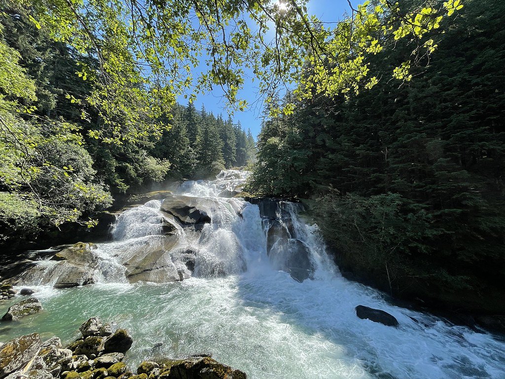
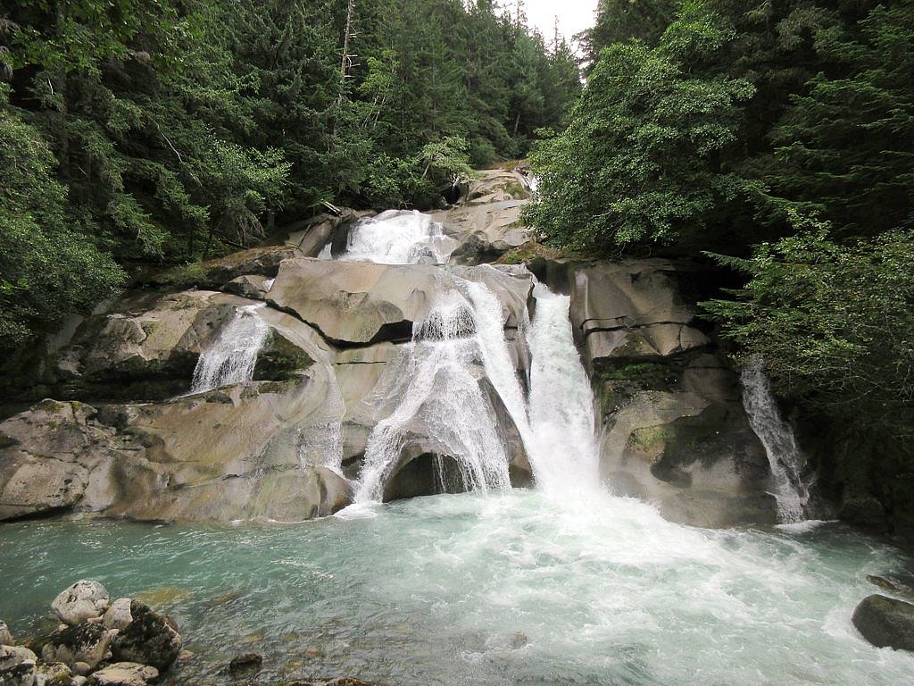
Photo Credits (4)
Difficulty
Easy
Trail Length
0.6 km
Trail Type
Out And Back
Elevation Gain
4 m
About Clayton Falls
Clayton Falls (approximate coordinates 52.3695, -126.8135) is a forested inland British Columbia waterfall on a smaller tributary. Details about official name usage, exact drop measurements, and developed facilities are limited in public trail resources. The waterfall appears to be in a remote, wooded setting and may have highly seasonal flow, highest in spring from snowmelt and lower in late summer and fall. Visitors should treat descriptions as approximate and verify current conditions before traveling.
Why This Waterfall Exists
Clayton Falls flows over hard intrusive rock laid down about 101-145 million years ago. These resistant rocks form a durable ledge that water cannot easily wear away, creating the falls where softer material downstream has already eroded.
Trail & Hike Details
The Approach
The easy 0.6-km out-and-back trail gains 4 metres of elevation on the way to the falls.
Trail Description
There is limited verified information about a maintained trail to Clayton Falls. Visitors should expect either an unmarked path or cross-country travel through forest and possibly brush to reach viewpoints. Terrain may be uneven, steep in places, and may require route-finding skills. If a short spur trail exists from a roadside pullout, it may be informal and not signed or maintained. Treat this as a backcountry approach unless you confirm a developed trail from a reliable source.
What to Expect
A small-to-medium waterfall in a forested, inland British Columbia setting. Expect dense vegetation, mossy rock, and possibly slippery banks. Flow may vary widely with season, spring melt increases volume; late summer can be low. Limited or no facilities (no restrooms, signage, or guardrails). Remote area with possibly limited cell reception and nearby industrial activity (logging) in some regions.
Accessibility
The trail is short and relatively flat, but the surface may be uneven. Contact the managing agency for accessibility details.
Frequently Asked Questions
🐶 Are Dogs Allowed at Clayton Falls?
❌ Dogs are not allowed
Are There Any Fees or Permits Required?
🆖 No fees required
🏊 Is There Swimming at Clayton Falls?
❌ Swimming is not allowed
When to Visit
Late spring to early summer for peak flow (snowmelt) and generally good daylight. Mid- to late summer may offer easier road access but lower flows. Fall provides color but check for early snowfall and road closures. Visit during daylight and calmer weather for safer footing and better photos.
Seasonal Access
The best time to visit is Spring, Summer, and Fall. Winter access may be limited. Check with the managing park or local authority for current conditions.
Safety Information
Hazards may include: steep or unstable banks and cliffs, slippery wet rocks, fast cold water and strong currents during high flow, falling rocks, limited cell coverage, and changing weather. Logging roads can have active industrial traffic; obey signage and use caution. Carry navigation aids, tell someone your plan, and consider turning back if conditions are uncertain. When in bear country, carry bear spray and know how to use it.
Current Water Conditions
16.4 m³/s
Current discharge — how much water is flowing
Higher than usual for this time of year
Based on 60 years of record
0.40 m
Water depth at gauge
7-Day Discharge Trend
What does this mean for your visit?
The water is flowing higher than usual for this time of year.
About This Gauge
This gauge is on a nearby waterway and may not reflect exact conditions at the falls.
7-Day Flow Outlook
Based on the WSC gauge SALLOOMT RIVER NEAR HAGENSBORG (21 km away).
Today
Strong
18 m³/s
8/10Tomorrow
Strong
17 m³/s
10/10Tue
Strong
16 m³/s
9/10Wed
Strong
16 m³/s
9/10Thu
Strong
16 m³/s
9/10Fri
Strong
16 m³/s
9/10Sat
Strong
17 m³/s
8/10Best window: Tomorrow — strong flow, mainly sunny (trip score 10/10).
Best time of year: this gauge typically runs highest from early May to late July, peaking in June.
How we calculate this
This is a transparent outlook, not a precise forecast. We take the waterfall's current flow strength (how it ranks against its historical normal for today, from the nearest WSC stream gauge), carry that ranking forward along the gauge's seasonal curve, and nudge it for forecast rain. Confidence is highest for the next day or two and falls further out. Always check official conditions and your own judgment before visiting — high flows can be dangerous.
Weather Forecast
Location & Access
Getting There
The falls are located in a remote region of British Columbia near the provided coordinates. Access may require driving on secondary or logging/gravel roads; some roads may be gated or seasonally closed. Low-clearance vehicles may have difficulty; a high-clearance or 4x4 vehicle may be advisable. Confirm route and road status with local district offices or recent trip reports before heading out.
Get Directions on Google MapsParking
No confirmed formal parking lot. Expect informal pullouts or roadside parking on a wide shoulder if available. Park safely off the travel lane and avoid blocking gates or logging operations. Parking availability may be limited.
Elevation
18 metres above sea level
Coordinates
52.369506° N, -126.813473° W
Visitor Tips & Gear
1) Check recent trip reports or local resources (forest district office, visitor centres) for up-to-date road and trail conditions before visiting. 2) Travel with a vehicle suitable for gravel/logging roads and obey all closure signs. 3) Wear sturdy waterproof footwear; expect wet, slippery rocks. 4) Carry a map, compass or GPS, routes may be unmarked. 5) Practice Leave No Trace; pack out all trash. 6) Be prepared for wildlife encounters and bring bear spray where appropriate. 7) Avoid edges and wet rocks; cliffs and undercut banks can be unstable.
As an Amazon Associate, we earn from qualifying purchases.
For this easy 0.6 km trail, lightweight trail shoes and a water bottle are usually sufficient. Sun exposure on the trail makes good sun protection a must in summer.

Polarized Sunglasses (Knockaround)
Cuts glare off the water so you actually see the falls — and your photos turn out better too.

Columbia Watertight II Rain Jacket
Packs into its own pocket, seam-sealed, and keeps you dry from spray and surprise rain.

Earth Pak Waterproof Dry Bag
Keeps your phone and gear dry when waterfall mist soaks everything else.

Waterproof Phone Pouch (AiRunTech)
Cheap insurance — take photos right next to the falls without killing your phone.

JOBY GorillaPod Starter Kit
Wraps around railings and rocks for long-exposure waterfall shots — no flat surface needed.

Osprey Daylite Daypack
Light, organized, and just the right size for a day hike — fits water, snacks, and layers.
Where to Stay
Browse vacation cabins and private rentals nearby
Unique outdoor stays — tents, yurts, and treehouses
Rent a campervan or RV for your waterfall road trip
Some links are affiliate links. We may earn a commission at no extra cost to you.
Nearby Campground
Bailey Bridge Cabins & Campsites
21.6 km away
Additional Information
Nearby Attractions
Specific nearby attractions are not confirmed. The area is typical of inland BC landscape, forested rivers, provincial parks, and backcountry recreation may be found in the broader region. Check local tourism resources for nearby provincial parks or known attractions.
Wildlife
Typical wildlife for inland British Columbia: black bear, grizzly bear (region-dependent), moose, deer, cougars, wolves, various small mammals and bird species. Ticks and biting insects can be seasonal nuisances. Be bear-aware and follow proper food/storage procedures.
Writing about Clayton Falls? Embed this waterfall on your site for free.