
Photo Credits (1)
Difficulty
Moderate
Trail Length
6.0 km
Trail Type
Out And Back
Elevation Gain
213 m
About Chutes Waber
Chutes Waber (sometimes listed as Chute Waber) is a waterfall feature in the Mauricie region of Quebec, located near the Shawinigan-Sud / Trois-Rivières corridor. The falls are set in a mixed forest and may be reached from local forest roads or short trails. Water flow is typically highest in spring snowmelt and after heavy rains; in winter the falls or surrounding cascades may be partially or fully iced. Detailed, authoritative trail info is limited or inconsistently documented, so some access details may vary and local signage or landowner rules could apply.
The Setting
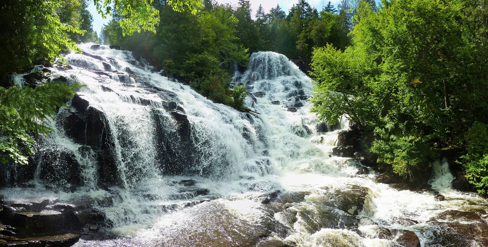
Chutes Waber sits at 328 metres within La Mauricie National Park, in the foothills of Quebec. The falls drop 27 metres.
Why This Waterfall Exists
Chutes Waber flows over hard crystalline rock, primarily gneiss, laid down over 1.0-2.5 billion years ago. These resistant rocks form a durable ledge that water cannot easily wear away, creating a 89-foot drop where softer material downstream has already eroded.
Trail & Hike Details
The Approach
The moderate 6.0-km out-and-back trail gains 213 metres of elevation on the way to the falls.
Trail Description
Publicly available, detailed trail descriptions are sparse. Access is generally via a short walk from a nearby road or informal trail; terrain is likely natural (dirt, roots, rocks) and may be uneven and slippery when wet or icy. There may be viewpoints or informal access to the riverbank above or below the falls. Because official trail maintenance information is limited, expect primitive conditions and use caution on steep or muddy sections.
What to Expect
The falls cascade 27 metres over hard crystalline rock.
Accessibility
The trail is not wheelchair accessible. Uneven terrain and elevation changes require steady footing.
Frequently Asked Questions
🐶 Are Dogs Allowed at Chutes Waber?
❌ Dogs are not allowed
Are There Any Fees or Permits Required?
🆖 No fees required
🏊 Is There Swimming at Chutes Waber?
❌ Swimming is not allowed
When to Visit
Late spring (during and just after snowmelt) for the fullest flows; late spring to early fall for easier access and milder weather; fall for foliage color. Winter can offer dramatic iced falls but requires winter gear and experience with icy/ snowy terrain. Check recent local conditions and road access before traveling.
Seasonal Access
The best time to visit is Spring, Summer, Fall, and Winter. Check with La Mauricie National Park for current conditions.
Safety Information
Hazards may include slippery rocks and riverbanks, strong currents near the falls, cold water temperatures, loose or steep trail sections, limited cell coverage, and seasonal ice. Use caution near edges, supervise children, and avoid approaching the edge of the falls during high flow. If visiting in winter, be prepared for avalanche-free but icy conditions and short daylight hours. Check local conditions and weather before visiting.
7-Day Flow Outlook
Based on the WSC gauge LOUP (RIVIERE DU) A 0,3 KM EN AVAL DU RUISSEAU CARUFEL (19 km away).
Best time of year: this gauge typically runs highest from early April to late June, peaking in April.
How we calculate this
This is a transparent outlook, not a precise forecast. We take the waterfall's current flow strength (how it ranks against its historical normal for today, from the nearest WSC stream gauge), carry that ranking forward along the gauge's seasonal curve, and nudge it for forecast rain. Confidence is highest for the next day or two and falls further out. Always check official conditions and your own judgment before visiting — high flows can be dangerous.
Know when to go.
Get a free email alert when waterfalls near Shawinigan-Sud hit peak flow. We only send when conditions are worth the trip — no weekly newsletters, no spam.
Weather Forecast
Location & Access
Getting There
Coordinates: 46.7658, -73.136. The falls are in the Mauricie / Shawinigan-Sud region of Quebec, approximately 27.9 miles from Shawinigan-Sud and 45.1 miles from Trois-Rivières (distances provided). Expect final access via local secondary roads and possibly short unpaved roads. Use a reliable map or GPS with the provided coordinates; cell coverage may be limited in some forested sections. Confirm access with local tourism offices in Shawinigan or the municipality before visiting.
Get Directions on Google MapsParking
Parking information is not consistently documented. There may be limited roadside or informal parking near the trailhead or access road; in some seasons parking could be on a narrow shoulder. Visitors should not block gates or private driveways and should follow any posted signs. Consider parking in a marked lot in the nearest town and confirming final approach locally if unsure.
Elevation
328 metres above sea level
Coordinates
46.765836° N, -73.135976° W
Land Management
Managed by Parks Canada Agency
Visitor Tips & Gear
• Confirm access and any restrictions with local municipal or tourism offices prior to visiting. • Wear sturdy shoes with good traction; approach banks and wet rocks cautiously. • Bring water, layers, and insect repellent in warm months; traction devices are recommended for winter. • Do not enter fast-moving water; currents near falls can be stronger than they appear. • Pack out all trash; respect private property and posted signage. • If parking is informal, do not block roads, gates, or driveways.
As an Amazon Associate, we earn from qualifying purchases.
With 6.0 km and 213 m of elevation gain, sturdy boots and trekking poles will help on this moderate trail. Icy conditions are common in winter — traction cleats are a smart addition.

Columbia Watertight II Rain Jacket
Packs into its own pocket, seam-sealed, and keeps you dry from spray and surprise rain.

Polarized Sunglasses (Knockaround)
Cuts glare off the water so you actually see the falls — and your photos turn out better too.

Earth Pak Waterproof Dry Bag
Keeps your phone and gear dry when waterfall mist soaks everything else.

Waterproof Phone Pouch (AiRunTech)
Cheap insurance — take photos right next to the falls without killing your phone.

Timberland Euro Sprint Mid Waterproof
Trusted waterproof boot with premium leather and grippy rubber sole — reliable on rocky, wet trails.

TrailBuddy Trekking Poles
Lightweight aluminum, cork grips, and flip-locks that actually hold — a best-seller for good reason.
Where to Stay
Browse vacation cabins and private rentals nearby
Unique outdoor stays — tents, yurts, and treehouses
Rent a campervan or RV for your waterfall road trip
Some links are affiliate links. We may earn a commission at no extra cost to you.
Nearby Campground
Lac Waber - 1
0.5 km away
Additional Information
Nearby Attractions
Shawinigan and the Mauricie region offer attractions such as Parc national de la Mauricie, Shawinigan hydroelectric sites, and riverfront areas in Trois-Rivières. Confirm driving times and plan visits around local services.
Wildlife
Typical wildlife for Mauricie-area forests: white-tailed deer, beaver, a variety of birds, black bear (less common), and numerous insects (including black flies and mosquitoes in spring/summer). Be aware of ticks in warmer months and take standard precautions.
Cities near Chutes Waber
Writing about Chutes Waber? Embed this waterfall on your site for free.