Photo Credits (4)
Difficulty
Easy
Trail Length
0.7 km
Trail Type
Out And Back
Elevation Gain
22 m
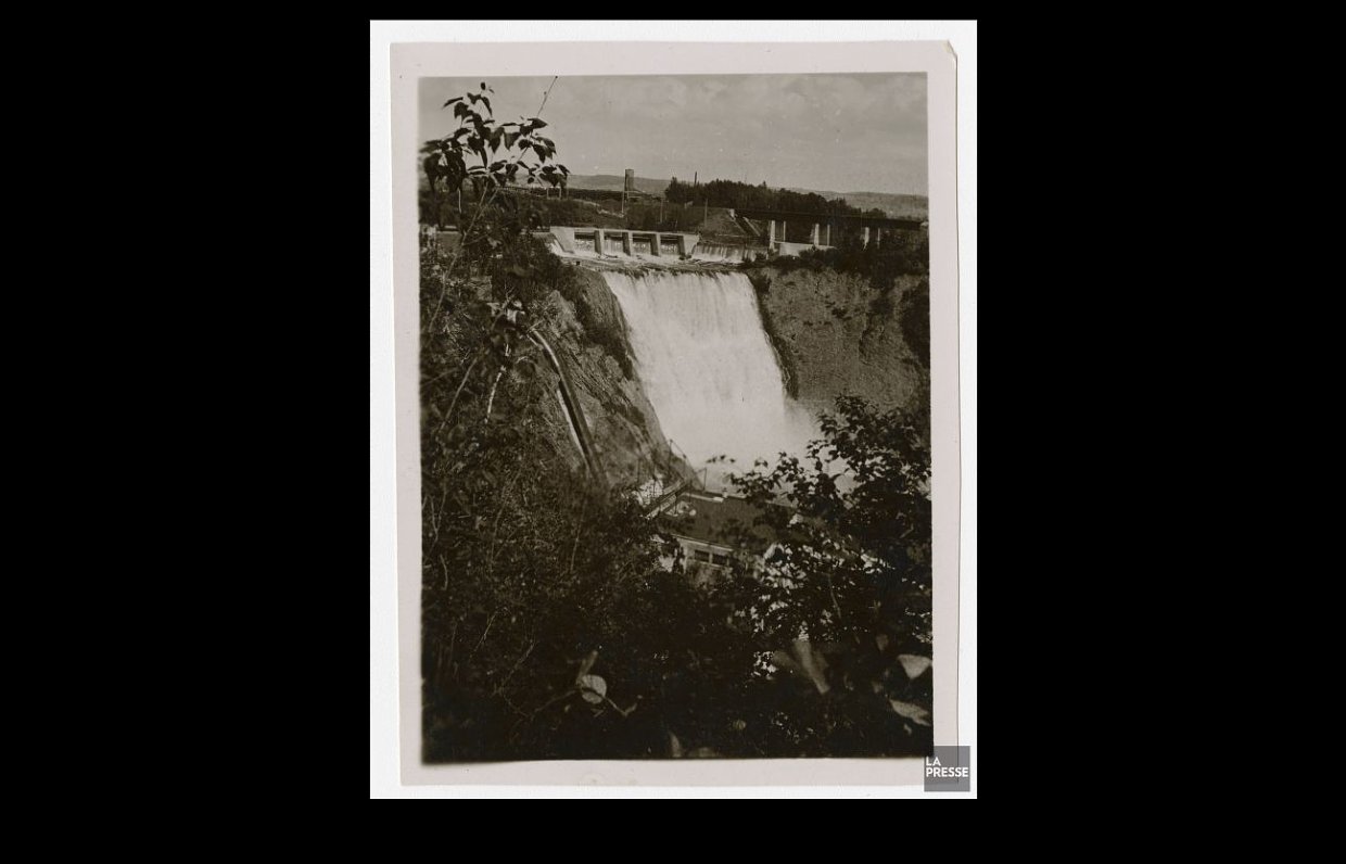
About Chutes
Chutes is a forested cascade site in the Laurentides region of Quebec near the provided coordinates (46.2096, -74.6006). The falls are in a rural, largely undeveloped setting and typically have their highest flow in spring (snowmelt). The site is best described as a scenic, natural waterfall in a mixed forest and rocky terrain; details such as official name, exact drop, and infrastructure vary by map and local references and may not be well signed on-site.
Why This Waterfall Exists
Chutes flows over hard intrusive rock laid down over 1.0-1.2 billion years ago. These resistant rocks form a durable ledge that water cannot easily wear away, creating the falls where softer material downstream has already eroded.
Trail & Hike Details
The Approach
The easy 0.7-km out-and-back trail gains 22 metres of elevation on the way to the falls.
Trail Description
Trail access, where present, is likely a short, natural footpath through mixed forest, with sections over roots and rocks. Trails may be muddy in wet seasons and slippery near the water. Boardwalks, railings, or formal stairs are not guaranteed. Some approaches may be very short (a few hundred meters) while others could require a longer walk along forest roads depending on the parking spot, local signage or recent visitor reports are the best source for exact route details.
What to Expect
Expect a wooded setting with rocky banks and potentially one or more cascades or drops. Water flow is highest in spring; summer flows can be reduced but still scenic. There are likely no on-site services (toilets, drinking water, or lifeguards). Cell reception may be intermittent. Terrain near the water may be uneven and wet; pools and plunge areas, if present, can have cold, fast-moving water.
Accessibility
The trail is short and relatively flat, but the surface may be uneven. Contact the managing agency for accessibility details.
Frequently Asked Questions
🐶 Are Dogs Allowed at Chutes?
❌ Dogs are not allowed
Are There Any Fees or Permits Required?
🆖 No fees required
🏊 Is There Swimming at Chutes?
❌ Swimming is not allowed
When to Visit
Late spring (during or shortly after snowmelt) for the fullest flows and dramatic water levels. Early fall provides attractive foliage color. Summer is good for accessibility and warmer weather but flows may be lower. Winter offers ice and a different aesthetic but access can be difficult and hazardous.
Seasonal Access
The best time to visit is Spring, Summer, and Fall. Winter access may be limited. Check with the managing park or local authority for current conditions.
Safety Information
Hazards include slippery rocks, steep or unstable banks, cold and fast-moving water, variable cell reception, ticks and biting insects, and seasonal ice. There may be no emergency services immediately nearby. Check weather and recent trail reports before visiting, wear appropriate footwear, supervise children closely, and avoid getting too close to cliff edges or the lip of the falls.
7-Day Flow Outlook
Based on the WSC gauge DU DIABLE (RIVIERE) A 0.1KM EN AMONT DE LA ROUTE 117 (11 km away).
Best time of year: this gauge typically runs highest from early April to early June, peaking in April.
How we calculate this
This is a transparent outlook, not a precise forecast. We take the waterfall's current flow strength (how it ranks against its historical normal for today, from the nearest WSC stream gauge), carry that ranking forward along the gauge's seasonal curve, and nudge it for forecast rain. Confidence is highest for the next day or two and falls further out. Always check official conditions and your own judgment before visiting — high flows can be dangerous.
Know when to go.
Get a free email alert when waterfalls near Saint-Jérôme hit peak flow. We only send when conditions are worth the trip — no weekly newsletters, no spam.
Weather Forecast
Location & Access
Getting There
Use the provided coordinates (46.2096, -74.6006) in a GPS unit or mapping app. The site lies in the Laurentides region; larger nearby towns are Saint-Jérôme (~47 miles), Mont‑Laurier (~55 miles) and Montréal (~78 miles). Expect to travel on provincial and local roads; the final approach may be on gravel or forestry roads. Follow local signage if present and respect private property, parking and trailheads may be informal or unmarked.
Get Directions on Google MapsParking
Parking is likely informal (small pullout or roadside). There may be no developed parking lot, restrooms, or visitor facilities. Park off the road where it is safe and legal; bring a parking flashlight if arriving late in low light.
Elevation
230 metres above sea level
Coordinates
46.209642° N, -74.600592° W
Visitor Tips & Gear
• Check recent local trip reports or mapping apps before visiting; informal parking and access can change. • Wear sturdy, waterproof footwear with good traction. • Stay off slippery rocks near the water; keep a safe distance from the edge. • Pack out all trash and follow Leave No Trace principles. • If visiting in spring, expect higher flows and possible flooded approaches; in winter, trails may be icy and require snow/ice gear. • Respect private property and posted signs; do not trespass onto adjacent private land.
As an Amazon Associate, we earn from qualifying purchases.
For this easy 0.7 km trail, lightweight trail shoes and a water bottle are usually sufficient. Sun exposure on the trail makes good sun protection a must in summer.

Polarized Sunglasses (Knockaround)
Cuts glare off the water so you actually see the falls — and your photos turn out better too.

Columbia Watertight II Rain Jacket
Packs into its own pocket, seam-sealed, and keeps you dry from spray and surprise rain.

Earth Pak Waterproof Dry Bag
Keeps your phone and gear dry when waterfall mist soaks everything else.

Waterproof Phone Pouch (AiRunTech)
Cheap insurance — take photos right next to the falls without killing your phone.

JOBY GorillaPod Starter Kit
Wraps around railings and rocks for long-exposure waterfall shots — no flat surface needed.

Osprey Daylite Daypack
Light, organized, and just the right size for a day hike — fits water, snacks, and layers.
Where to Stay
Browse vacation cabins and private rentals nearby
Unique outdoor stays — tents, yurts, and treehouses
Rent a campervan or RV for your waterfall road trip
Some links are affiliate links. We may earn a commission at no extra cost to you.
Nearby Campground
Camp Kinneret Biluim
3.8 km away
Additional Information
Nearby Attractions
The falls sit in the broader Laurentides region which offers lakes, forested hiking areas, and small town services in places like Saint-Jérôme and Mont‑Laurier. Specific nearby parks or marked attractions should be checked on regional tourism sites or maps.
Wildlife
Typical Laurentides wildlife may be present: white-tailed deer, beaver, various bird species, small mammals, and potentially black bears. Observe wildlife from a distance and store food securely.
Cities near Chutes
Nearby Waterfalls
Other waterfalls named Chutes
1 other waterfall shares this name across Canada.
Writing about Chutes? Embed this waterfall on your site for free.