Photo Credits (1)
About Chutes Helen
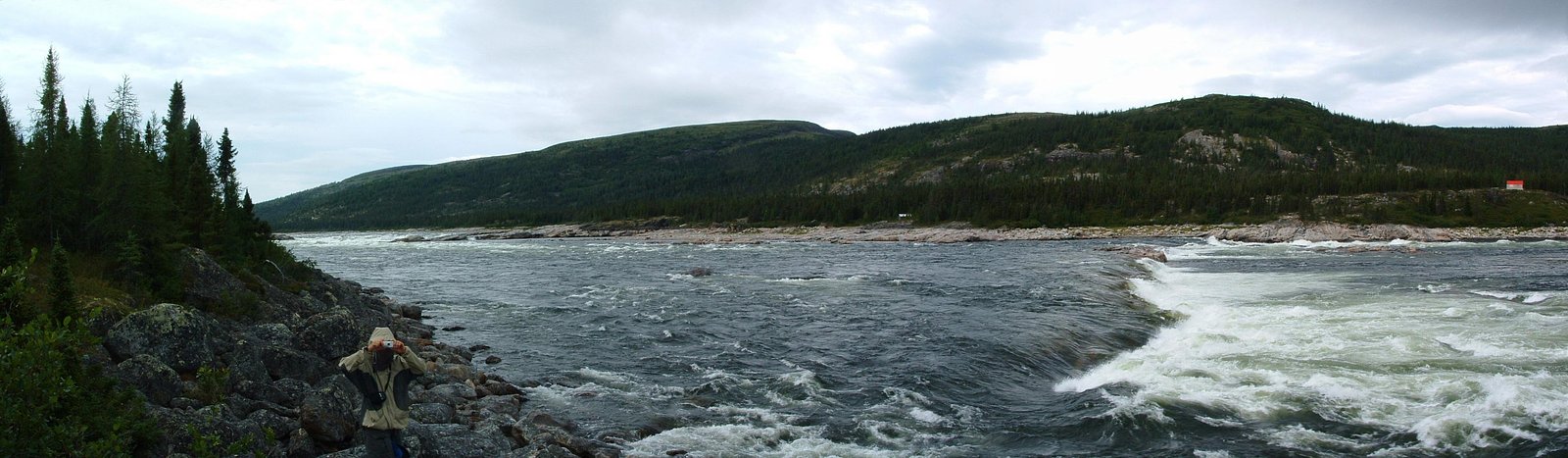
Chutes Helen is a waterfall identified by the provided coordinates in northern Quebec (Nunavik). This feature lies in a remote, sparsely documented area; there is little published trail or visitor infrastructure information available. The site appears to be in a wilderness setting with limited or no formal access roads. Visitors should treat location and access details as uncertain and verify locally (community, provincial authorities, or outfitter) before travel.
The Setting
Chutes Helen sits at 21 metres within Rivière-George Territorial reserve for protected area purposes, in the coastal lowlands of Quebec.
Why This Waterfall Exists
Chutes Helen flows over hard crystalline rock laid down over 2.5-3.2 billion years ago. These resistant rocks form a durable ledge that water cannot easily wear away, creating the falls where softer material downstream has already eroded.
Trail & Hike Details
Trail Description
There is no confirmed, published trail description for Chutes Helen. Expect no formal maintained trail, signage, or boardwalk. Reaching the waterfall may require route-finding across rugged tundra/boreal terrain, river crossings, and possible bushwhacking. If a short local access path exists, it is not widely documented; approach should be planned for a backcountry environment.
What to Expect
Remote wilderness setting with limited or no services, likely poor or no cellular coverage, and little to no visitor infrastructure. Seasonal flow will vary, spring melt commonly produces higher flows, while late summer and early fall may have lower water levels. Expect wet, slippery rock surfaces near the falls, steep banks, and possibly deep plunge pools or fast currents. In summer, expect abundant insects (mosquitoes, black flies). Weather can change rapidly.
Accessibility
There is no documented accessible infrastructure for people with mobility impairments. Access is likely over uneven, sometimes steep terrain, and may require water or air transport; therefore it is not wheelchair accessible.
Frequently Asked Questions
🐶 Are Dogs Allowed at Chutes Helen?
❌ Dogs are not allowed
Are There Any Fees or Permits Required?
🆖 No fees required
🏊 Is There Swimming at Chutes Helen?
❌ Swimming is not allowed
When to Visit
Late spring and early summer often offer the highest flows and dramatic scenery from snowmelt. Summer (June–August) generally provides the most reliable access and milder weather, though insects can be heavy. Fall offers color but shorter daylight and cooler weather. Winter can produce impressive frozen falls but is hazardous and requires specialized skills and equipment; approach only with winter backcountry experience.
Seasonal Access
The best time to visit is Spring, Summer, Fall, and Winter. Check with the managing park or local authority for current conditions.
Safety Information
Hazards include remoteness (long response times for rescue), no services or cell coverage, unstable and slippery rock near the falls, fast currents and cold water, sudden weather changes, insect swarms in summer, and potentially hazardous river crossings. Hypothermia risk is significant even in summer if wet. If flying or boating in, confirm landing locations and permits; floatplane/boat operations have their own risks. Always carry emergency communication and be prepared for self-rescue.
Weather Forecast
Location & Access
Getting There
Chutes Helen is located in a remote part of northern Quebec. There are likely no direct paved roads; access may require floatplane, boat, helicopter, long overland travel by ATV or hiking, or travel from a regional community by charter. Nearest settlements and access points may be many tens to hundreds of kilometres away. Confirm travel options with local authorities or outfitters.
Get Directions on Google MapsParking
No developed parking or visitor facilities are documented. If approaching by boat or floatplane, staging/landing will depend on local conditions and permissions from nearest community or land managers.
Elevation
21 metres above sea level
Coordinates
58.163687° N, -65.827506° W
Land Management
Managed by Ministère de l'Environnement, de la Lutte contre les changements climatiques, de la Faune et des Parcs, Direction des aires protégées
Visitor Tips & Gear
1) Confirm exact location and access plans with local authorities or outfitters well before travel. 2) Arrange reliable transport (floatplane, boat, charter) if not prepared for a long overland approach. 3) Travel with experienced backcountry partners and leave trip plans with someone. 4) Carry navigation (GPS with coordinates), satellite communicator or PLB, first-aid kit, and extra food/warm clothing. 5) Expect no potable water or toilet facilities; practice Leave No Trace. 6) Respect Indigenous lands and any local access rules, obtain permission when required.
Where to Stay
Browse vacation cabins and private rentals nearby
Unique outdoor stays — tents, yurts, and treehouses
Rent a campervan or RV for your waterfall road trip
Some links are affiliate links. We may earn a commission at no extra cost to you.
Additional Information
Nearby Attractions
This area is part of northern Quebec / Nunavik and may include other remote rivers, lakes, and coastal landscapes. Nearest established communities and visitor services may be many kilometres away, confirm local geography and distances before travel.
Wildlife
Typical northern Quebec wildlife may include migratory birds, caribou, small mammals, and bears. Species presence varies by exact location and season. Take standard precautions for wildlife encounters and check with local authorities about specific species risks.
Writing about Chutes Helen? Embed this waterfall on your site for free.