Photo Credits (2)
Difficulty
Easy
Trail Length
1.8 km
Trail Type
Out And Back
Elevation Gain
49 m
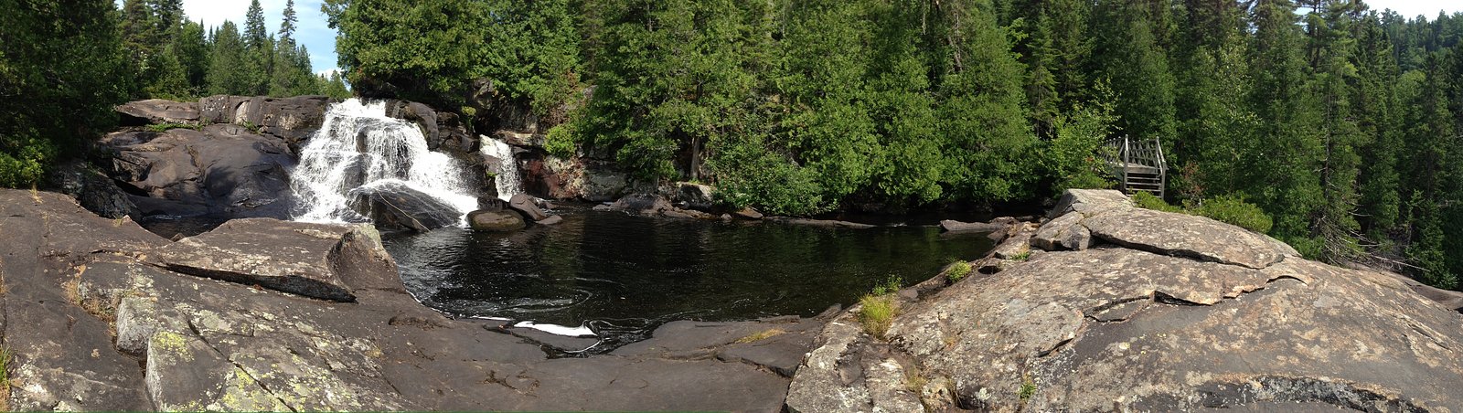
About Chutes Dunbar
Chutes Dunbar is a waterfall located in the Mauricie region of Quebec (coordinates 46.9478, -73.1102), near Shawinigan-Sud and within driving distance of Trois-Rivières. It appears to be a regionally known cascade accessed from local roads or short trails. Specifics about the exact drop and on-site facilities are not well-documented in widely available sources; the description below uses cautious language where details are uncertain.
Why This Waterfall Exists
Chutes Dunbar flows over hard crystalline rock, primarily gneiss, laid down over 1.0-2.5 billion years ago. These resistant rocks form a durable ledge that water cannot easily wear away, creating the falls where softer material downstream has already eroded.
Trail & Hike Details
The Approach
The easy 1.8-km out-and-back trail gains 49 metres of elevation on the way to the falls.
Trail Description
Trail details are not well-documented publicly. Access commonly consists of a short walk from a roadside parking area or a municipal path to one or more viewpoints. Trails may be natural surface, potentially uneven, with roots, rocks, and occasional stairs or boardwalk sections where developed. Signage may be limited.
What to Expect
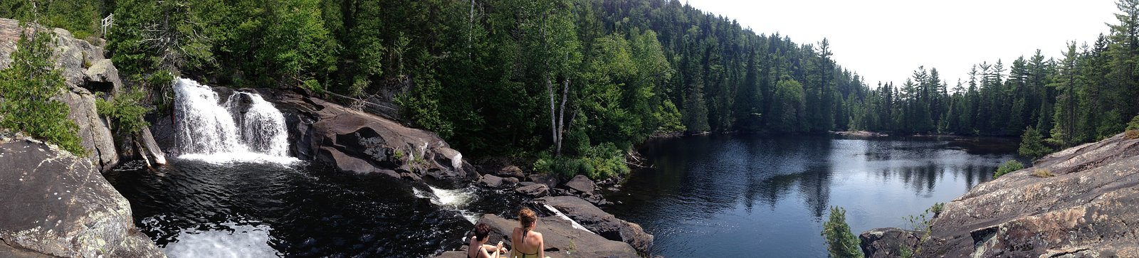
Expect a forested setting typical of the Mauricie area, with a flowing cascade that can be most impressive in spring or after heavy rain. There may be one or more viewpoints above or beside the falls; getting to the waterline may require scrambling over rocks and can be hazardous. Facilities (toilets, picnic tables, handrails) may be minimal or absent.
Accessibility
The trail is not wheelchair accessible. Uneven terrain and elevation changes require steady footing.
Frequently Asked Questions
🐶 Are Dogs Allowed at Chutes Dunbar?
❌ Dogs are not allowed
Are There Any Fees or Permits Required?
🆖 No fees required
🏊 Is There Swimming at Chutes Dunbar?
❌ Swimming is not allowed
When to Visit
Spring (high water) and fall (foliage) are often the most scenic. Summer offers warm weather but lower flows at times. Winter can offer frozen-scenery photo opportunities but increases hazards from ice and cold.
Seasonal Access
The best time to visit is Spring, Summer, Fall, and Winter. Check with the managing park or local authority for current conditions.
Safety Information
Hazards can include slippery wet rocks, steep drop-offs, fast-flowing water, unstable banks, and limited or no guardrails. In winter, ice and snow increase risk of falls and hypothermia. Cell service may be unreliable; do not rely solely on mobile phones for emergency calls. Carry basic first-aid supplies and tell someone your plans. Respect any posted warnings or closed areas.
7-Day Flow Outlook
Based on the WSC gauge LOUP (RIVIERE DU) A 0,3 KM EN AVAL DU RUISSEAU CARUFEL (39 km away).
Best time of year: this gauge typically runs highest from early April to late June, peaking in April.
How we calculate this
This is a transparent outlook, not a precise forecast. We take the waterfall's current flow strength (how it ranks against its historical normal for today, from the nearest WSC stream gauge), carry that ranking forward along the gauge's seasonal curve, and nudge it for forecast rain. Confidence is highest for the next day or two and falls further out. Always check official conditions and your own judgment before visiting — high flows can be dangerous.
Know when to go.
Get a free email alert when waterfalls near Shawinigan-Sud hit peak flow. We only send when conditions are worth the trip — no weekly newsletters, no spam.
Weather Forecast
Location & Access
Getting There
The falls are near Shawinigan-Sud (approximately 35–40 miles by road from the coordinates given) and reachable by local roads from the Mauricie region. Use the coordinates 46.9478, -73.1102 for GPS navigation. Expect rural roads; cellular reception may be spotty in places.
Get Directions on Google MapsParking
There may be a small roadside parking area or an informal/unpaved lot nearby. Parking could be limited and may not be signed. Visitors should be prepared to walk a short distance from where they park; verify local parking rules and respect private property.
Elevation
272 metres above sea level
Coordinates
46.947828° N, -73.110221° W
Visitor Tips & Gear
• Wear sturdy, waterproof footwear with good traction. • Stay back from cliff edges and fast-moving water; rocks are often slippery. • Check recent visitor reports or local tourism/municipal sites for access updates before you go. • Bring a map or download offline maps; cell signal may be unreliable. • Respect private property signs and posted rules. • If visiting in winter, be prepared for ice and deep snow; many trails become hazardous or impassable.
As an Amazon Associate, we earn from qualifying purchases.
This easy 1.8 km hike is straightforward — comfortable trail shoes and plenty of water should do. Icy conditions are common in winter — traction cleats are a smart addition.

Columbia Watertight II Rain Jacket
Packs into its own pocket, seam-sealed, and keeps you dry from spray and surprise rain.

Polarized Sunglasses (Knockaround)
Cuts glare off the water so you actually see the falls — and your photos turn out better too.

Earth Pak Waterproof Dry Bag
Keeps your phone and gear dry when waterfall mist soaks everything else.

Waterproof Phone Pouch (AiRunTech)
Cheap insurance — take photos right next to the falls without killing your phone.

Kahtoola MICROspikes
Cult-favorite traction cleats that grip ice and wet rock — essential for winter waterfall hikes.

JOBY GorillaPod Starter Kit
Wraps around railings and rocks for long-exposure waterfall shots — no flat surface needed.
Where to Stay
Browse vacation cabins and private rentals nearby
Unique outdoor stays — tents, yurts, and treehouses
Rent a campervan or RV for your waterfall road trip
Some links are affiliate links. We may earn a commission at no extra cost to you.
Nearby Campground
Lac-Dunbar
2.1 km away
Additional Information
Nearby Attractions
Shawinigan area attractions and regional parks in Mauricie may be within driving distance (e.g., municipal parks, riverside viewpoints, local hiking areas). Trois-Rivières and other regional destinations are reachable by car. For specific nearby points of interest, consult local tourism resources for the Mauricie or Shawinigan municipalities.
Wildlife
Typical regional wildlife may include white-tailed deer, small mammals (squirrels, raccoons), waterfowl, and beavers. Insects such as mosquitoes and black flies can be abundant in spring and summer. Always observe wildlife from a distance.
Cities near Chutes Dunbar
Writing about Chutes Dunbar? Embed this waterfall on your site for free.