Photo Credits (4)
Difficulty
Easy
Trail Length
1.3 km
Trail Type
Loop
Elevation Gain
23 m
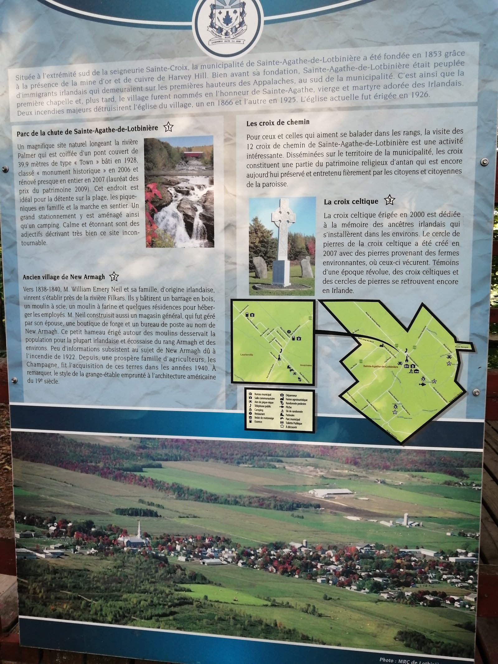
About Chutes de Sainte-Agathe
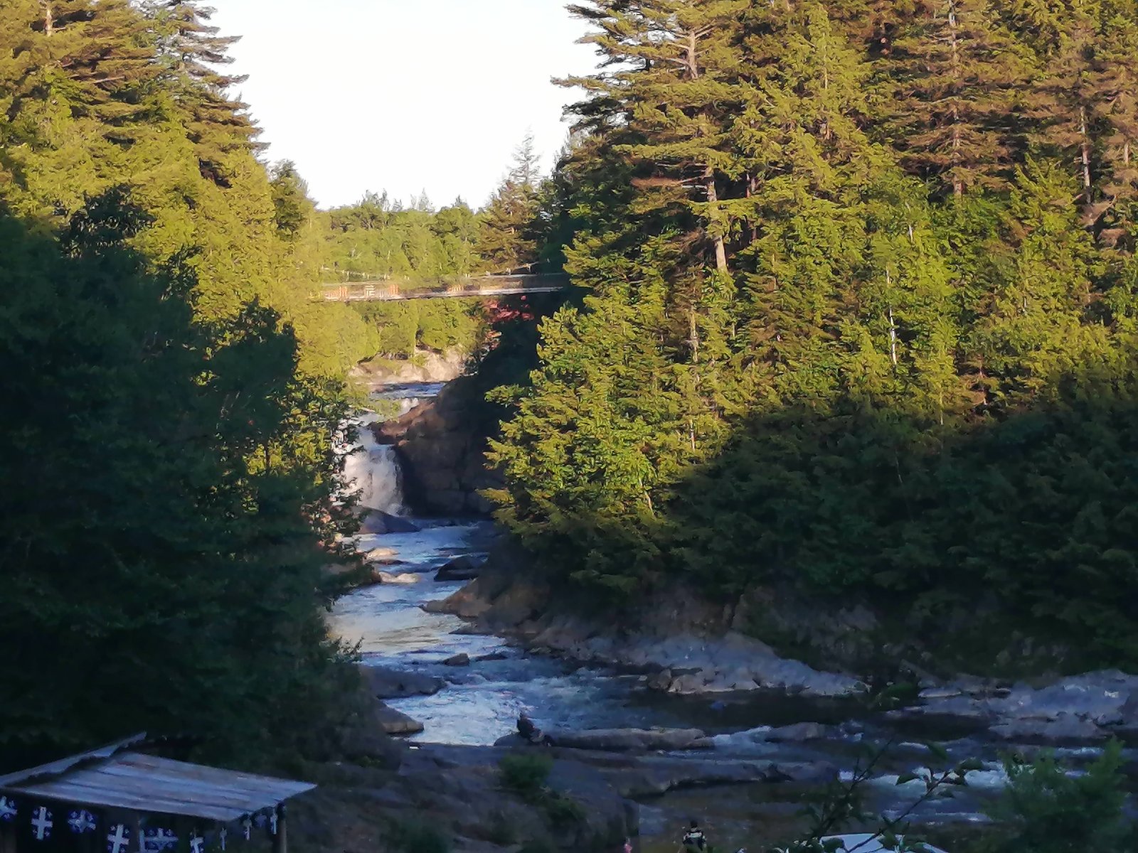
Chutes de Sainte-Agathe is a freshwater waterfall site in Québec province, located at coordinates 46.3316, -71.4166. The falls are in a mixed forest/rural setting and are best known for seasonal flow variations (high in spring melt, lower in late summer). Exact height and detailed infrastructure information are not confirmed; visitors should expect a natural, possibly undeveloped viewing area.
Why This Waterfall Exists
Chutes de Sainte-Agathe flows over layered sedimentary rock laid down about 252-539 million years ago. Over time, the stream has worn through these layers at different rates, creating the step that forms the waterfall.
Trail & Hike Details
The Approach
The easy 1.3-km loop trail gains 23 metres of elevation on the way to the falls.
Trail Description
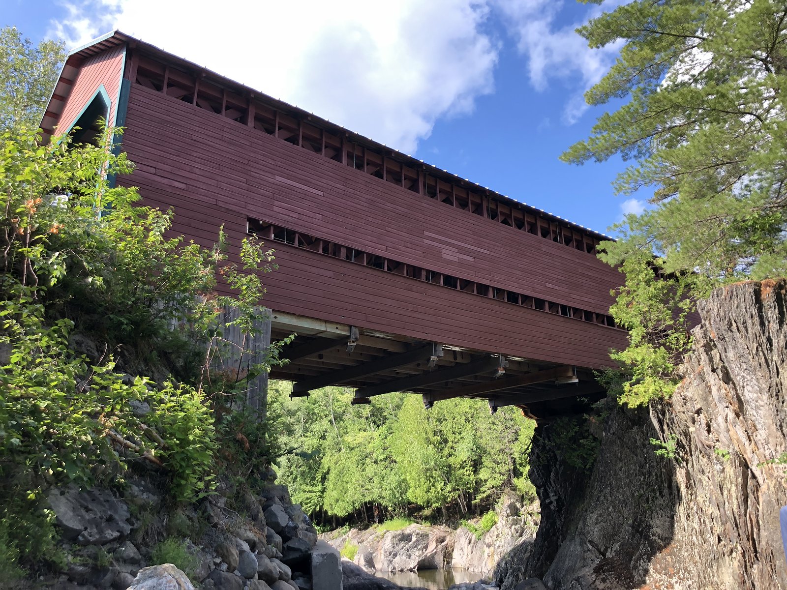
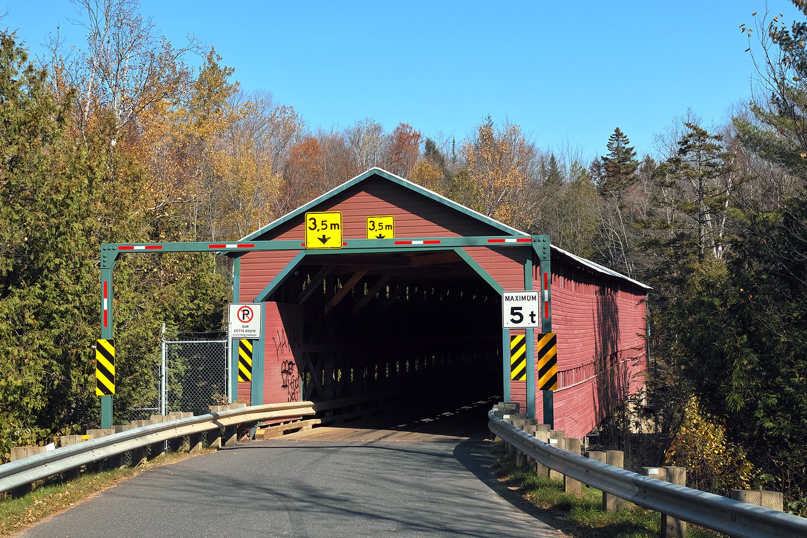
Trail and access details are not well-documented publicly. Visitors should expect a short walk from a roadside parking area to reach viewing locations, possibly along an unpaved or natural-surface path with roots, rocks and limited signage. Trails (if present) may include uneven terrain and short stair-like sections; exact distance and elevation gain are not confirmed.
What to Expect
A natural waterfall setting in a rural/forested landscape with seasonal flow changes. Spring runoff typically produces the highest flows and most dramatic appearance. Facilities are likely minimal (few or no railings, viewing platforms, or restrooms). Expect muddy or slippery conditions after rain or during spring melt. Views may be from a single vantage point rather than multiple developed overlooks.
Accessibility
The trail is short and relatively flat, but the surface may be uneven. Contact the managing agency for accessibility details.
Frequently Asked Questions
🐶 Are Dogs Allowed at Chutes de Sainte-Agathe?
❌ Dogs are not allowed
Are There Any Fees or Permits Required?
🆖 No fees required
🏊 Is There Swimming at Chutes de Sainte-Agathe?
❌ Swimming is not allowed
When to Visit
Late spring (high water) for dramatic flows; early fall for fall color and generally stable weather. Summer offers easier access but lower flows. Winter can show frozen falls but may be hazardous and access can be difficult, only attempt if prepared and experienced with winter travel.
Seasonal Access
The best time to visit is Spring, Summer, and Fall. Winter access may be limited. Check with the managing park or local authority for current conditions.
Safety Information
Hazards may include slippery rocks and trails, fast currents (especially during spring melt), steep or unguarded edges, and unstable or icy conditions in winter. Cell coverage can be limited in rural areas. Do not climb on wet rocks near the falls and supervise children closely. If conditions look hazardous (high water, ice, or storm damage), do not attempt to approach the water.
7-Day Flow Outlook
Based on the WSC gauge BECANCOUR (RIVIERE) A 2,1 KM EN AMONT DE LA RIVIERE PALMER (4 km away).
Best time of year: this gauge typically runs highest from late March to mid May, peaking in April.
How we calculate this
This is a transparent outlook, not a precise forecast. We take the waterfall's current flow strength (how it ranks against its historical normal for today, from the nearest WSC stream gauge), carry that ranking forward along the gauge's seasonal curve, and nudge it for forecast rain. Confidence is highest for the next day or two and falls further out. Always check official conditions and your own judgment before visiting — high flows can be dangerous.
Know when to go.
Get a free email alert when waterfalls near Québec hit peak flow. We only send when conditions are worth the trip — no weekly newsletters, no spam.
Weather Forecast
Location & Access
Getting There
Location coordinates: 46.3316, -71.4166. The site is reachable by car from Québec City (about 30 miles / 48 km), Victoriaville (about 36 miles / 58 km) and Saint-Georges (about 41.5 miles / 67 km). Access is typically via local/regional roads; use the provided coordinates in a GPS device or mapping app. Signage and formal turn-offs may be limited, follow local road signs and any posted private property notices.
Get Directions on Google MapsParking
Parking appears to be limited and may be a small roadside pullout or a modest parking area. Expect limited facilities (no guaranteed restrooms or visitor center). Park legally and avoid blocking driveways or farm access.
Elevation
205 metres above sea level
Coordinates
46.331572° N, -71.416615° W
Visitor Tips & Gear
1) Use the provided coordinates and a reliable mapping app to locate the site. 2) Wear sturdy, non-slip shoes, rocks and trails can be slick. 3) Bring insect repellent in spring/summer and extra layers in cooler seasons. 4) Leave no trace: pack out trash and respect private property. 5) Check local conditions before visiting (high water, closures, private land access). 6) If visiting in winter, be aware of thin ice and icy trails; traction devices may be needed.
As an Amazon Associate, we earn from qualifying purchases.
For this easy 1.3 km trail, lightweight trail shoes and a water bottle are usually sufficient. Sun exposure on the trail makes good sun protection a must in summer.

Polarized Sunglasses (Knockaround)
Cuts glare off the water so you actually see the falls — and your photos turn out better too.

Columbia Watertight II Rain Jacket
Packs into its own pocket, seam-sealed, and keeps you dry from spray and surprise rain.

Earth Pak Waterproof Dry Bag
Keeps your phone and gear dry when waterfall mist soaks everything else.

Waterproof Phone Pouch (AiRunTech)
Cheap insurance — take photos right next to the falls without killing your phone.

JOBY GorillaPod Starter Kit
Wraps around railings and rocks for long-exposure waterfall shots — no flat surface needed.

Osprey Daylite Daypack
Light, organized, and just the right size for a day hike — fits water, snacks, and layers.
Where to Stay
Browse vacation cabins and private rentals nearby
Unique outdoor stays — tents, yurts, and treehouses
Rent a campervan or RV for your waterfall road trip
Some links are affiliate links. We may earn a commission at no extra cost to you.
Nearby Campground
Camping du Parc de la Chute
0.4 km away
Additional Information
Nearby Attractions
Québec City (~29.9 miles / ~48 km), Victoriaville (~36.1 miles / ~58 km), Saint-Georges (~41.5 miles / ~67 km). Local rivers, small regional parks and scenic countryside are common in the area; specifics should be verified locally.
Wildlife
Typical temperate-forest wildlife may be present: songbirds, waterfowl, small mammals (squirrels, rabbits), white-tailed deer, and seasonal insects. Be mindful of ticks in warmer months.
Cities near Chutes de Sainte-Agathe
Nearby Waterfalls
Writing about Chutes de Sainte-Agathe? Embed this waterfall on your site for free.