Photo Credits (2)
Difficulty
Easy
Trail Length
8.7 km
Trail Type
Out And Back
Elevation Gain
28 m
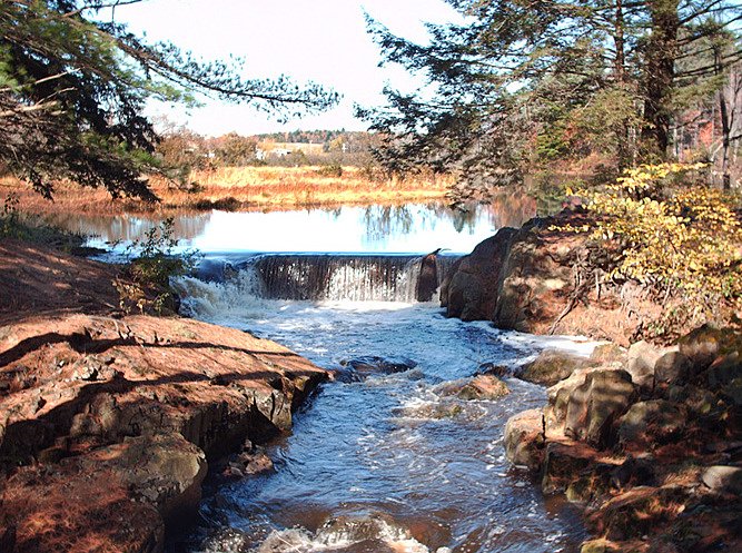
About Chutes à Kendall
Chutes à Kendall is a waterfall located in the Estrie (Eastern Townships) region of Quebec, roughly 12.1 miles from Sherbrooke (coordinates 45.5851, -71.9731). It is a local cascades feature in a mixed forest / river valley landscape typical of the area. Exact published height, formal name variations, and land ownership/public access details are not clearly documented in major trail databases; visitors should confirm access with local municipal or tourism resources before visiting. The waterfall is most notable as a scenic, natural cascade rather than a large, high-profile falls.
Why This Waterfall Exists
Chutes à Kendall flows over layered sedimentary rock laid down about 444-485 million years ago. Over time, the stream has worn through these layers at different rates, creating the step that forms the waterfall.
Trail & Hike Details
The Approach
The easy 8.7-km out-and-back trail gains 28 metres of elevation on the way to the falls.
Trail Description
There is no widely published, authoritative trail description for Chutes à Kendall in major trail databases. If a maintained trail exists it is likely a short, informal path from a roadside pullout or small lot down to a riverside viewing area. Expect uneven, possibly steep terrain close to the water. Trails in the region are frequently natural surface (dirt, roots, rocks) and can be muddy after rain or snowmelt.
What to Expect
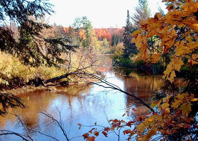
Expect a modest cascade in a forested river valley typical of the Eastern Townships: rock ledges, tree-lined banks, and seasonal flow variation (strongest in spring). There may be exposed rocks and steep banks near the water. Facilities (restrooms, signs, rails) may be limited or absent. Cell service may be intermittent in some rural sections.
Accessibility
The trail is not wheelchair accessible. Uneven terrain and elevation changes require steady footing.
Frequently Asked Questions
🐶 Are Dogs Allowed at Chutes à Kendall?
❌ Dogs are not allowed
Are There Any Fees or Permits Required?
🆖 No fees required
🏊 Is There Swimming at Chutes à Kendall?
❌ Swimming is not allowed
When to Visit
Spring (snowmelt) for highest flows and dramatic appearance; late spring through early fall for easier access, green scenery and warmer temperatures; fall for foliage color. Winter can create impressive ice formations but access may be difficult or dangerous (ice, snow, limited parking).
Seasonal Access
The best time to visit is Spring, Summer, Fall, and Winter. Check with the managing park or local authority for current conditions.
Safety Information
Hazards may include slippery rocks and trails, steep or unstable banks near the water, strong currents and undertows close to the falls, falling rock in some areas, ice in winter, and limited or no railings/guardrails. Cell service may be intermittent. Respect private property boundaries and posted signage. Bring a companion when possible and tell someone your plans. In winter, ice near falls is unpredictable and may be extremely dangerous, avoid walking on frozen water unless confirmed safe by authorities.
7-Day Flow Outlook
Based on the WSC gauge SAINT-FRANCOIS (RIVIERE) A SHERBROOKE (21 km away).
Best time of year: this gauge typically runs highest from early March to mid May, peaking in April.
How we calculate this
This is a transparent outlook, not a precise forecast. We take the waterfall's current flow strength (how it ranks against its historical normal for today, from the nearest WSC stream gauge), carry that ranking forward along the gauge's seasonal curve, and nudge it for forecast rain. Confidence is highest for the next day or two and falls further out. Always check official conditions and your own judgment before visiting — high flows can be dangerous.
Know when to go.
Get a free email alert when waterfalls near Sherbrooke hit peak flow. We only send when conditions are worth the trip — no weekly newsletters, no spam.
Weather Forecast
Location & Access
Getting There
Approximate location: 45.5851, -71.9731 in the Estrie (Eastern Townships) region. From downtown Sherbrooke drive roughly 12 miles (north/northwest depending on route). The site is also within driving distance of Victoriaville (~24 miles) and Derby Line (~34 miles). Access is typically by local paved or gravel roads; the final approach may be a short unmarked path or roadside viewpoint. Consult local maps, the nearest municipal office, or regional tourism for the most current access information.
Get Directions on Google MapsParking
Parking may be limited, expect a small pullout or roadside parking rather than a formal parking lot. If you find a municipal or park lot, use signed parking only. Do not block private driveways or gates. Confirm parking availability locally.
Elevation
185 metres above sea level
Coordinates
45.585118° N, -71.973140° W
Visitor Tips & Gear
1) Verify land ownership and access with the local municipality or tourism office before visiting. 2) Wear sturdy, grippy footwear, rocks and trails near waterfalls are often slippery. 3) Avoid getting too close to the edge; fall hazards and unstable banks are common. 4) Bring insect repellent in spring/summer and check for ticks after visits. 5) Pack out all trash and respect any posted signs or private property. 6) If conditions are icy or after heavy rain, consider postponing your visit.
As an Amazon Associate, we earn from qualifying purchases.
This easy 8.7 km hike is straightforward — comfortable trail shoes and plenty of water should do. Icy conditions are common in winter — traction cleats are a smart addition.

Columbia Watertight II Rain Jacket
Packs into its own pocket, seam-sealed, and keeps you dry from spray and surprise rain.

Polarized Sunglasses (Knockaround)
Cuts glare off the water so you actually see the falls — and your photos turn out better too.

Earth Pak Waterproof Dry Bag
Keeps your phone and gear dry when waterfall mist soaks everything else.

Waterproof Phone Pouch (AiRunTech)
Cheap insurance — take photos right next to the falls without killing your phone.

Kahtoola MICROspikes
Cult-favorite traction cleats that grip ice and wet rock — essential for winter waterfall hikes.

Sawyer Squeeze Water Filter
The backcountry standard — filters 99.9% of bacteria and weighs just 3 oz.
Where to Stay
Browse vacation cabins and private rentals nearby
Unique outdoor stays — tents, yurts, and treehouses
Rent a campervan or RV for your waterfall road trip
Some links are affiliate links. We may earn a commission at no extra cost to you.
Nearby Campground
Camping et Parc Watopeka
2 km away
Additional Information
Nearby Attractions
Nearby regional attractions in the Eastern Townships that visitors often combine with waterfall visits include Mont-Orford (Mont-Orford National Park), Lac Memphrémagog and surrounding lakes, and various small-town cultural and food attractions in Sherbrooke and surrounding municipalities. Exact proximity to any particular park entrance should be checked on a map for trip planning.
Wildlife
Typical Eastern Townships wildlife: white-tailed deer, small mammals, many bird species, black bear (less commonly), and abundant insects in warmer months. Ticks are present; take appropriate precautions.
Cities near Chutes à Kendall
Writing about Chutes à Kendall? Embed this waterfall on your site for free.