Photo Credits (3)
Difficulty
Easy
Trail Length
4.5 km
Trail Type
Loop
Elevation Gain
76 m
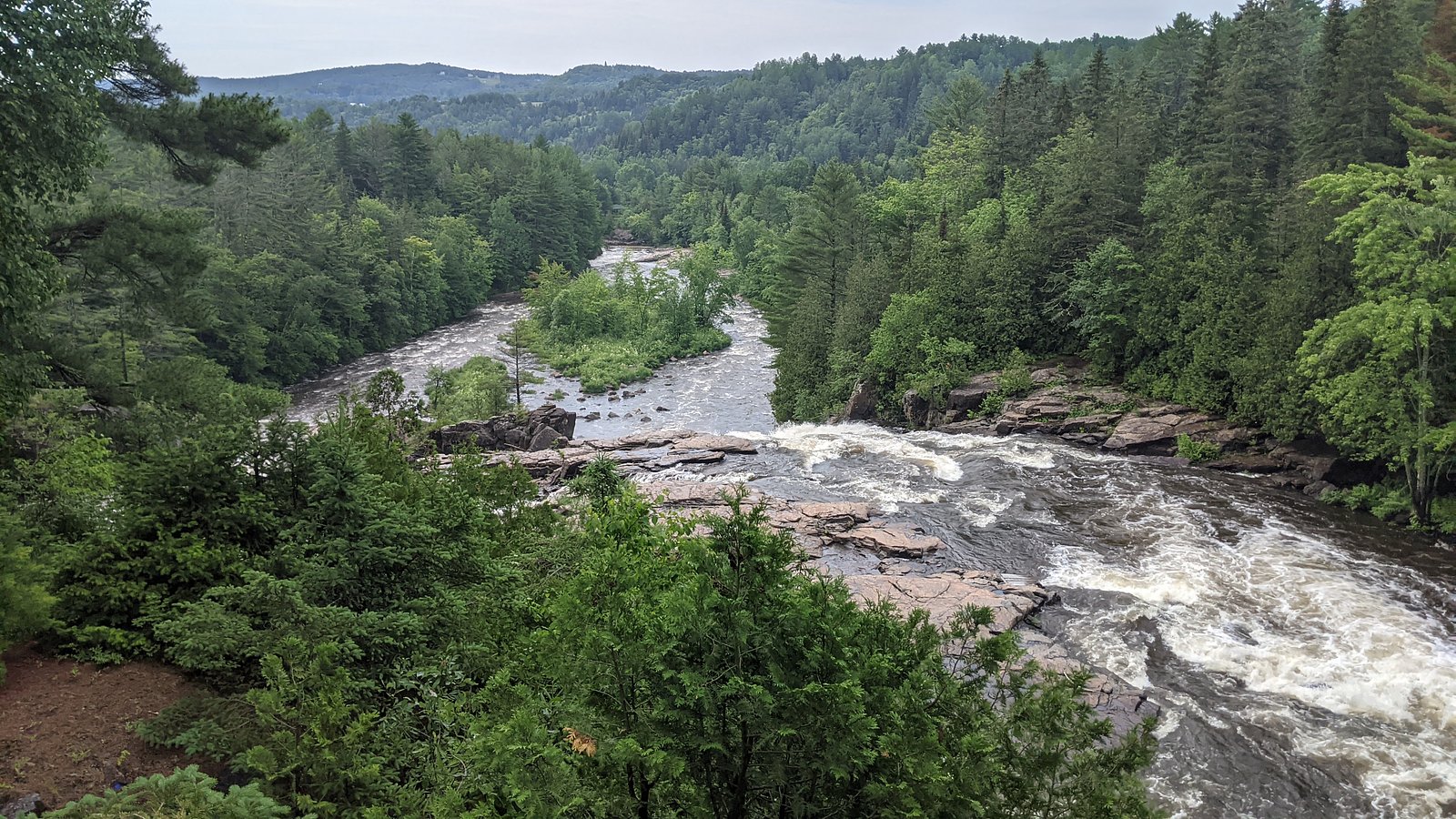
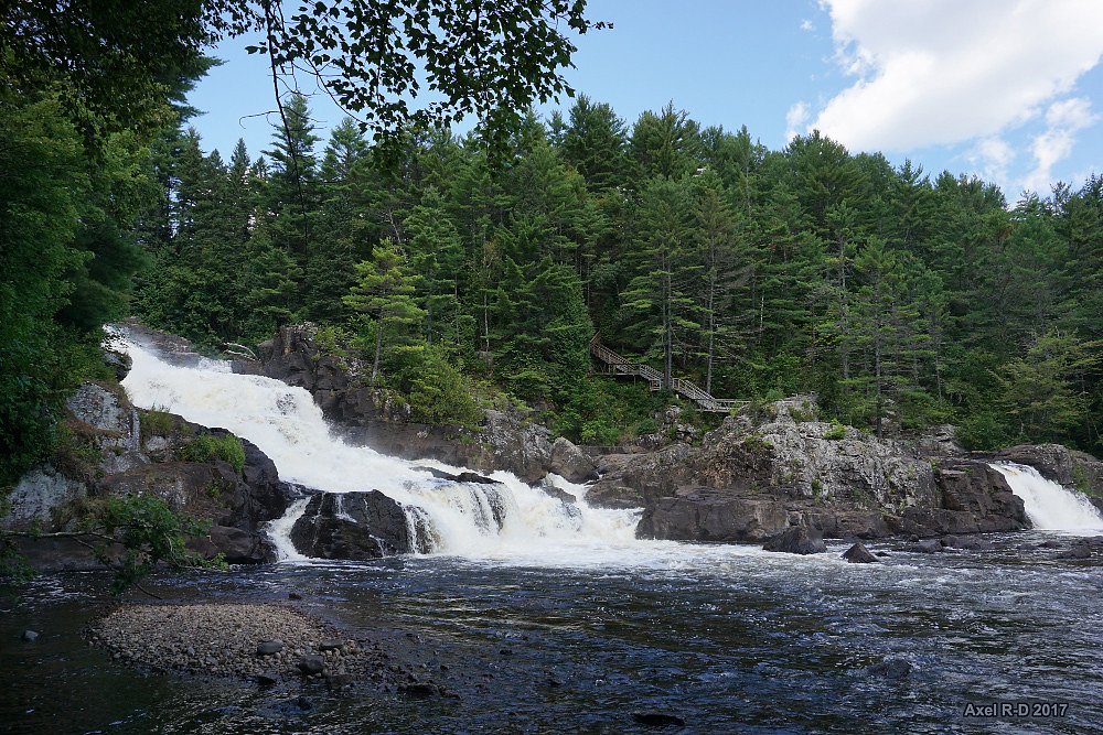
About Chute Monte-à-Peine
Chute Monte-à-Peine is a small to medium-sized waterfall located in the Lanaudière region of Quebec, near Joliette (approx. 13.2 miles), Montréal (approx. 35.4 miles) and Saint-Jérôme (approx. 40.0 miles). Coordinates: 46.2034, -73.5585. Information about this fall is limited in widely published trail guides; it appears to be a more local/less-developed site visited by people familiar with the area. Expect a natural, forested setting with rocky banks and a seasonal flow that is typically highest in spring during snowmelt and lower in dry summer months. Specific measured height and official management details are not confidently documented here.
Why This Waterfall Exists
Chute Monte-à-Peine flows over hard crystalline rock, primarily gneiss, laid down over 1.0-1.6 billion years ago. These resistant rocks form a durable ledge that water cannot easily wear away, creating the falls where softer material downstream has already eroded.
Trail & Hike Details
The Approach
The easy 4.5-km loop trail gains 76 metres of elevation on the way to the falls.
Trail Description
Detailed, authoritative trail data is not readily available for Chute Monte-à-Peine. From visitor reports for similarly undeveloped roadside/forest falls in the region, expect an unpaved footpath of variable maintenance leading downhill toward the stream. Trails may be narrow, rooted, rocky, and possibly steep or slippery near the water. There may be short scramble sections close to the falls for better views. Signage and handrails are unlikely. Treat the route as a backcountry/non-developed trail unless you find recent on-site reports indicating otherwise.
What to Expect
A natural, forested setting with rock ledges and a cascading water feature. Flow will vary seasonally, highest in spring (snowmelt) and after heavy rains, reduced in late summer. The pool at the base (if present) may be shallow and rocky. Expect limited facilities (no toilets, trash bins, or visitor center) and minimal or no formal viewpoints. Wildlife typical of southern Quebec woodlands (songbirds, squirrels, white-tailed deer, beaver activity in nearby waterways) may be present.
Accessibility
The trail is not wheelchair accessible. Uneven terrain and elevation changes require steady footing.
Frequently Asked Questions
🐶 Are Dogs Allowed at Chute Monte-à-Peine?
❌ Dogs are not allowed
Are There Any Fees or Permits Required?
🆖 No fees required
🏊 Is There Swimming at Chute Monte-à-Peine?
❌ Swimming is not allowed
When to Visit
Spring (late March–May) for strongest flows and dramatic water volume. Fall (September–October) for foliage color combined with moderate flows. Summer is pleasant but flow may be reduced. Winter can produce attractive ice formations but requires winter hiking experience, snow/ice traction, and awareness of seasonal access limitations.
Seasonal Access
The best time to visit is Spring, Summer, Fall, and Winter. Check with the managing park or local authority for current conditions.
Safety Information
Hazards may include slippery and unstable rocks near the water, steep or unmaintained paths, fast-flowing water in spring or after storms, hypothermia risk in cold water, ticks in warm months, and limited cell coverage. There may be no formal rescue access; visit with a companion when possible. Respect posted signage and private property boundaries. If visiting in winter, use appropriate traction devices and be cautious of ice over water which can be hazardous.
7-Day Flow Outlook
Based on the WSC gauge BAYONNE (RIVIERE) A ST-FELIX-DE-VALOIS (14 km away).
Best time of year: this gauge typically runs highest from late March to mid May, peaking in April.
How we calculate this
This is a transparent outlook, not a precise forecast. We take the waterfall's current flow strength (how it ranks against its historical normal for today, from the nearest WSC stream gauge), carry that ranking forward along the gauge's seasonal curve, and nudge it for forecast rain. Confidence is highest for the next day or two and falls further out. Always check official conditions and your own judgment before visiting — high flows can be dangerous.
Know when to go.
Get a free email alert when waterfalls near Joliette hit peak flow. We only send when conditions are worth the trip — no weekly newsletters, no spam.
Weather Forecast
Location & Access
Getting There
Use the provided coordinates (46.2034, -73.5585) in a GPS device or mapping app. The falls lie in the rural/forested area northeast of Montréal and near Joliette; access is likely via local municipal or forest service roads off the main regional highways. Roadside signage and well-marked trailheads may be limited. Visitors should plan to navigate small secondary roads and to follow local access signs or directions from municipalities or regional park authorities when available.
Get Directions on Google MapsParking
Parking may be limited to a small informal turnout or roadside space near an access point. There may not be an official paved parking lot. Expect uneven ground and limited capacity; park legally and avoid blocking roads. If unsure, check with the nearest municipality (Joliette area) before visiting.
Elevation
141 metres above sea level
Coordinates
46.203384° N, -73.558548° W
Visitor Tips & Gear
• Use the exact coordinates and plan your route before you go; cell service may be unreliable in rural areas. • Wear sturdy, traction-capable footwear; rocks near falls are often slippery. • Bring a map or GPS and let someone know your plans if the area is remote. • Respect private property and posted signs, some nearby falls in the region are on or adjacent to private land. • Carry out all trash and follow Leave No Trace. • In spring and after rain expect high, fast water; keep a safe distance from edges. • Check for ticks in warm months and be prepared for insects. • If unsure about access or safety, contact the nearest municipal office (Joliette) or regional park authority for up-to-date local guidance.
As an Amazon Associate, we earn from qualifying purchases.
This easy 4.5 km hike is straightforward — comfortable trail shoes and plenty of water should do. Icy conditions are common in winter — traction cleats are a smart addition.

Columbia Watertight II Rain Jacket
Packs into its own pocket, seam-sealed, and keeps you dry from spray and surprise rain.

Polarized Sunglasses (Knockaround)
Cuts glare off the water so you actually see the falls — and your photos turn out better too.

Earth Pak Waterproof Dry Bag
Keeps your phone and gear dry when waterfall mist soaks everything else.

Waterproof Phone Pouch (AiRunTech)
Cheap insurance — take photos right next to the falls without killing your phone.

Kahtoola MICROspikes
Cult-favorite traction cleats that grip ice and wet rock — essential for winter waterfall hikes.

JOBY GorillaPod Starter Kit
Wraps around railings and rocks for long-exposure waterfall shots — no flat surface needed.
Where to Stay
Browse vacation cabins and private rentals nearby
Unique outdoor stays — tents, yurts, and treehouses
Rent a campervan or RV for your waterfall road trip
Some links are affiliate links. We may earn a commission at no extra cost to you.
Nearby Campground
Camping Vacances St-Tropez
3.1 km away
Additional Information
Nearby Attractions
Nearest population centers: Joliette (~13.2 miles), Montréal (~35.4 miles), Saint-Jérôme (~40.0 miles). For organized recreation and amenities, consult parks and attractions in the Lanaudière region and the Joliette area (museums, local parks). Exact nearby named attractions specific to the falls are not confidently documented here.
Wildlife
Typical southern Quebec forest and riparian species may be present: songbirds, woodpeckers, small mammals (squirrels, raccoons), white-tailed deer, and evidence of beaver activity along waterways. Black bears exist in parts of Quebec but sightings near this specific site are not documented here; exercise standard wildlife precautions.
Cities near Chute Monte-à-Peine
Writing about Chute Monte-à-Peine? Embed this waterfall on your site for free.