Chute Malbaie
Quebec • Hautes-Gorges-de-la-Rivière-Malbaie National Park • 10 m
By Armen Suny · Last verified Jun 2026
About Chute Malbaie
Chute Malbaie is a relatively remote waterfall in the Saguenay–Lac-Saint-Jean region of Quebec. The falls are located near the Malbaie drainage and are approximately 38.7 miles (about 62 km) from Chicoutimi. Flow and appearance vary seasonally: high flows are typical in spring snowmelt, summer offers lower but accessible flows, fall provides scenic foliage, and the waterfall may be heavily iced in winter. Exact height and official signage appear to be limited or not widely documented.
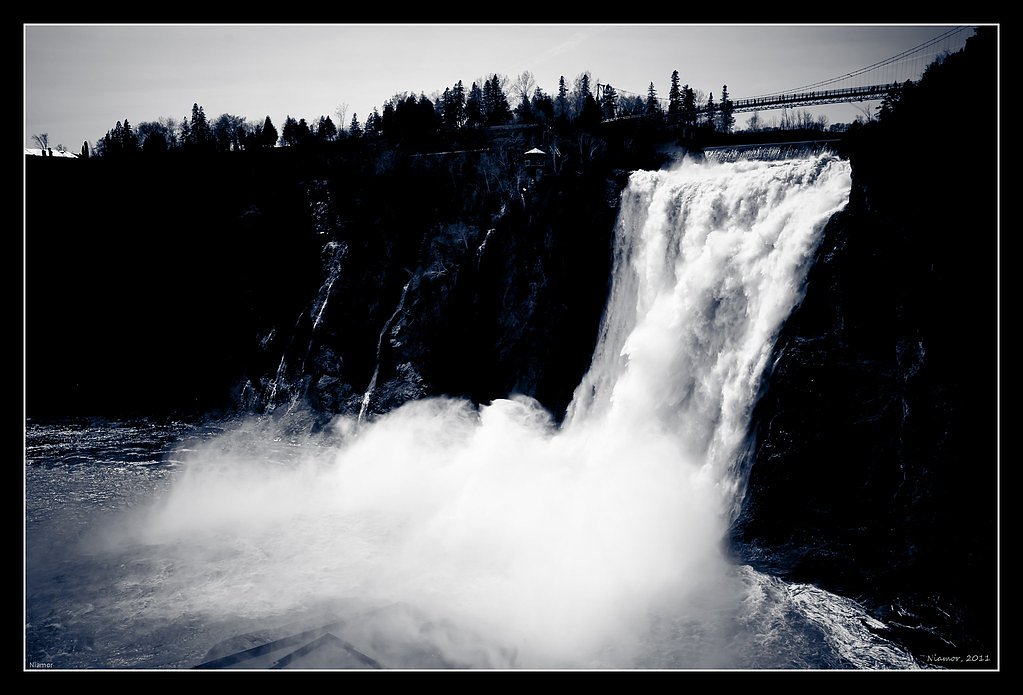
The Setting
Chute Malbaie sits at 443 metres within Hautes-Gorges-de-la-Rivière-Malbaie National Park, in the foothills of Quebec. The falls drop 10 metres.
Why This Waterfall Exists
Chute Malbaie flows over hard crystalline rock, primarily gneiss, laid down over 1.0-1.6 billion years ago. These resistant rocks form a durable ledge that water cannot easily wear away, creating a 32-foot drop where softer material downstream has already eroded.
Trail & Hike Details
Trail Description
Trail information is not well-documented in major trail databases. Approaches are likely over unmarked or minimally maintained trails or through short cross-country routes from a roadside pullout. Expect uneven footing, natural obstacles (roots, rocks), and possibly steep sections at the riverbank. If there is an established path, it is likely short but may be rough; otherwise routes may require basic route-finding skills.
What to Expect
The falls drop 10 metres over hard crystalline rock.
Accessibility
Access is likely not wheelchair accessible or suitable for people with limited mobility due to informal trails, uneven terrain, and potential steep approaches to the riverbank.
Frequently Asked Questions
🐶 Are Dogs Allowed at Chute Malbaie?
❌ Dogs are not allowed
Are There Any Fees or Permits Required?
🆖 No fees required
🏊 Is There Swimming at Chute Malbaie?
❌ Swimming is not allowed
When to Visit
Late spring (snowmelt) for highest flows and dramatic water; early fall for foliage colors and generally good weather; summer if you want warmer temperatures and easier travel. Winter visits can show impressive ice formations but require winter hiking experience and equipment.
Seasonal Access
The best time to visit is Spring, Summer, Fall, and Winter. Check with Hautes-Gorges-de-la-Rivière-Malbaie National Park for current conditions.
Safety Information
Hazards include slippery rocks, steep or unstable banks, cold fast water, changing weather, and limited cell service. Winter conditions can create hidden ice hazards and require appropriate gear. Always tell someone your plans, carry navigation aids, and avoid getting too close to edges or fast currents. If uncertain about conditions or access, use a conservative approach: assume limited infrastructure and be prepared to turn back.
7-Day Flow Outlook
Based on the WSC gauge A MARS (RIVIERE) A LA FOSSE 80 DANS LA ZEC DE LA RIVIERE A MARS (33 km away).
Best time of year: this gauge typically runs highest from mid April to late June, peaking in May.
How we calculate this
This is a transparent outlook, not a precise forecast. We take the waterfall's current flow strength (how it ranks against its historical normal for today, from the nearest WSC stream gauge), carry that ranking forward along the gauge's seasonal curve, and nudge it for forecast rain. Confidence is highest for the next day or two and falls further out. Always check official conditions and your own judgment before visiting — high flows can be dangerous.
Know when to go.
Get a free email alert when waterfalls near Chicoutimi hit peak flow. We only send when conditions are worth the trip — no weekly newsletters, no spam.
Weather Forecast
Location & Access
Getting There
Coordinates: 47.9979, -70.6752. The site is roughly 38.7 miles (≈62 km) from Chicoutimi. Access typically requires driving on secondary/forestry roads and possibly short undeveloped access trails. Visitors should use detailed maps, GPS coordinates, or local resources before setting out and confirm road conditions (seasonal forestry/maintenance closures may apply).
Get Directions on Google MapsParking
Parking may be informal (roadside pullout or small cleared area). There does not appear to be a formal developed parking lot or visitor infrastructure; expect minimal facilities.
Elevation
443 metres above sea level
Coordinates
47.997884° N, -70.675152° W
Land Management
Managed by Ministère de l'Environnement, de la Lutte contre les changements climatiques, de la Faune et des Parcs, Direction des parcs
Visitor Tips & Gear
• Use the provided coordinates and a reliable GPS/OSM map; cell coverage may be limited. • Wear sturdy, waterproof footwear with good traction, rocks and roots get slippery. • Bring layers; weather can change quickly in the region. • Expect no restroom or trash facilities, pack out what you bring in. • Be cautious near edges and fast water; banks can be unstable. • Check local forestry/park service bulletins for road closures or advisories before traveling. • If unsure about access or trail conditions, contact local visitor centers (e.g., Chicoutimi/Saguenay) for recent reports.
Where to Stay
Browse vacation cabins and private rentals nearby
Unique outdoor stays — tents, yurts, and treehouses
Rent a campervan or RV for your waterfall road trip
Some links are affiliate links. We may earn a commission at no extra cost to you.
Nearby Campground
Camping du Petit Lac Ha! Ha!
7.6 km away
Additional Information
Nearby Attractions
Saguenay Fjord (Parc national du Fjord-du-Saguenay) and towns in the Saguenay–Lac-Saint-Jean region such as Chicoutimi and La Baie are regional attractions. Local lakes, rivers, and forested areas offer additional outdoor recreation opportunities.
Wildlife
Typical regional wildlife may include moose, white-tailed deer, beaver, black bear, foxes, and a variety of songbirds and raptors. Take standard precautions for bears (store food securely, make noise while hiking).
Cities near Chute Malbaie
Nearby Waterfalls
Writing about Chute Malbaie? Embed this waterfall on your site for free.