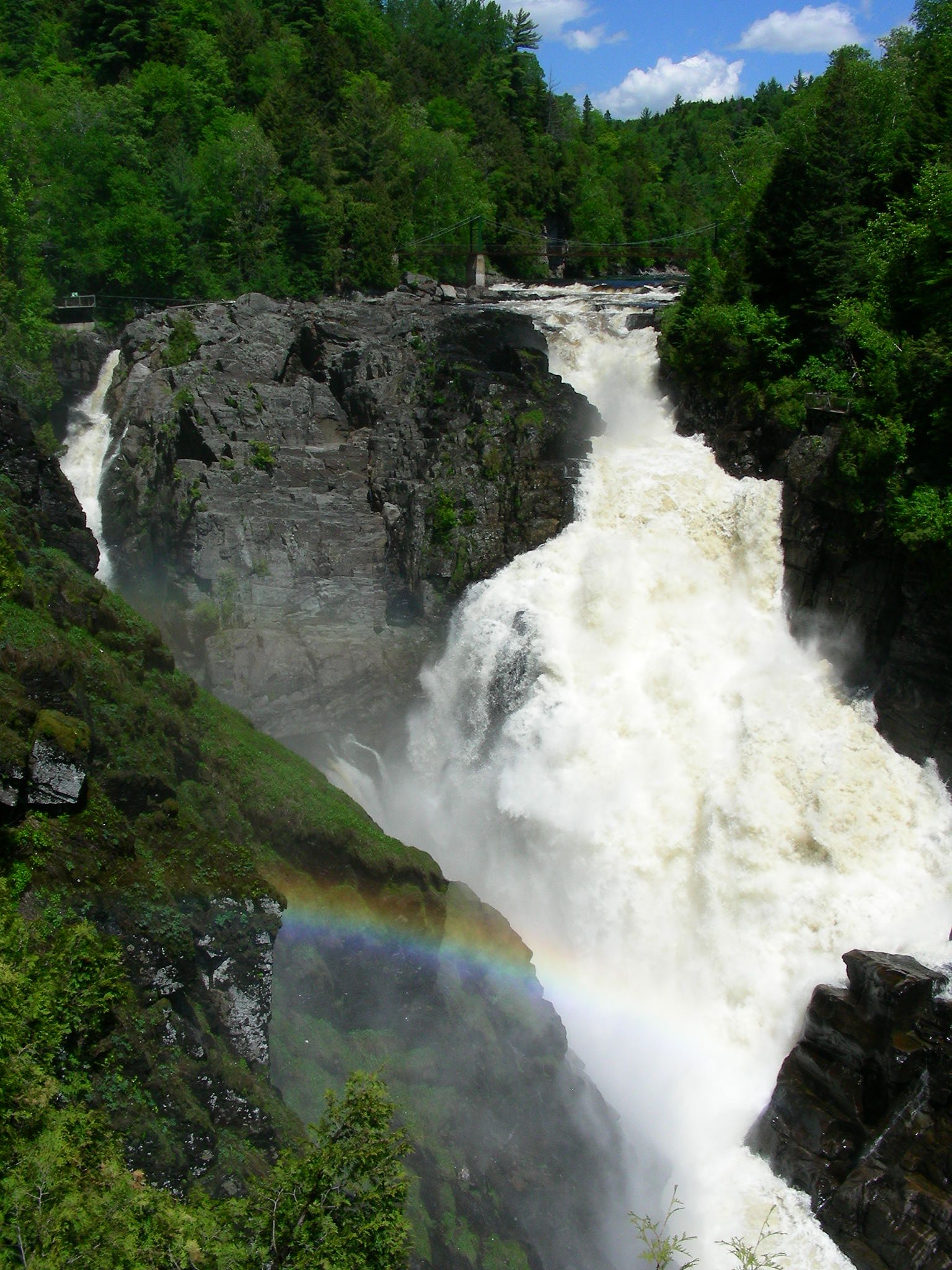
Chute de la Migmatite
Quebec • Cap Tourmente National Wildlife Area • 15 m
By Armen Suny · Last verified Jun 2026
Difficulty
Moderate
Trail Length
4.7 km
Trail Type
Out And Back
Elevation Gain
240 m
About Chute de la Migmatite
Chute de la Migmatite is a forested, likely multi-step waterfall located northeast of Québec City (approx. 33.6 miles / ~54 km from Québec). The fall sits in a rugged, wooded landscape and is best-known locally for seasonal flow variation (high flows in spring melt) and scenic forest surroundings. Precise published height and official route information are limited; visitors should treat local descriptions as approximate and confirm conditions before travel.
The Setting
Chute de la Migmatite sits at 176 metres within Cap Tourmente National Wildlife Area, in the foothills of Quebec. The falls drop 15 metres.
Why This Waterfall Exists
Chute de la Migmatite flows over layered sedimentary rock laid down about 252-539 million years ago. Over time, the stream has worn through these layers at different rates, creating a 49-foot drop that forms the waterfall.
Nearby Falls Worth Visiting
Chute Sainte-Anne (74 m) lies 7.1 kilometres to the west. Also nearby: Chute de la Friponne (25 m, 0.0 km).
Trail & Hike Details
The Approach
The moderate 4.7-km out-and-back trail gains 240 metres of elevation on the way to the falls.
Trail Description
Publicly available trail descriptions for Chute de la Migmatite are limited. Approaches, where present, are usually unpaved footpaths through mixed forest and over uneven terrain. Trails (if maintained) may be short but can be steep or rooted/stony underfoot. Because formal signage and maintained boardwalks are not confirmed, expect a more natural, potentially rough approach and use caution near the brink and downstream pools.
What to Expect
The falls drop 15 metres over layered sedimentary rock.
Accessibility
The trail is not wheelchair accessible. Uneven terrain and elevation changes require steady footing.
Frequently Asked Questions
🐶 Are Dogs Allowed at Chute de la Migmatite?
❌ Dogs are not allowed
Are There Any Fees or Permits Required?
🆖 No fees required
🏊 Is There Swimming at Chute de la Migmatite?
❌ Swimming is not allowed
When to Visit
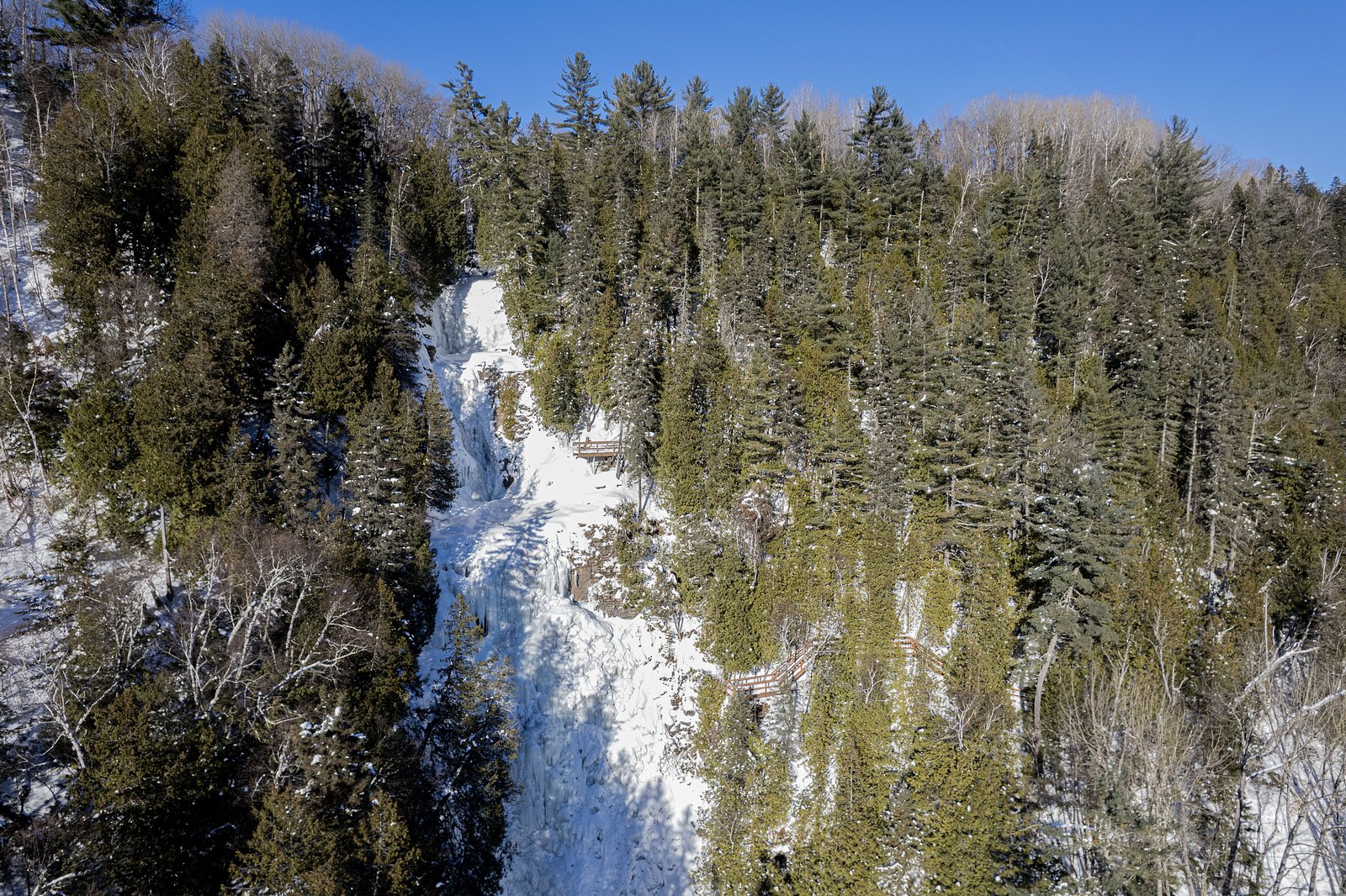
Spring (late March–May) for highest flows and dramatic water volume. Summer and fall for easier access and pleasant hiking; fall adds foliage colors. Winter offers ice and frozen-waterfall scenery but can be hazardous and may require winter gear and local knowledge.
Seasonal Access
The best time to visit is Spring, Summer, Fall, and Winter. Check with Cap Tourmente National Wildlife Area for current conditions.
Safety Information
Hazards may include slippery rocks, steep or unstable edges, cold water and strong currents, rapidly changing flow after rain or thaw, limited cell coverage, and winter ice. Do not climb wet or algae-covered rocks. Keep children and pets well supervised. Check local weather and stream conditions before visiting. If unsure about conditions or route, contact local municipal offices or regional park authorities for guidance.
7-Day Flow Outlook
Based on the WSC gauge DU SUD (RIVIERE) A 1,0 KM EN AMONT DU PONT-ROUTE A ARTHURVILLE (30 km away).
Best time of year: this gauge typically runs highest from late March to early June, peaking in April.
How we calculate this
This is a transparent outlook, not a precise forecast. We take the waterfall's current flow strength (how it ranks against its historical normal for today, from the nearest WSC stream gauge), carry that ranking forward along the gauge's seasonal curve, and nudge it for forecast rain. Confidence is highest for the next day or two and falls further out. Always check official conditions and your own judgment before visiting — high flows can be dangerous.
Know when to go.
Get a free email alert when waterfalls near Québec hit peak flow. We only send when conditions are worth the trip — no weekly newsletters, no spam.
Weather Forecast
Location & Access
Getting There
Coordinates: 47.0856, -70.7853. The waterfall is located northeast of Québec City (approx. 33.6 miles / ~54 km). Access typically requires driving on regional and local roads; final approach may be on unpaved forest or logging roads. Mobile phone coverage may be intermittent near the site. Confirm local access advisories with municipal or regional park authorities before visiting.
Get Directions on Google MapsParking
Parking is likely informal and limited, expect a pullout or small unmarked parking area rather than a developed lot. Park off the road safely and avoid blocking farm or forestry access. Parking details are not well-documented; visitors should be prepared for minimal facilities.
Elevation
176 metres above sea level
Coordinates
47.085621° N, -70.785274° W
Land Management
Managed by Canadian Wildlife Service, Quebec Region
Visitor Tips & Gear
• Check local municipal or regional tourism websites or contact local authorities for up-to-date access info before you go. • Wear sturdy, waterproof footwear with good traction, approaches are likely uneven and slippery. • Keep dogs on leash and under control; bring waste bags and pack out trash. • Respect private property and forestry operations, some approaches may cross or run adjacent to private or managed lands. • Be cautious near the water: currents, undertows, and slippery rock surfaces are hazards. Avoid getting too close to the edge. • In winter, trails and access roads may be icy or closed; bring traction devices and warm layers.
As an Amazon Associate, we earn from qualifying purchases.
With 4.7 km and 240 m of elevation gain, sturdy boots and trekking poles will help on this moderate trail. Icy conditions are common in winter — traction cleats are a smart addition.

Columbia Watertight II Rain Jacket
Packs into its own pocket, seam-sealed, and keeps you dry from spray and surprise rain.

Earth Pak Waterproof Dry Bag
Keeps your phone and gear dry when waterfall mist soaks everything else.

Waterproof Phone Pouch (AiRunTech)
Cheap insurance — take photos right next to the falls without killing your phone.

Timberland Euro Sprint Mid Waterproof
Trusted waterproof boot with premium leather and grippy rubber sole — reliable on rocky, wet trails.

TrailBuddy Trekking Poles
Lightweight aluminum, cork grips, and flip-locks that actually hold — a best-seller for good reason.

Kahtoola MICROspikes
Cult-favorite traction cleats that grip ice and wet rock — essential for winter waterfall hikes.
Where to Stay
Browse vacation cabins and private rentals nearby
Unique outdoor stays — tents, yurts, and treehouses
Rent a campervan or RV for your waterfall road trip
Some links are affiliate links. We may earn a commission at no extra cost to you.
Nearby Campground
Camping de la Pointe
7.5 km away
Additional Information
Nearby Attractions
The site is located in a rural, forested region northeast of Québec City (approx. 33.6 miles). Nearby regional attractions may include local rivers, forested trails, and small municipalities, confirm specific nearby parks and attractions with regional tourism resources for the Charlevoix/upper St. Lawrence area or the relevant administrative region.
Wildlife
Typical eastern Quebec wildlife may be present: white-tailed deer, beaver, foxes, small mammals, a variety of songbirds and waterfowl, and occasional black bear. Exercise standard wildlife precautions (secure food, keep distance).
Cities near Chute de la Migmatite
Nearby Waterfalls
Writing about Chute de la Migmatite? Embed this waterfall on your site for free.