Photo Credits (1)
Difficulty
Easy
Trail Length
4.0 km
Trail Type
Loop
Elevation Gain
116 m
About Chute Blanche
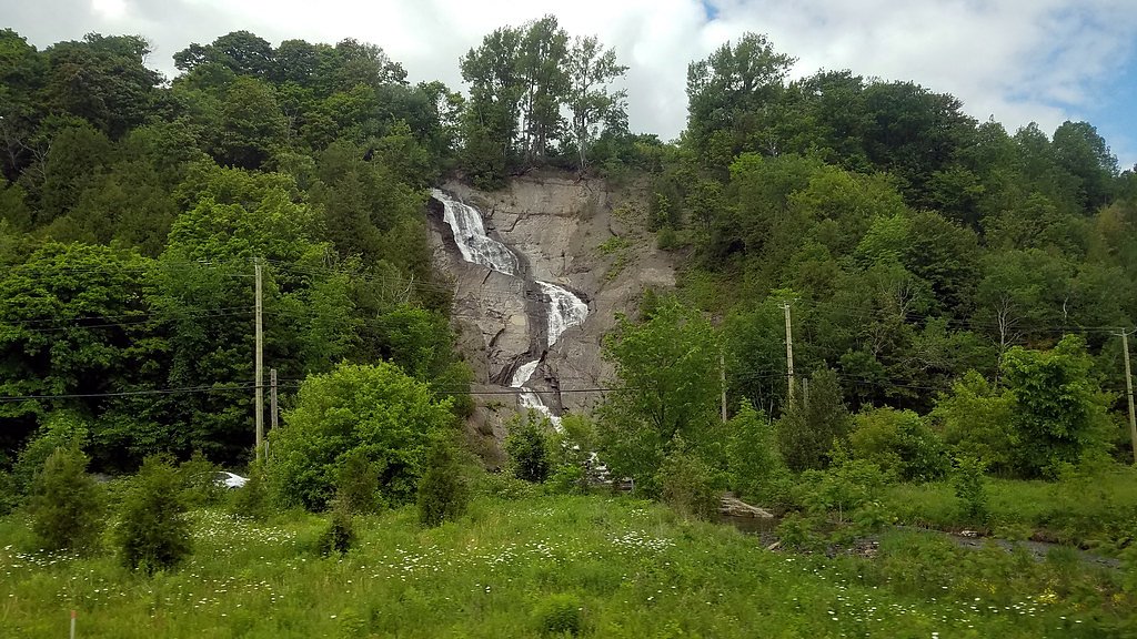
Chute Blanche is a forested-region waterfall in the Saguenay–Lac-Saint-Jean area of Québec near Dolbeau-Mistassini and Chicoutimi. The falls sit in a largely natural setting reachable via local and forestry roads; seasonal flow and appearance vary considerably (strongest in spring runoff and after heavy rain). Exact developed facilities and infrastructure at the site appear minimal and visitors should expect a rustic trail and natural viewing areas rather than developed viewpoints.
Why This Waterfall Exists
Chute Blanche flows over hard crystalline rock, primarily gneiss, laid down over 1.0-1.6 billion years ago. These resistant rocks form a durable ledge that water cannot easily wear away, creating the falls where softer material downstream has already eroded.
Trail & Hike Details
The Approach
The easy 4.0-km loop trail gains 116 metres of elevation on the way to the falls.
Trail Description
Trail and access routes are not extensively developed or signed. Expect a forested approach on an informal footpath or short spur from a forestry road; terrain may be uneven, muddy in wet seasons, and include roots, rocks, or steep sections near the falls. There may be minimal or no constructed viewpoints, handrails, or boardwalks. Trail length, elevation gain and precise route are not well documented, visitors should be prepared for a rustic hike and use map/GPS coordinates to locate the falls.
What to Expect
A natural, wooded setting with a waterfall whose appearance changes by season. Spring runoff will produce higher flow; summer may have lower flow depending on precipitation. The immediate area may have steep, slippery rock edges and slick surfaces near the water. Limited facilities: likely no restrooms, signage, or maintained viewpoints. Cell service may be limited in parts of the approach.
Accessibility
The trail is not wheelchair accessible. Uneven terrain and elevation changes require steady footing.
Frequently Asked Questions
🐶 Are Dogs Allowed at Chute Blanche?
❌ Dogs are not allowed
Are There Any Fees or Permits Required?
🆖 No fees required
🏊 Is There Swimming at Chute Blanche?
❌ Swimming is not allowed
When to Visit
Late spring (high flow from snowmelt) and early summer offer robust water flow; fall provides colorful foliage. Winter can produce impressive ice formations but access is more hazardous (deep snow, ice) and requires winter equipment and experience.
Seasonal Access
The best time to visit is Spring, Summer, Fall, and Winter. Check with the managing park or local authority for current conditions.
Safety Information
Hazards include slippery rocks and cliffs, fast or cold water currents, changing weather, limited cell reception, and the potential for forestry traffic. In winter, ice and deep snow create additional hazards (fall risk, exposure). Always keep a safe distance from cliff edges and the waterfall lip. If visiting during or after heavy rain, expect higher flows and faster currents; approach with extreme caution or postpone your visit. If unsure of road conditions, check local municipal or forestry service advisories before travel.
7-Day Flow Outlook
Based on the WSC gauge METABETCHOUANE (RIVIERE) EN AMONT DE LA CENTRALE S.R.P.C. (14 km away).
Best time of year: this gauge typically runs highest from mid April to late June, peaking in May.
How we calculate this
This is a transparent outlook, not a precise forecast. We take the waterfall's current flow strength (how it ranks against its historical normal for today, from the nearest WSC stream gauge), carry that ranking forward along the gauge's seasonal curve, and nudge it for forecast rain. Confidence is highest for the next day or two and falls further out. Always check official conditions and your own judgment before visiting — high flows can be dangerous.
Know when to go.
Get a free email alert when waterfalls near Dolbeau hit peak flow. We only send when conditions are worth the trip — no weekly newsletters, no spam.
Weather Forecast
Location & Access
Getting There
Coordinates: 48.2534, -71.9615. The site is in the Saguenay–Lac‑Saint‑Jean region, approximately 41.5 miles from Dolbeau‑Mistassini and 47.5 miles from Chicoutimi (distances as provided). Access typically involves driving on secondary and forestry/gravel roads; a high‑clearance vehicle may be helpful. Expect limited signage and the need to follow local logging or access roads and trails. Confirm local road conditions before travel, especially in spring thaw or after storms.
Get Directions on Google MapsParking
Parking is likely to be informal: small pullouts or roadside parking on a forest road rather than a developed lot. Parking may be limited and may require walking along an access road. There may be no official maintained parking or facilities.
Elevation
259 metres above sea level
Coordinates
48.253400° N, -71.961507° W
Visitor Tips & Gear
• Use the provided coordinates and a reliable map/GPS; trailheads and access roads may be unsigned. • Wear sturdy, waterproof footwear with good traction, rocks near the falls are slippery. • Check local forestry activity and road conditions before traveling; some routes may be closed for logging. • Leave no trace: pack out trash and avoid disturbing vegetation and shoreline. • Tell someone your plans and expected return time; cell coverage may be unreliable. • Be careful near edges; do not climb onto wet, mossy rocks or unstable ledges.
As an Amazon Associate, we earn from qualifying purchases.
This easy 4.0 km hike is straightforward — comfortable trail shoes and plenty of water should do. Icy conditions are common in winter — traction cleats are a smart addition.

Columbia Watertight II Rain Jacket
Packs into its own pocket, seam-sealed, and keeps you dry from spray and surprise rain.

Polarized Sunglasses (Knockaround)
Cuts glare off the water so you actually see the falls — and your photos turn out better too.

Earth Pak Waterproof Dry Bag
Keeps your phone and gear dry when waterfall mist soaks everything else.

Waterproof Phone Pouch (AiRunTech)
Cheap insurance — take photos right next to the falls without killing your phone.

Kahtoola MICROspikes
Cult-favorite traction cleats that grip ice and wet rock — essential for winter waterfall hikes.

JOBY GorillaPod Starter Kit
Wraps around railings and rocks for long-exposure waterfall shots — no flat surface needed.
Where to Stay
Browse vacation cabins and private rentals nearby
Unique outdoor stays — tents, yurts, and treehouses
Rent a campervan or RV for your waterfall road trip
Some links are affiliate links. We may earn a commission at no extra cost to you.
Nearby Campground
Camping municipal de Saint-François-de-Sales
15.6 km away
Additional Information
Nearby Attractions
Nearby towns include Dolbeau‑Mistassini and Chicoutimi (Saguenay region). The larger Saguenay–Lac‑Saint‑Jean area offers lakes, provincial parks and scenic drives; check local tourism resources for nearby parks, lookouts and cultural sites.
Wildlife
Typical regional wildlife may include white‑tailed deer, moose, beaver, small mammals and a variety of birds. Black bears are present in the region, practice bear‑aware behaviour (store food securely, make noise on the trail).
Cities near Chute Blanche
Nearby Waterfalls
Writing about Chute Blanche? Embed this waterfall on your site for free.