Difficulty
Hard
Trail Length
16.3 km
Trail Type
Out And Back
Elevation Gain
566 m
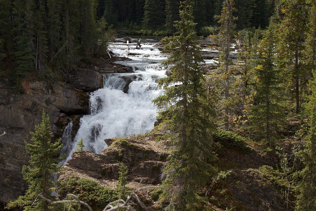
About Christina Falls
Christina Falls (coords 56.5478, -123.1076) appears to be a remote, relatively little-documented waterfall in north‑central British Columbia. Available public information is limited; the falls are likely on a small tributary and may form a multi-step cascade or single drop depending on seasonal flow. There does not appear to be an established, maintained viewpoint or formal day‑use area in most publicly available sources, so visiting typically requires travel on secondary/forestry roads and some off‑trail travel. Details such as exact vertical drop, official name usage, and formal trail access are not well documented and may vary between local maps and visitor reports.
The Setting
Christina Falls sits at 1,016 metres within GRAHAM-LAURIER PARK, in the mountains of British Columbia.
Why This Waterfall Exists
Christina Falls flows over layered sedimentary rock laid down about 201-252 million years ago. Over time, the stream has worn through these layers at different rates, creating the step that forms the waterfall.
Trail & Hike Details
The Approach
The hard 16.3-km out-and-back trail gains 566 metres of elevation on the way to the falls.
Trail Description
There is limited documentation of an established trail to Christina Falls. Visitors should be prepared for unmaintained routes, bushwhack sections, and variable terrain including wet ground, fallen timber, and steep banks near the stream. Route‑finding skills are likely needed; follow GPS coordinates, satellite imagery, and any local signage. If an informal social trail exists, it may be short but steep in places.
What to Expect
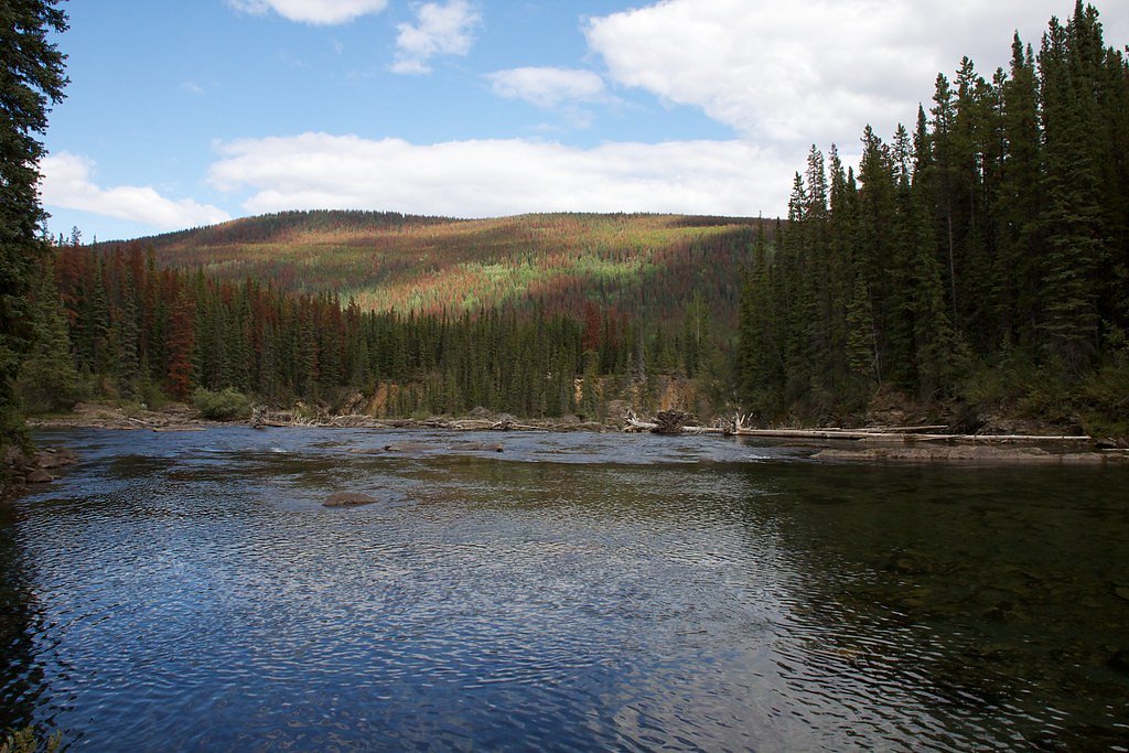
Expect a remote forested setting typical of north‑central BC: mixed coniferous forest, mossy banks, and a stream channel that may be narrow except during spring freshet. Flow can be highly seasonal, highest in spring and early summer, lower in late summer and fall. There are likely no facilities (toilets, potable water, shelters) and limited to no cell phone coverage in many parts of the region. Insects can be significant in summer; sudden weather changes are common.
Accessibility
The trail involves steep, uneven terrain with significant elevation change and is not accessible to mobility devices.
Frequently Asked Questions
🐶 Are Dogs Allowed at Christina Falls?
❌ Dogs are not allowed
Are There Any Fees or Permits Required?
🆖 No fees required
🏊 Is There Swimming at Christina Falls?
❌ Swimming is not allowed
When to Visit
Spring (late snowmelt/peak runoff) for highest flows and dramatic cascades. Early summer can still have good flow with more stable access. Fall offers lower flows and fall colours but may be less dramatic hydrologically. Winter access is likely difficult due to snow and ice and is not recommended without winter backcountry experience and appropriate gear.
Seasonal Access
The best time to visit is Spring, Summer, and Fall. Winter access may be limited. Check with the managing park or local authority for current conditions.
Safety Information
Hazards may include: unstable or slippery rocks near the falls, sudden changes in water flow, steep banks and dropoffs, fallen timber and rough undergrowth, limited cell coverage, and active forestry operations or gated roads. Road conditions on logging roads can be poor; check local resources and avoid closed or gated roads. If bears or other large wildlife are present, follow wildlife safety protocols. Carry emergency communication and plan for self‑rescue; do not rely on rapid assistance in remote areas.
Current Water Conditions
Based on a Water Survey of Canada gauge 47.2 km away
43.2 m³/s
Current discharge — how much water is flowing
About average for this time of year
Based on 42 years of record
0.30 m
Water depth at gauge
7-Day Discharge Trend
What does this mean for your visit?
Flow is about average for this time of year.
About This Gauge
This gauge is on a regional waterway. Conditions at the falls may differ, especially after local rain.
7-Day Flow Outlook
Based on the WSC gauge GRAHAM RIVER ABOVE COLT CREEK (47 km away).
Today
Moderate
47 m³/s
6/10Tomorrow
Strong
51 m³/s
7/10Tue
Moderate
51 m³/s
6/10Wed
Moderate
44 m³/s
9/10Thu
Moderate
40 m³/s
8/10Fri
Moderate
38 m³/s
8/10Sat
Moderate
41 m³/s
6/10Best window: Wed — moderate flow, sunny (trip score 9/10).
Best time of year: this gauge typically runs highest from mid May to mid August, peaking in June.
How we calculate this
This is a transparent outlook, not a precise forecast. We take the waterfall's current flow strength (how it ranks against its historical normal for today, from the nearest WSC stream gauge), carry that ranking forward along the gauge's seasonal curve, and nudge it for forecast rain. Confidence is highest for the next day or two and falls further out. Always check official conditions and your own judgment before visiting — high flows can be dangerous.
Weather Forecast
Location & Access
Getting There
The waterfall is in a remote part of north‑central British Columbia (use the provided coordinates for GPS). Access will likely require travel on secondary or forestry/logging roads; road conditions can change seasonally and after storms. A high‑clearance vehicle is typically advisable when travelling gravel forestry roads. There is limited official information about a marked trailhead; a GPS device and up‑to‑date satellite/forest service maps are recommended. Confirm access and road status with local forestry or district offices if possible.
Get Directions on Google MapsParking
There is likely no formal parking area. Expect to park at a roadside pullout or an informal clearing. Do not block gates or active logging roads. Parking availability and legality may vary; if access is across private or resource lands, permissions may be required.
Elevation
1,016 metres above sea level
Coordinates
56.547798° N, -123.107568° W
Land Management
Managed by Government of British Columbia
Visitor Tips & Gear
• Use the exact coordinates and current satellite maps to plan your route; forestry roads change frequently. • Travel with a high‑clearance or 4x4 vehicle if venturing onto gravel logging roads. • Tell someone your route and expected return time; consider carrying a satellite communicator or PLB. • Wear waterproof hiking boots; expect wet, slippery rock and root sections. • Carry insect repellent and layered clothing for variable weather. • Respect signage and private property; many access roads cross resource lands. • Pack out all trash and minimize impact, there are likely no maintained facilities.
As an Amazon Associate, we earn from qualifying purchases.
This challenging 16.3 km trail gains 566 m in elevation — come prepared with proper hiking boots and trekking poles. Sun exposure on the trail makes good sun protection a must in summer.

Sawyer Squeeze Water Filter
The backcountry standard — filters 99.9% of bacteria and weighs just 3 oz.

Polarized Sunglasses (Knockaround)
Cuts glare off the water so you actually see the falls — and your photos turn out better too.

Columbia Watertight II Rain Jacket
Packs into its own pocket, seam-sealed, and keeps you dry from spray and surprise rain.

Earth Pak Waterproof Dry Bag
Keeps your phone and gear dry when waterfall mist soaks everything else.

Waterproof Phone Pouch (AiRunTech)
Cheap insurance — take photos right next to the falls without killing your phone.

Timberland Euro Sprint Mid Waterproof
Trusted waterproof boot with premium leather and grippy rubber sole — reliable on rocky, wet trails.
Where to Stay
Browse vacation cabins and private rentals nearby
Unique outdoor stays — tents, yurts, and treehouses
Rent a campervan or RV for your waterfall road trip
Some links are affiliate links. We may earn a commission at no extra cost to you.
Additional Information
Nearby Attractions
Specific nearby attractions are not well documented for this immediate coordinate. The broader region of north‑central BC offers lakes, rivers, fishing, and backcountry recreation; consult regional tourism resources for nearby communities and additional sites.
Wildlife
Typical north‑central BC wildlife may be present: black bear (and potentially grizzly in parts of the region), moose, deer, wolves, and smaller mammals and birds. Take standard bear‑country precautions (make noise, store food properly, carry bear spray).
Other waterfalls named Christina Falls
1 other waterfall shares this name across Canada.
Writing about Christina Falls? Embed this waterfall on your site for free.