Difficulty
Easy
Trail Length
2.4 km
Trail Type
Loop
Elevation Gain
73 m
About Cascades Sainte-Anne
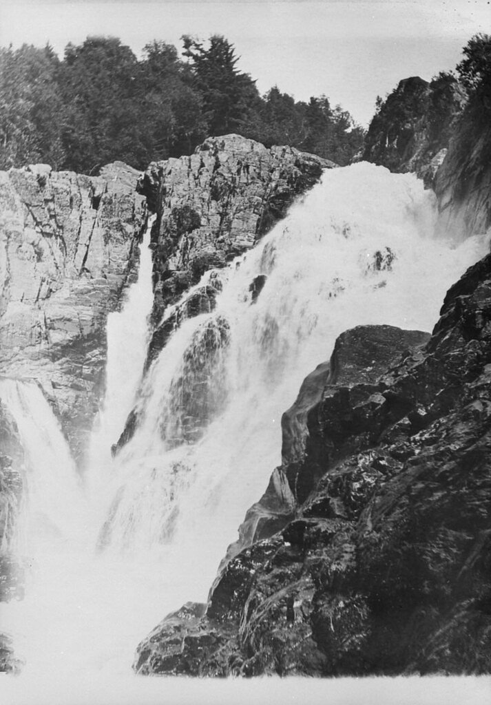
Cascades Sainte-Anne is a series of waterfalls and cascades located on a tributary in the Gaspésie region of Quebec near the municipality of Cap‑Chat (coordinates: 48.8501, -66.0946). The site is a natural, forested setting typical of the northern Gaspé peninsula with rocky ledges, pools, and seasonal variation in flow. Specific infrastructure at the site (boardwalks, viewing platforms) may be limited or non-existent; access often involves walking on informal or natural trails. Details below are conservative where official information is not widely published.
Why This Waterfall Exists
Cascades Sainte-Anne flows over layered sedimentary rock laid down about 252-539 million years ago. Over time, the stream has worn through these layers at different rates, creating the step that forms the waterfall.
Trail & Hike Details
The Approach
The easy 2.4-km loop trail gains 73 metres of elevation on the way to the falls.
Trail Description
There may be a short natural trail or an informal path from the parking/pullout down to river viewpoints and cascades. Terrain is commonly uneven with roots, rocks and potentially steep sections close to the water. Some vantage points may require a short scramble over rocks; approach edges with caution. If a maintained trail exists it is likely short (viewpoints rather than a long hike), but authoritative trail listings and recent visitor reports should be checked for confirmation.
What to Expect
Expect a forested setting with rocky river channels and multiple drops/cascades rather than a single tall plunge. Flow is highest in spring (snowmelt) and after heavy rains; summer can have lower flow. In winter the falls may form significant ice features but access will be icy and potentially hazardous. Facilities are likely minimal, bring water and plan for no services. Cell coverage may be spotty in remote sections of the Gaspésie peninsula.
Accessibility
The trail is not wheelchair accessible. Uneven terrain and elevation changes require steady footing.
Frequently Asked Questions
🐶 Are Dogs Allowed at Cascades Sainte-Anne?
❌ Dogs are not allowed
Are There Any Fees or Permits Required?
🆖 No fees required
🏊 Is There Swimming at Cascades Sainte-Anne?
❌ Swimming is not allowed
When to Visit
Late spring (peak snowmelt) for highest flows and dramatic water volume; early summer for comfortable temperatures and green scenery. Fall offers colorful foliage but can be wetter and cooler. Winter provides frozen/icefall views but is hazardous and requires winter travel experience and equipment.
Seasonal Access
The best time to visit is Spring, Summer, Fall, and Winter. Check with the managing park or local authority for current conditions.
Safety Information
Hazards include slippery rocks, steep or unstable edges, strong currents, cold water, variable weather, and limited cell coverage. Do not climb on wet rock near the edge, avoid entering fast water, and supervise children closely. In winter, ice can be brittle and dangerous; only approach frozen falls with appropriate knowledge and equipment. Always tell someone your plans and expected return time when visiting remote sites.
7-Day Flow Outlook
Based on the WSC gauge CASCAPEDIA (RIVIERE) EN AVAL DU RUISSEAU BERRY (25 km away).
Best time of year: this gauge typically runs highest from mid April to late June, peaking in May.
How we calculate this
This is a transparent outlook, not a precise forecast. We take the waterfall's current flow strength (how it ranks against its historical normal for today, from the nearest WSC stream gauge), carry that ranking forward along the gauge's seasonal curve, and nudge it for forecast rain. Confidence is highest for the next day or two and falls further out. Always check official conditions and your own judgment before visiting — high flows can be dangerous.
Know when to go.
Get a free email alert when waterfalls near Cap-Chat hit peak flow. We only send when conditions are worth the trip — no weekly newsletters, no spam.
Weather Forecast
Location & Access
Getting There
From Cap‑Chat and other nearby communities follow regional roads toward the coordinates 48.8501, -66.0946. The falls are in a relatively remote, forested portion of the Gaspésie region; reaching them typically requires turning off paved regional routes onto secondary/forestry roads and then walking a trail or path to the river. Exact driving directions and road conditions can vary seasonally, verify with local tourism offices or park/municipal resources before traveling.
Get Directions on Google MapsParking
Parking is likely informal and may be an unpaved pullout or small cleared area near the trailhead. Expect limited facilities (no formal lot, signage, or maintained restrooms in many cases). During busy seasons roadside parking may be limited; avoid blocking gates or private driveways.
Elevation
348 metres above sea level
Coordinates
48.850130° N, -66.094633° W
Visitor Tips & Gear
• Wear sturdy, grippy footwear; rocks are wet and slippery. • Check local road and weather conditions before traveling, forestry roads can be rough and seasonal. • Keep a safe distance from cliff edges and fast water; currents can be stronger than they appear. • Pack out all trash; facilities may be unavailable. • If visiting in winter, bring traction devices and be prepared for cold, icy conditions. • Confirm exact access points and permissions with local tourism offices or the nearest municipal authority; some access routes may cross private land.
As an Amazon Associate, we earn from qualifying purchases.
This easy 2.4 km hike is straightforward — comfortable trail shoes and plenty of water should do. Icy conditions are common in winter — traction cleats are a smart addition.

Columbia Watertight II Rain Jacket
Packs into its own pocket, seam-sealed, and keeps you dry from spray and surprise rain.

Polarized Sunglasses (Knockaround)
Cuts glare off the water so you actually see the falls — and your photos turn out better too.

Earth Pak Waterproof Dry Bag
Keeps your phone and gear dry when waterfall mist soaks everything else.

Waterproof Phone Pouch (AiRunTech)
Cheap insurance — take photos right next to the falls without killing your phone.

Kahtoola MICROspikes
Cult-favorite traction cleats that grip ice and wet rock — essential for winter waterfall hikes.

JOBY GorillaPod Starter Kit
Wraps around railings and rocks for long-exposure waterfall shots — no flat surface needed.
Where to Stay
Browse vacation cabins and private rentals nearby
Unique outdoor stays — tents, yurts, and treehouses
Rent a campervan or RV for your waterfall road trip
Some links are affiliate links. We may earn a commission at no extra cost to you.
Nearby Campground
Camping du Mont-Albert
9.7 km away
Additional Information
Nearby Attractions
Nearby communities and points of interest in the broader region include the town of Cap‑Chat, coastal viewpoints along Route 132, and other natural features of the Gaspésie peninsula (including portions of Parc national de la Gaspésie farther inland). Exact distances and recommended routes should be confirmed locally.
Wildlife
Typical Gaspésie wildlife includes songbirds, waterfowl, small mammals, and occasional moose or black bear. Exercise standard wildlife precautions: do not approach or feed wildlife, secure food, and keep pets under control.
Cities near Cascades Sainte-Anne
Writing about Cascades Sainte-Anne? Embed this waterfall on your site for free.