Photo Credits (3)
About Cascade
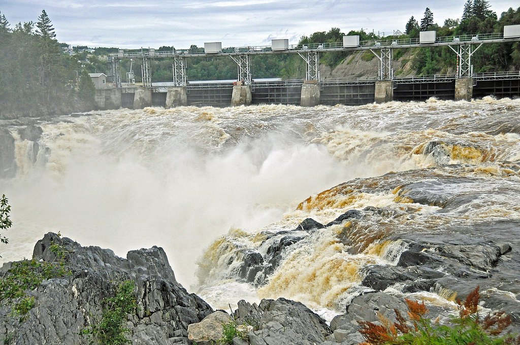
Cascade near coordinates 48.6825, -67.072 is a remote, natural waterfall feature on Quebec's North Shore region. The site is relatively undeveloped and appears to be reached by secondary/forest roads and an unmaintained or lightly maintained path. Water flow and appearance are highly seasonal, typically highest in spring snowmelt and after heavy rain; in winter portions may be frozen and inaccessible without winter skills. Specific official name, measured height, and formal trail details are not available in widely published trail sources.
Why This Waterfall Exists
Cascade flows over volcanic rock laid down about 485 million to 1.0 billion years ago. These resistant rocks form a durable ledge that water cannot easily wear away, creating the falls where softer material downstream has already eroded.
Trail & Hike Details
Trail Description
There is no widely published, maintained trail description for this specific Cascade. Access likely involves walking on an unmarked or minimally maintained path from a roadside access point and may include short bushwhacking, rocky sections, and a final scramble to view points near the falls. Trails, if present, are likely primitive and not signed. Hikers should be prepared for uneven terrain, mud, and wet, slippery rock surfaces near the water.
What to Expect
A natural, undeveloped waterfall in a remote setting. Expect variable water flow depending on season, high in spring and after rains, lower in late summer. Limited or no facilities (no restrooms, visitor center, or developed viewpoints). Cell coverage may be unreliable. Terrain near the falls is rocky and slippery; edges can be unstable. Wildlife typical of the Quebec North Shore region may be present (deer, moose, black bear, small mammals, and ticks).
Accessibility
Likely not wheelchair or stroller accessible. Expect uneven, rocky, and slippery footing; the approach may include unmaintained trails or bushwhacking.
Frequently Asked Questions
🐶 Are Dogs Allowed at Cascade?
❌ Dogs are not allowed
Are There Any Fees or Permits Required?
🆖 No fees required
🏊 Is There Swimming at Cascade?
❌ Swimming is not allowed
When to Visit
Late spring (snowmelt) typically offers the highest water flow and most dramatic appearance. Summer and early fall are good for easier access and more stable weather. Winter can produce ice formations but presents increased hazards (ice, deep snow, limited access) and should only be attempted with appropriate winter equipment and experience.
Seasonal Access
The best time to visit is Spring, Summer, Fall, and Winter. Check with the managing park or local authority for current conditions.
Safety Information
Hazards include slippery wet rock, unstable banks, fast-moving water, cold water temperatures, sudden weather changes, limited or no cell service, and potential wildlife encounters. Always tell someone your plans and expected return time. Avoid getting too close to the edge or attempting to climb wet rock. During spring runoff or after heavy rain the current can be much stronger than it appears.
7-Day Flow Outlook
Based on the WSC gauge MATAPEDIA (RIVIERE) PRES DE AMQUI (35 km away).
Best time of year: this gauge typically runs highest from mid April to early July, peaking in May.
How we calculate this
This is a transparent outlook, not a precise forecast. We take the waterfall's current flow strength (how it ranks against its historical normal for today, from the nearest WSC stream gauge), carry that ranking forward along the gauge's seasonal curve, and nudge it for forecast rain. Confidence is highest for the next day or two and falls further out. Always check official conditions and your own judgment before visiting — high flows can be dangerous.
Know when to go.
Get a free email alert when waterfalls near Cap-Chat hit peak flow. We only send when conditions are worth the trip — no weekly newsletters, no spam.
Weather Forecast
Location & Access
Getting There
Use the provided coordinates (48.6825, -67.072) to navigate. The waterfall is in a remote area roughly 36.0 miles from Cap-Chat and 71.7 miles from Baie-Comeau (user-supplied distances). Expect unpaved forest or coastal access roads; a high-clearance vehicle may be helpful. Local forestry roads can be seasonal or gated. Confirm access and road conditions with local municipal offices or provincial forestry/park authorities before travel.
Get Directions on Google MapsParking
No formal parking lot is known. Parking may be informal on a roadside pullout or at the start of an unmarked trail. Park well off the travel surface and avoid blocking gates or private driveways. If uncertain, plan to return to the nearest town to confirm legal parking locations.
Elevation
294 metres above sea level
Coordinates
48.682488° N, -67.071961° W
Visitor Tips & Gear
1) Check local access and road conditions before you go, forest roads can be gated or seasonally impassable. 2) Wear sturdy, grippy footwear and expect wet, slippery rocks. 3) Keep a safe distance from cliff edges and fast water; do not attempt to climb wet rock faces. 4) Bring a map/GPS with the coordinates and a charged phone; don’t rely solely on cell service. 5) Leave no trace, pack out all trash. 6) If wildlife is present, store food securely and give animals space.
Where to Stay
Browse vacation cabins and private rentals nearby
Unique outdoor stays — tents, yurts, and treehouses
Rent a campervan or RV for your waterfall road trip
Some links are affiliate links. We may earn a commission at no extra cost to you.
Nearby Campground
Camping du Lac-Tombereau
2.1 km away
Additional Information
Nearby Attractions
Nearest named communities (user-provided): Cap-Chat (approx. 36.0 miles) and Baie-Comeau (approx. 71.7 miles). The general region offers coastal scenery, other streams and rivers, and outdoor recreation opportunities, verify specific attractions locally.
Wildlife
Typical regional wildlife may include moose, white-tailed deer, black bear, small mammals, and a variety of birds. Ticks can be present in brushy areas. Always follow wildlife safety guidelines.
Cities near Cascade
Nearby Waterfalls
Writing about Cascade? Embed this waterfall on your site for free.