
Boundary Falls
British Columbia • 12 m
By Armen Suny · Last verified Jun 2026
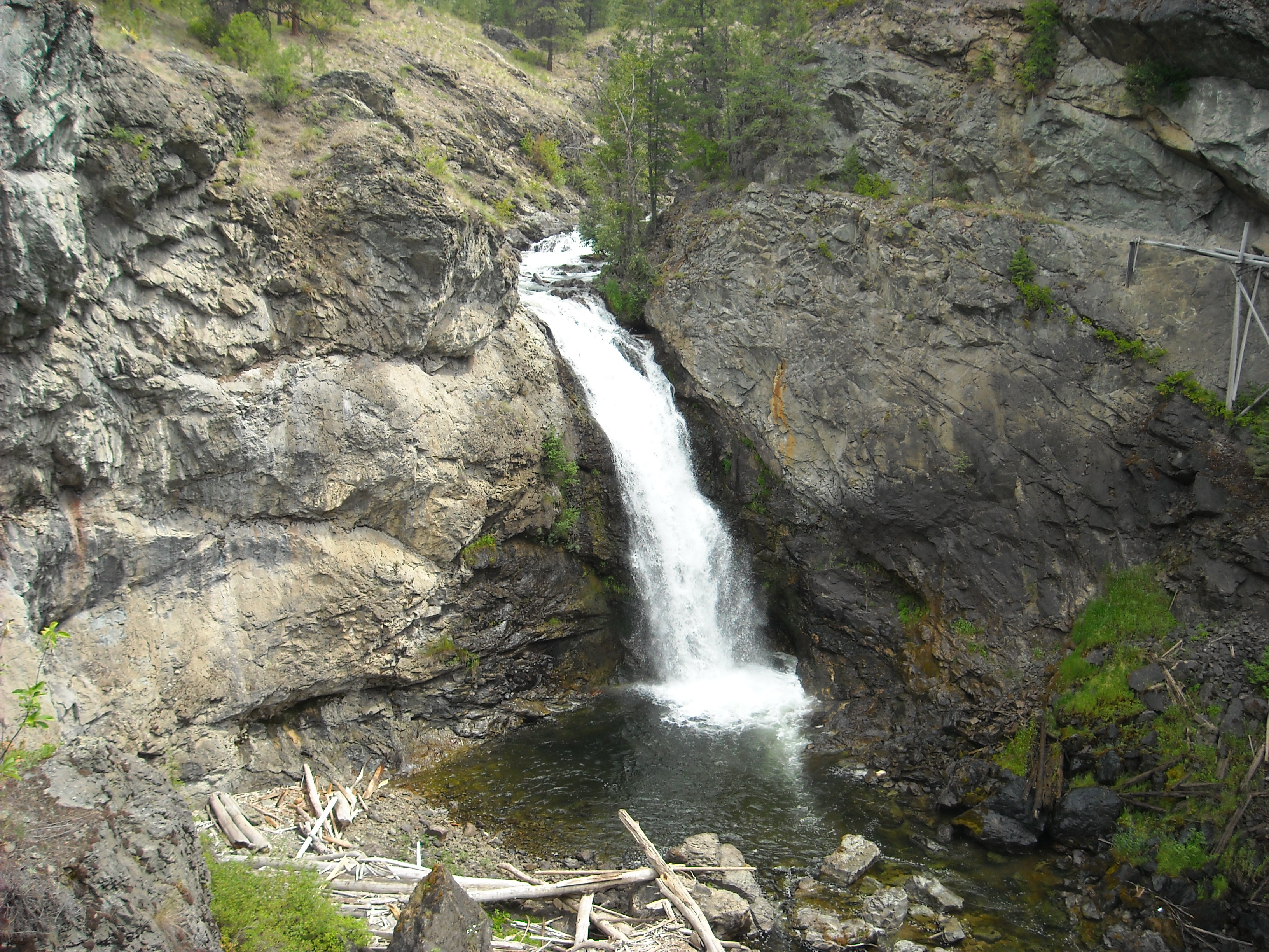
Photo Credits (3)
Difficulty
Moderate
Trail Length
0.8 km
Trail Type
Out And Back
Elevation Gain
28 m
About Boundary Falls
Boundary Falls is a medium-sized waterfall on Boundary Creek in British Columbia, Canada. Boundary Creek is a tributary of the Kettle River. It is located within a small canyon a little over halfway between Midway & Greenwood, beside the town which was named after the falls, Boundary Falls.
The Setting
Boundary Falls sits at 699 metres in the hills of British Columbia. The falls drop 12 metres.
Why This Waterfall Exists
Boundary Falls flows over hard intrusive rock laid down about 23-66 million years ago. These resistant rocks form a durable ledge that water cannot easily wear away, creating a 40-foot drop where softer material downstream has already eroded.
Trail & Hike Details
The Approach
The moderate 0.8-km out-and-back trail gains 28 metres of elevation on the way to the falls.
Trail Description
Trail details are not well-documented in major trail databases. Expect an informal approach that may be a short walk from a roadside pullout or a rough forest track. The path, where present, may be uneven, muddy, and include roots and rocks. Signage and developed viewpoints may be limited or absent. Follow obvious game or user trails with caution and respect private property boundaries.
What to Expect
The falls drop 12 metres over hard intrusive rock.
Accessibility
The trail is not wheelchair accessible. Uneven terrain and elevation changes require steady footing.
Frequently Asked Questions
🐶 Are Dogs Allowed at Boundary Falls?
❌ Dogs are not allowed
Are There Any Fees or Permits Required?
🆖 No fees required
🏊 Is There Swimming at Boundary Falls?
❌ Swimming is not allowed
When to Visit
Late spring to early summer for highest flows and lush vegetation. Fall can provide pleasant colors and fewer insects. Winter access may be difficult and icy, visit only if well-prepared and aware of conditions.
Seasonal Access
The best time to visit is Spring, Summer, Fall, and Winter. Check with the managing park or local authority for current conditions.
Safety Information
Hazards can include slippery rocks, fast or cold water currents, steep or unstable edges, falling rock/trees in logged areas, limited cell service, and seasonal road/trail closures. Seasonal high flows can produce strong currents and undercut banks. Always stay back from edges, supervise children closely, and avoid entering the water unless you are certain it is safe. Check local conditions and weather before traveling. If uncertain about access or safety, contact local authorities or a visitor centre.
Current Water Conditions
0.2 m³/s
Current discharge — how much water is flowing
1.36 m
Water depth at gauge
7-Day Discharge Trend
About This Gauge
7-Day Flow Outlook
Based on the WSC gauge BOUNDARY CREEK NEAR BOUNDARY FALLS (1 km away).
Today
Moderate
0.2 m³/s
9/10Tomorrow
Moderate
0.2 m³/s
8/10Tue
Moderate
0.2 m³/s
8/10Wed
Moderate
0.2 m³/s
8/10Thu
Moderate
0.2 m³/s
6/10Fri
Moderate
0.2 m³/s
9/10Sat
Moderate
0.2 m³/s
9/10Best window: Today — moderate flow, sunny (trip score 9/10).
How we calculate this
This is a transparent outlook, not a precise forecast. We take the waterfall's current flow strength (how it ranks against its historical normal for today, from the nearest WSC stream gauge), carry that ranking forward along the gauge's seasonal curve, and nudge it for forecast rain. Confidence is highest for the next day or two and falls further out. Always check official conditions and your own judgment before visiting — high flows can be dangerous.
Know when to go.
Get a free email alert when waterfalls near Penticton hit peak flow. We only send when conditions are worth the trip — no weekly newsletters, no spam.
Weather Forecast
Location & Access
Getting There
From the general area: use local roads off BC provincial routes serving Boundary Country. The falls are in a rural area near Danville (≈10.6 miles), Curlew (≈12.2 miles), and Malo (≈15.7 miles). Coordinates: 49.0378, -118.7072, use a reliable GPS or mapping app. Roads may be gravel and seasonally maintained; low-clearance vehicles may be unsuitable on spur roads. Check with local visitor centres or the regional district for up-to-date road/access information.
Get Directions on Google MapsParking
There may be informal roadside parking or a small pullout near the trail/start. Parking appears to be limited and likely unpaved; do not block gates, driveways, or forestry operations. If access crosses private property, parking rules may vary, confirm before leaving vehicles.
Elevation
699 metres above sea level
Coordinates
49.037807° N, -118.707165° W
Visitor Tips & Gear
• Confirm legal public access before visiting; some approaches may cross private land. • Wear sturdy, waterproof footwear, approach can be slippery and uneven. • Bring insect repellent in warmer months. • Leave no trace: pack out all trash and toilet waste. • Avoid getting close to the edge of drops or climbing wet rocks, they can be extremely slippery. • If visiting in winter, expect icy conditions and limited access; use traction devices and dress warmly. • Check local road conditions (gravel roads may be seasonally closed or rough).
As an Amazon Associate, we earn from qualifying purchases.
With 0.8 km and 28 m of elevation gain, sturdy boots and trekking poles will help on this moderate trail. Icy conditions are common in winter — traction cleats are a smart addition.

Columbia Watertight II Rain Jacket
Packs into its own pocket, seam-sealed, and keeps you dry from spray and surprise rain.

Polarized Sunglasses (Knockaround)
Cuts glare off the water so you actually see the falls — and your photos turn out better too.

Earth Pak Waterproof Dry Bag
Keeps your phone and gear dry when waterfall mist soaks everything else.

Waterproof Phone Pouch (AiRunTech)
Cheap insurance — take photos right next to the falls without killing your phone.

Timberland Euro Sprint Mid Waterproof
Trusted waterproof boot with premium leather and grippy rubber sole — reliable on rocky, wet trails.

TrailBuddy Trekking Poles
Lightweight aluminum, cork grips, and flip-locks that actually hold — a best-seller for good reason.
Where to Stay
Browse vacation cabins and private rentals nearby
Unique outdoor stays — tents, yurts, and treehouses
Rent a campervan or RV for your waterfall road trip
Some links are affiliate links. We may earn a commission at no extra cost to you.
Nearby Campground
Boundary Creek Provincial Campground
2.4 km away
Nearby Hot Springs
Hot springs near Penticton, British Columbia
Hot Lake
Hot Lake reaches 122 degrees at 1,902 feet elevation on Bureau of Land Management property in Okanogan County, producing water ...
Poison Lake
Poison Lake reaches 122 degrees Fahrenheit in north-central Washington's Okanogan County, creating a thermal difference of 70.7...
Looking for a soak after your hike? Explore more hot springs near Penticton, British Columbia on SoakingSprings.
Explore British Columbia springsAdditional Information
Nearby Attractions
Nearby towns and attractions in Boundary Country and the Kettle River region, including local parks, lakes (e.g., Christina Lake a short drive away), and small historic communities. Grand Forks and other regional points of interest are reachable by vehicle.
Wildlife
Common local species may include deer, small mammals, squirrels, numerous bird species, and potentially black bear. Take standard wildlife precautions: do not approach or feed animals, properly store food, and make noise when appropriate to avoid surprising wildlife.
Cities near Boundary Falls
Writing about Boundary Falls? Embed this waterfall on your site for free.