Photo Credits (2)
Difficulty
Easy
Trail Length
0.3 km
Trail Type
Out And Back
Elevation Gain
6 m
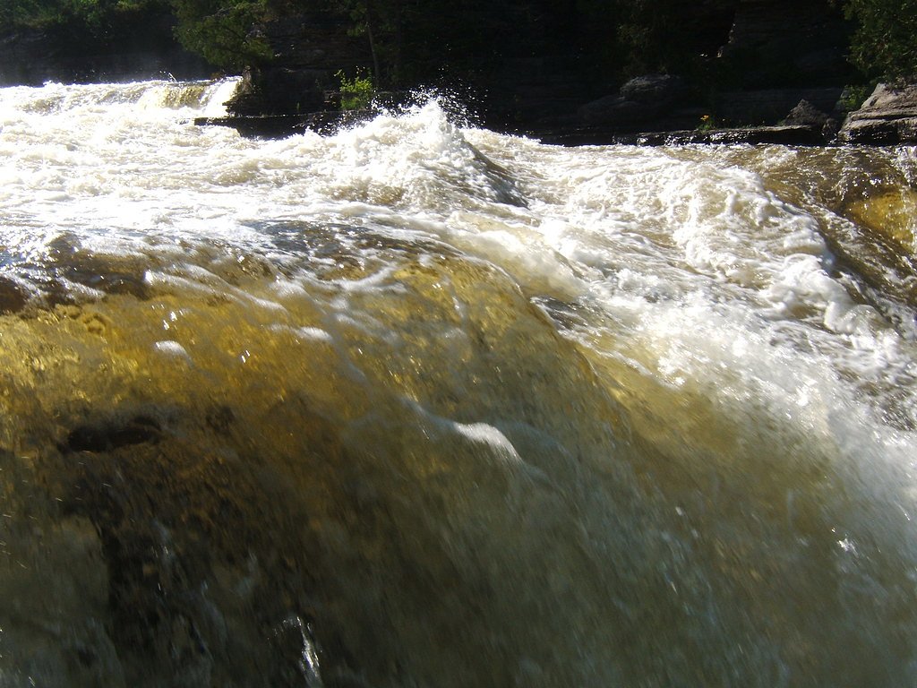
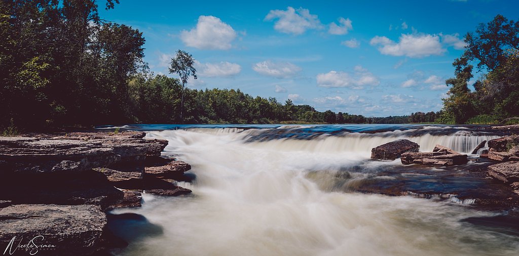
About Bonnechere Falls
Bonnechere Falls is a set of falls/rapids on the Bonnechere River in Renfrew County, Ontario, adjacent to the small community area and municipal park. The site features short, developed viewpoints and a boardwalk/parking area providing easy views of the river and falls. Flow and appearance vary substantially by season and recent precipitation; spring melt typically produces the highest flows.
Why This Waterfall Exists
Bonnechere Falls flows over Flinton Group, a hard metamorphic rock layer deposited about 539 million to 1.6 billion years ago. These resistant rocks form a durable ledge that water cannot easily wear away, creating the falls where softer material downstream has already eroded.
Trail & Hike Details
The Approach
The easy 0.3-km out-and-back trail gains 6 metres of elevation on the way to the falls.
Trail Description
A very short, mainly paved or boardwalk-style approach from the parking area brings you to viewing platforms and river-edge vantage points. Trails are short and intended for sightseeing rather than long hikes. Some sections may include a few steps or uneven rock near the waterline.
What to Expect
Short walk from parking to developed viewing platforms. Expect rocky shorelines, wet and potentially slippery surfaces near the water, and variable water levels, high in spring and after heavy rain, lower in late summer. Facilities are basic (parking, picnic/park benches possible). In winter, parts of the site may be icy or covered with snow; frozen falls/ice formations possible but ice travel is hazardous.
Accessibility
The trail is short and relatively flat, but the surface may be uneven. Contact the managing agency for accessibility details.
Frequently Asked Questions
🐶 Are Dogs Allowed at Bonnechere Falls?
❌ Dogs are not allowed
Are There Any Fees or Permits Required?
🆖 No fees required
🏊 Is There Swimming at Bonnechere Falls?
❌ Swimming is not allowed
When to Visit
Spring for highest flows and dramatic water; fall for foliage; summer for warm weather access; winter for ice scenery (but exercise caution due to ice hazards). For peak water flow and spectacle, visit during spring runoff or after significant rainfall.
Seasonal Access
The best time to visit is Spring, Summer, Fall, and Winter. Check with the managing park or local authority for current conditions.
Safety Information
Primary hazards include slippery rocks, fast currents and cold water. Do not climb on wet rocks near the edge, and supervise children at all times. In winter, ice can be unstable, avoid walking on river ice and exercise caution near frozen falls. Emergency services in rural areas may have longer response times, carry a charged phone and let someone know your plan.
Current Water Conditions
11.4 m³/s
Current discharge — how much water is flowing
About average for this time of year
Based on 104 years of record
5.81 m
Water depth at gauge
7-Day Discharge Trend
What does this mean for your visit?
Flow is about average for this time of year.
About This Gauge
7-Day Flow Outlook
Based on the WSC gauge BONNECHERE RIVER NEAR CASTLEFORD (1 km away).
Today
Moderate
11 m³/s
8/10Tomorrow
Moderate
11 m³/s
8/10Tue
Strong
12 m³/s
7/10Wed
Strong
12 m³/s
8/10Thu
Strong
11 m³/s
9/10Fri
Strong
11 m³/s
8/10Sat
Strong
12 m³/s
8/10Best window: Thu — strong flow, cloudy (trip score 9/10).
Best time of year: this gauge typically runs highest from mid March to mid June, peaking in April.
How we calculate this
This is a transparent outlook, not a precise forecast. We take the waterfall's current flow strength (how it ranks against its historical normal for today, from the nearest WSC stream gauge), carry that ranking forward along the gauge's seasonal curve, and nudge it for forecast rain. Confidence is highest for the next day or two and falls further out. Always check official conditions and your own judgment before visiting — high flows can be dangerous.
Know when to go.
Get a free email alert when waterfalls near Pembroke hit peak flow. We only send when conditions are worth the trip — no weekly newsletters, no spam.
Weather Forecast
Location & Access
Getting There
Located in the Bonnechere River corridor near Pembroke (~39.0 miles) and Ottawa (~40.4 miles). Coordinates provided: 45.5014, -76.5581. Access is by car via local municipal roads; look for signage for the Bonnechere Falls / village park area. From Ottawa or Pembroke follow provincial highways toward Renfrew County and local signage to the Bonnechere/Eganville area. Exact driving route will depend on starting point, use the provided coordinates or a trusted mapping app to navigate to the park/parking area.
Get Directions on Google MapsParking
Small municipal parking lot(s) adjacent to the falls/park. Parking is typically day-use and unsheltered; space may be limited during peak visitation. No confirmed paid parking or permit system is known, check local municipality sources for current rules.
Elevation
95 metres above sea level
Coordinates
45.501383° N, -76.558078° W
Visitor Tips & Gear
Wear sturdy, non-slip footwear; stay behind barriers and on designated paths; supervise children closely; watch for slippery rocks and variable water currents; bring insect repellent in summer. Check local municipal websites or visitor centres for any temporary closures or parking changes. If bringing dogs, expect leash rules, confirm with local signage or municipality.
As an Amazon Associate, we earn from qualifying purchases.
For this easy 0.3 km trail, lightweight trail shoes and a water bottle are usually sufficient. Icy conditions are common in winter — traction cleats are a smart addition.

Columbia Watertight II Rain Jacket
Packs into its own pocket, seam-sealed, and keeps you dry from spray and surprise rain.

Polarized Sunglasses (Knockaround)
Cuts glare off the water so you actually see the falls — and your photos turn out better too.

Earth Pak Waterproof Dry Bag
Keeps your phone and gear dry when waterfall mist soaks everything else.

Waterproof Phone Pouch (AiRunTech)
Cheap insurance — take photos right next to the falls without killing your phone.

Kahtoola MICROspikes
Cult-favorite traction cleats that grip ice and wet rock — essential for winter waterfall hikes.

JOBY GorillaPod Starter Kit
Wraps around railings and rocks for long-exposure waterfall shots — no flat surface needed.
Where to Stay
Browse vacation cabins and private rentals nearby
Unique outdoor stays — tents, yurts, and treehouses
Rent a campervan or RV for your waterfall road trip
Some links are affiliate links. We may earn a commission at no extra cost to you.
Nearby Campground
Grandview Cottages & Trailer Park
3.8 km away
Additional Information
Nearby Attractions
The broader Bonnechere River corridor and nearby village/regional attractions (e.g., local museums, caves and community parks in the Eganville/Bonnechere area) may be accessible within a short drive. Confirm exact sites and hours before planning side trips.
Wildlife
Expect typical southern Ontario wildlife in riparian areas: waterfowl, songbirds, beavers, muskrats, deer and possibly small mammals. Black bears may occur in the region but are not common immediately at roadside parks; be cautious with food and garbage.
Cities near Bonnechere Falls
Writing about Bonnechere Falls? Embed this waterfall on your site for free.