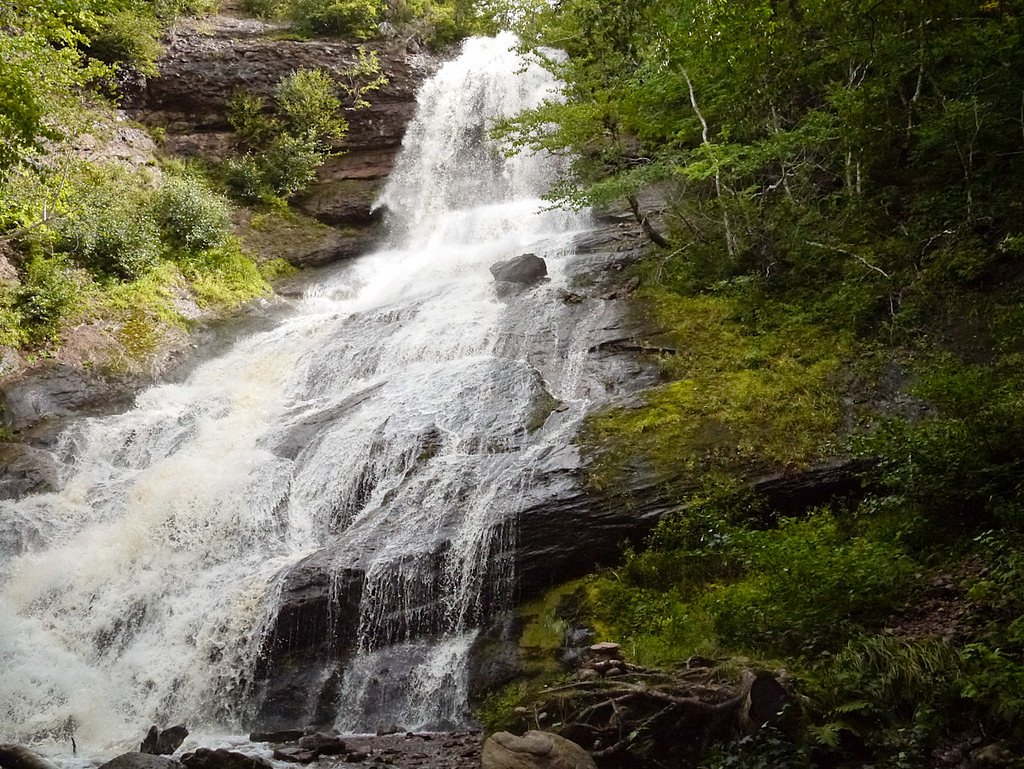
Beulach Ban Falls
Nova Scotia • Cape Breton Highlands National Park • 21 m
By Armen Suny · Last verified Jun 2026
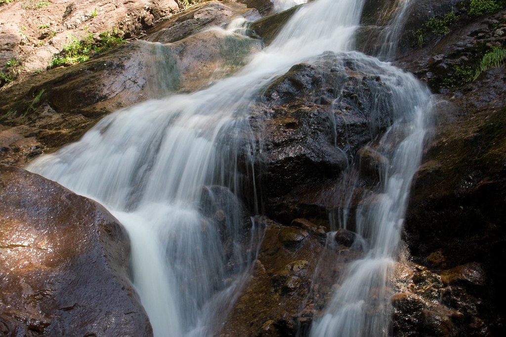
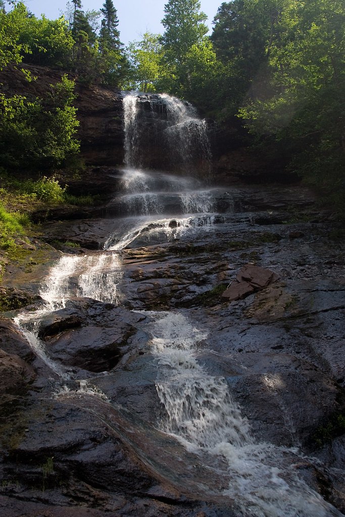
Photo Credits (5)
Difficulty
Easy
Trail Length
0.3 km
Trail Type
Out And Back
Elevation Gain
12 m
About Beulach Ban Falls
Beulach Ban Falls is a woodland waterfall on Cape Breton Island, Nova Scotia, located in a relatively remote area of the island (coordinates approx. 46.8141, -60.6253). The falls are described in local trip reports as a scenic cascade set in a narrow, rocky gorge. Detailed measurements and official descriptions are limited; the waterfall's exact height and many trail specifics are not well documented and may vary seasonally. Access typically involves a short walk from a roadside pullout or small trailhead and the site may be best-visited in spring for higher flows or in fall for color.
The Setting
Beulach Ban Falls sits at 80 metres within Cape Breton Highlands National Park, in the coastal lowlands of Nova Scotia. The falls drop 21 metres.
Why This Waterfall Exists
Beulach Ban Falls flows over hard intrusive rock laid down about 359-419 million years ago. These resistant rocks form a durable ledge that water cannot easily wear away, creating a 69-foot drop where softer material downstream has already eroded.
Nearby Falls Worth Visiting
Mackintosh Brook Falls (20 m) lies 10.3 kilometres to the west.
Trail & Hike Details
The Approach
The easy 0.3-km out-and-back trail gains 12 metres of elevation on the way to the falls.
Trail Description
Trail and access details are not consistently documented. Trip reports indicate a short walk from a roadside pullout down a wooded, potentially steep or rocky path to a viewing area at the gorge. The route may be unmarked and involve uneven footing, roots, wet rocks and mud. There may be no official maintained trail or boardwalk; route-finding skills could be needed.
What to Expect
The falls drop 21 metres over hard intrusive rock.
Accessibility
The trail is short and relatively flat, but the surface may be uneven. Contact the managing agency for accessibility details.
Frequently Asked Questions
🐶 Are Dogs Allowed at Beulach Ban Falls?
❌ Dogs are not allowed
Are There Any Fees or Permits Required?
🆖 No fees required
🏊 Is There Swimming at Beulach Ban Falls?
❌ Swimming is not allowed
When to Visit
Spring (late March–May) for highest water flow and dramatic cascades; early fall for foliage color and comfortable temperatures. Summer provides easier access but potentially lower flows. Winter visits are possible but can be hazardous due to ice, snow and limited maintenance, only for experienced winter hikers with proper gear.
Seasonal Access
The best time to visit is Spring, Summer, Fall, and Winter. Check with Cape Breton Highlands National Park for current conditions.
Safety Information
Hazards can include slippery rocks, unstable or steep banks, fast-flowing water (especially in spring), limited cell service, and unmarked or unmaintained trails. Do not attempt to climb on wet rocks or get too close to cliff edges. Weather on Cape Breton can change quickly, bring layers and check forecasts. If visiting alone, tell someone your plans and expected return time. For winter visits, specialized gear (microspikes, snowshoes) and experience are required due to ice and deep snow.
Current Water Conditions
Based on a Water Survey of Canada gauge 31.1 km away
1.5 m³/s
Current discharge — how much water is flowing
Much lower than usual for this time of year
Based on 64 years of record
0.92 m
Water depth at gauge
7-Day Discharge Trend
What does this mean for your visit?
Flow is well below normal for this time of year, so the waterfall may be a trickle.
About This Gauge
This gauge is on a regional waterway. Conditions at the falls may differ, especially after local rain.
7-Day Flow Outlook
Based on the WSC gauge CHETICAMP RIVER ABOVE ROBERT BROOK (31 km away).
Today
Barely Flowing
1.6 m³/s
3/10Tomorrow
Barely Flowing
1.5 m³/s
4/10Tue
Barely Flowing
1.5 m³/s
4/10Wed
Barely Flowing
1.7 m³/s
3/10Thu
Low
1.6 m³/s
4/10Fri
Low
1.8 m³/s
4/10Sat
Low
1.6 m³/s
4/10Best window: Tomorrow — barely flowing flow, cloudy (trip score 4/10).
Best time of year: this gauge typically runs highest from early April to early June, peaking in May.
How we calculate this
This is a transparent outlook, not a precise forecast. We take the waterfall's current flow strength (how it ranks against its historical normal for today, from the nearest WSC stream gauge), carry that ranking forward along the gauge's seasonal curve, and nudge it for forecast rain. Confidence is highest for the next day or two and falls further out. Always check official conditions and your own judgment before visiting — high flows can be dangerous.
Know when to go.
Get a free email alert when waterfalls near Baddeck hit peak flow. We only send when conditions are worth the trip — no weekly newsletters, no spam.
Weather Forecast
Location & Access
Getting There
From Baddeck or Sydney drive toward the general Cape Breton interior in the area of the provided coordinates (46.8141, -60.6253). The falls are in a rural area of Cape Breton Island and are reached via secondary paved and/or gravel roads; expect limited signage. Visitors should use a reliable map or GPS coordinates and plan for a final short walk from a parking/pullout area. Road and trail conditions may be rough in poor weather.
Get Directions on Google MapsParking
Parking is likely a small roadside pullout or informal parking area. There may be no formal parking lot, signage, or facilities. Parking can be limited and may require parking on a soft shoulder or gravel area, use caution and avoid blocking the road.
Elevation
80 metres above sea level
Coordinates
46.814133° N, -60.625256° W
Land Management
Managed by Parks Canada Agency
Visitor Tips & Gear
• Use the provided coordinates and a reliable map/GPS; signage may be limited or absent. • Wear sturdy waterproof footwear with good traction, rocks and the approach trail can be slippery. • Stay back from cliff edges and wet rocks; there may be no railings. • Bring water, a basic first-aid kit, and warm layers, weather can change quickly. • Leave no trace: pack out all trash. • If visiting in spring, prepare for muddy conditions and higher water flows. • If uncertain about trail conditions, defer to park/forest service or local visitor centres for current information.
As an Amazon Associate, we earn from qualifying purchases.
For this easy 0.3 km trail, lightweight trail shoes and a water bottle are usually sufficient. Icy conditions are common in winter — traction cleats are a smart addition.

Columbia Watertight II Rain Jacket
Packs into its own pocket, seam-sealed, and keeps you dry from spray and surprise rain.

Polarized Sunglasses (Knockaround)
Cuts glare off the water so you actually see the falls — and your photos turn out better too.

Earth Pak Waterproof Dry Bag
Keeps your phone and gear dry when waterfall mist soaks everything else.

Waterproof Phone Pouch (AiRunTech)
Cheap insurance — take photos right next to the falls without killing your phone.

Kahtoola MICROspikes
Cult-favorite traction cleats that grip ice and wet rock — essential for winter waterfall hikes.

JOBY GorillaPod Starter Kit
Wraps around railings and rocks for long-exposure waterfall shots — no flat surface needed.
Where to Stay
Browse vacation cabins and private rentals nearby
Unique outdoor stays — tents, yurts, and treehouses
Rent a campervan or RV for your waterfall road trip
Some links are affiliate links. We may earn a commission at no extra cost to you.
Nearby Campground
Big Intervale Campground
2 km away
Additional Information
Nearby Attractions
Nearby regional points of interest on Cape Breton Island may include the Cabot Trail, Baddeck and the Bras d'Or Lake region, Cape Breton Highlands National Park (depending on exact routing). Use local visitor centres in Baddeck or Sydney for up-to-date suggestions and road/trail conditions.
Wildlife
The area can host black bear, white-tailed deer, moose (occasionally), small mammals and a variety of forest birds. Practice standard wildlife safety: store food securely, give animals space, and avoid surprising wildlife on trails.
Cities near Beulach Ban Falls
Nearby Waterfalls
Writing about Beulach Ban Falls? Embed this waterfall on your site for free.