Basalt Falls
British Columbia • 4 m
By Armen Suny · Last verified Jun 2026
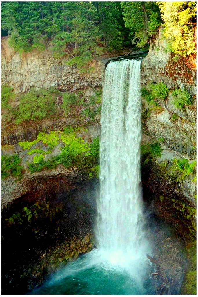
Photo Credits (2)
Difficulty
Hard
About Basalt Falls
Basalt Falls is a waterfall on the Dean River in the Chilcotin District of the Central Interior of British Columbia, located north of the community of Anahim Lake. It is approximately 12 feet (3.7 m) in height and is composed of columnar basalt of the Chilcotin Group.
The Setting
Basalt Falls sits at 1,019 metres in the mountains of British Columbia. The falls drop 4 metres.
Why This Waterfall Exists
Basalt Falls flows over Chilcotin Group, a hard volcanic rock layer deposited about 0-23 million years ago. These resistant rocks form a durable ledge that water cannot easily wear away, creating a 12-foot drop where softer material downstream has already eroded.
Trail & Hike Details
Trail Description
There is little if any reliably documented, maintained trail information for Basalt Falls. Expect an unmaintained approach that may involve route-finding over uneven, steep terrain and across creek or river banks. Trails, if they exist, may be informal boot paths or animal trails. Approach could include short but steep sections near the falls and potentially slippery rock and loose scree near basalt outcrops. Because conditions are not well-documented, plan for a remote backcountry approach.
What to Expect
The falls drop a gentle 4 metres over hard volcanic rock.
Accessibility
The trail involves steep, uneven terrain with significant elevation change and is not accessible to mobility devices.
Frequently Asked Questions
🐶 Are Dogs Allowed at Basalt Falls?
❌ Dogs are not allowed
Are There Any Fees or Permits Required?
🆖 No fees required
🏊 Is There Swimming at Basalt Falls?
❌ Swimming is not allowed
When to Visit
Late spring to early fall is generally best for access and viewing: spring/early summer for higher water flow from snowmelt; mid-to-late summer for drier, more reliable road access. Winter visits may be hazardous due to ice, snow, and impassable roads; only attempt with winter backcountry experience and proper equipment.
Seasonal Access
The best time to visit is Spring, Summer, and Fall. Winter access may be limited. Check with the managing park or local authority for current conditions.
Safety Information
Hazards may include: steep, slippery basalt and wet rock; fast and cold water with strong currents; unstable cliff edges; loose scree; remote location with limited or no cell service; variable and potentially poor road conditions (mud, washouts, seasonal closures); wildlife encounters. Carry appropriate safety gear, plan for emergencies, check road and weather conditions before travel, and avoid approaching the edge of cliffs or the crest of the falls. If uncertain about conditions, err on the side of caution and do not attempt risky routes.
Current Water Conditions
12.5 m³/s
Current discharge — how much water is flowing
About average for this time of year
Based on 60 years of record
1.20 m
Water depth at gauge
7-Day Discharge Trend
What does this mean for your visit?
Flow is about average for this time of year.
About This Gauge
This gauge is on a nearby waterway and may not reflect exact conditions at the falls.
7-Day Flow Outlook
Based on the WSC gauge DEAN RIVER BELOW TANSWANKET CREEK (18 km away).
Today
Moderate
12 m³/s
6/10Tomorrow
Moderate
12 m³/s
6/10Tue
Moderate
13 m³/s
5/10Wed
Moderate
12 m³/s
5/10Thu
Moderate
11 m³/s
6/10Fri
Moderate
10.0 m³/s
6/10Sat
Moderate
10 m³/s
5/10Best window: Today — moderate flow, cloudy (trip score 6/10).
Best time of year: this gauge typically runs highest from late April to mid July, peaking in May.
How we calculate this
This is a transparent outlook, not a precise forecast. We take the waterfall's current flow strength (how it ranks against its historical normal for today, from the nearest WSC stream gauge), carry that ranking forward along the gauge's seasonal curve, and nudge it for forecast rain. Confidence is highest for the next day or two and falls further out. Always check official conditions and your own judgment before visiting — high flows can be dangerous.
Weather Forecast
Location & Access
Getting There
The waterfall is in a remote area of northern/central British Columbia. Access will likely require driving on paved highways followed by secondary or logging roads. Roads may be rough and require high-clearance or 4x4 vehicles. Expect no formal signage; navigation by GPS coordinates (52.7984, -125.5465) and up-to-date local maps or satellite imagery is recommended. Confirm access with regional forestry or local authorities where possible.
Get Directions on Google MapsParking
No formal parking lot or facilities are known. Parking is likely informal at a roadside pullout or small clearing. Leave no trace and avoid blocking forestry roads. During spring thaw some roads may be seasonally closed or impassable.
Elevation
1,019 metres above sea level
Coordinates
52.798435° N, -125.546459° W
Visitor Tips & Gear
• Use the provided coordinates and confirm current road and access conditions before travel. • Travel with a capable vehicle; check forestry road status and spring thaw restrictions. • Tell someone your plan and expected return time; consider going with a partner. • Wear sturdy, waterproof footwear with good traction for slippery basalt and wet banks. • Bring navigation (map, compass, GPS), extra water, snacks, and layered clothing. • Practice Leave No Trace: pack out all garbage and avoid altering rock or vegetation. • Check for local landowner or First Nations access rules; permissions or seasonal restrictions may apply.
Where to Stay
Browse vacation cabins and private rentals nearby
Unique outdoor stays — tents, yurts, and treehouses
Rent a campervan or RV for your waterfall road trip
Some links are affiliate links. We may earn a commission at no extra cost to you.
Additional Information
Nearby Attractions
No documented nearby developed attractions are confirmed for this exact location. Expect remote forested landscapes, rivers, and potential logging/industrial activity in the region. Nearest services and towns are likely tens of kilometers away; plan accordingly.
Wildlife
Typical northern/central British Columbia wildlife: black bear, moose, deer, wolves, cougars, and abundant smaller mammals and birdlife. Insect activity (mosquitoes, black flies) can be significant in warm months.
Writing about Basalt Falls? Embed this waterfall on your site for free.