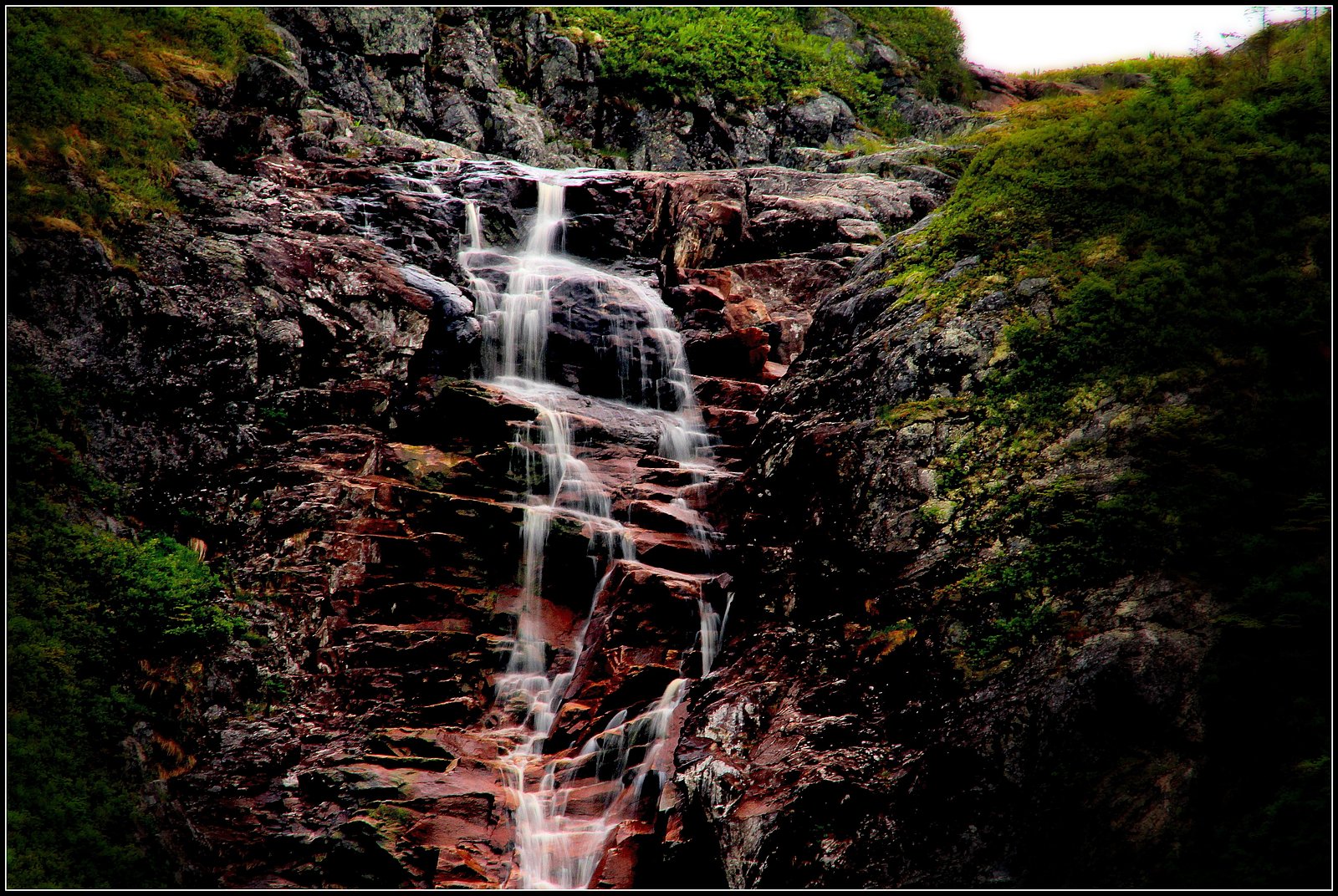
Barachois Falls
By Armen Suny · Last verified Jun 2026
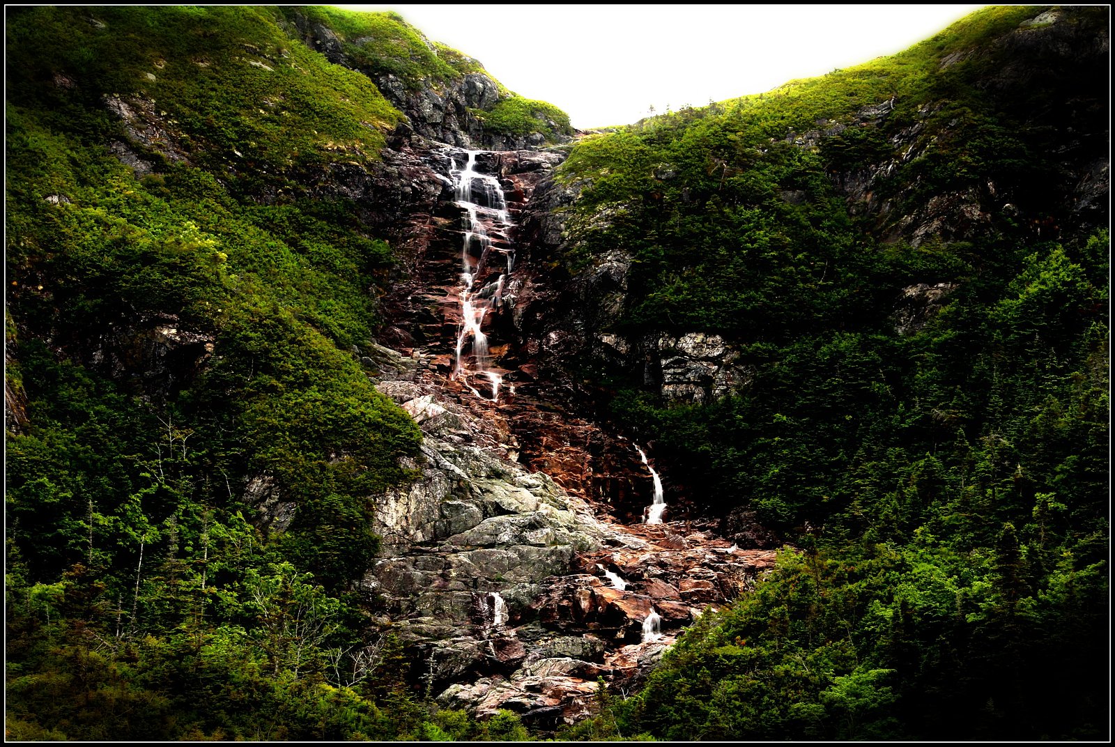

Photo Credits (2)
Difficulty
Easy
Trail Length
1.6 km
Trail Type
Out And Back
Elevation Gain
38 m
About Barachois Falls
Barachois Falls is a small, forested waterfall on the southwest coast of Newfoundland, located near Channel-Port aux Basques (approx. 18.4 miles from the town). The falls sit in a boreal forest / coastal landscape and are likely fed by a small stream or creek that flows toward a coastal barachois or inlet. Flow and appearance may be highly seasonal (higher in spring/following rain) and the site is lightly developed, offering a relatively natural, rustic waterfall experience.
Why This Waterfall Exists
Barachois Falls flows over layered sedimentary rock laid down about 444-539 million years ago. Over time, the stream has worn through these layers at different rates, creating the step that forms the waterfall.
Trail & Hike Details
The Approach
The easy 1.6-km out-and-back trail gains 38 metres of elevation on the way to the falls.
Trail Description
Approach is typically a short walk from the parking/pullout through boreal forest and shrubs. The path may be an unpaved footpath with roots, rocks, and sections that become muddy after rain. There may be short sections of scrambling to reach a good viewing spot; established boardwalks or formal infrastructure are unlikely. Trail markers and signage may be minimal.
What to Expect
A modest, natural waterfall set in coastal-boreal forest. Water volume can vary with season and rain, highest in spring and after heavy rains. Expect uneven, potentially muddy terrain, exposed tree roots, and slippery rocks near the water. Insects (blackflies, mosquitoes) can be numerous in late spring and summer. Cell coverage may be spotty.
Accessibility
The trail is not wheelchair accessible. Uneven terrain and elevation changes require steady footing.
Frequently Asked Questions
🐶 Are Dogs Allowed at Barachois Falls?
❌ Dogs are not allowed
Are There Any Fees or Permits Required?
🆖 No fees required
🏊 Is There Swimming at Barachois Falls?
❌ Swimming is not allowed
When to Visit
Late spring (high snowmelt and runoff) for strongest flows; early summer and fall for milder conditions and scenery; winter for ice formations but expect hazardous, icy conditions and possibly limited access.
Seasonal Access
The best time to visit is Spring, Summer, Fall, and Winter. Check with the managing park or local authority for current conditions.
Safety Information
Hazards include slippery rocks, unstable banks, swift or cold water, variable weather, and limited cell service. In winter, ice and deep snow can make the area dangerous; use extreme caution. Do not attempt to climb wet rocks near the fall or enter fast-flowing water. Check local conditions and let someone know your plans if traveling in remote areas.
Current Water Conditions
0.8 m³/s
Current discharge — how much water is flowing
Much lower than usual for this time of year
Based on 62 years of record
1.48 m
Water depth at gauge
7-Day Discharge Trend
What does this mean for your visit?
Flow is well below normal for this time of year, so the waterfall may be a trickle.
About This Gauge
This gauge is on a nearby waterway and may not reflect exact conditions at the falls.
7-Day Flow Outlook
Based on the WSC gauge ISLE AUX MORTS RIVER BELOW HIGHWAY BRIDGE (18 km away).
Today
Barely Flowing
0.8 m³/s
3/10Tomorrow
Low
0.9 m³/s
4/10Tue
Barely Flowing
0.8 m³/s
4/10Wed
Barely Flowing
0.9 m³/s
3/10Thu
Low
0.9 m³/s
3/10Fri
Low
1.0 m³/s
4/10Sat
Low
0.9 m³/s
4/10Best window: Tomorrow — low flow, light drizzle (trip score 4/10).
Best time of year: this gauge typically runs highest from early April to early June, peaking in May.
How we calculate this
This is a transparent outlook, not a precise forecast. We take the waterfall's current flow strength (how it ranks against its historical normal for today, from the nearest WSC stream gauge), carry that ranking forward along the gauge's seasonal curve, and nudge it for forecast rain. Confidence is highest for the next day or two and falls further out. Always check official conditions and your own judgment before visiting — high flows can be dangerous.
Know when to go.
Get a free email alert when waterfalls near Channel-Port aux Basques hit peak flow. We only send when conditions are worth the trip — no weekly newsletters, no spam.
Weather Forecast
Location & Access
Getting There
From Channel-Port aux Basques (approx. 18.4 miles), travel on local roads off the main highway toward the inland coastal area. Exact turnoffs and signage may be limited; use GPS coordinates (47.6117, -58.7671) or a detailed map. Expect a mix of paved and secondary roads; some last-mile access may be on gravel.
Get Directions on Google MapsParking
Small parking area or roadside pullout near the trailhead is likely; spaces may be limited and surfaces may be gravel or dirt. Park well off the traveled portion of any road.
Elevation
37 metres above sea level
Coordinates
47.611664° N, -58.767114° W
Visitor Tips & Gear
Wear sturdy, water-resistant footwear with good traction. Bring rain gear and insect repellent in warm months. Stay back from edges and unstable banks, rocks near the falls can be very slippery. Leave no trace: pack out all trash. Check local weather and road conditions before travel; isolate areas may have limited services.
As an Amazon Associate, we earn from qualifying purchases.
This easy 1.6 km hike is straightforward — comfortable trail shoes and plenty of water should do. Icy conditions are common in winter — traction cleats are a smart addition.

Columbia Watertight II Rain Jacket
Packs into its own pocket, seam-sealed, and keeps you dry from spray and surprise rain.

Polarized Sunglasses (Knockaround)
Cuts glare off the water so you actually see the falls — and your photos turn out better too.

Earth Pak Waterproof Dry Bag
Keeps your phone and gear dry when waterfall mist soaks everything else.

Waterproof Phone Pouch (AiRunTech)
Cheap insurance — take photos right next to the falls without killing your phone.

Kahtoola MICROspikes
Cult-favorite traction cleats that grip ice and wet rock — essential for winter waterfall hikes.

JOBY GorillaPod Starter Kit
Wraps around railings and rocks for long-exposure waterfall shots — no flat surface needed.
Where to Stay
Browse vacation cabins and private rentals nearby
Unique outdoor stays — tents, yurts, and treehouses
Rent a campervan or RV for your waterfall road trip
Some links are affiliate links. We may earn a commission at no extra cost to you.
Additional Information
Nearby Attractions
The falls are located in southwestern Newfoundland near Channel-Port aux Basques (approx. 18.4 miles). The surrounding coastline offers scenic viewpoints and small coastal communities to explore; allow extra time to visit local coastal scenery.
Wildlife
Typical regional wildlife may include seabirds and waterfowl near coastal areas, small mammals, and larger mammals such as moose. Insects (blackflies, mosquitoes) can be common in warmer months.
Cities near Barachois Falls
Writing about Barachois Falls? Embed this waterfall on your site for free.